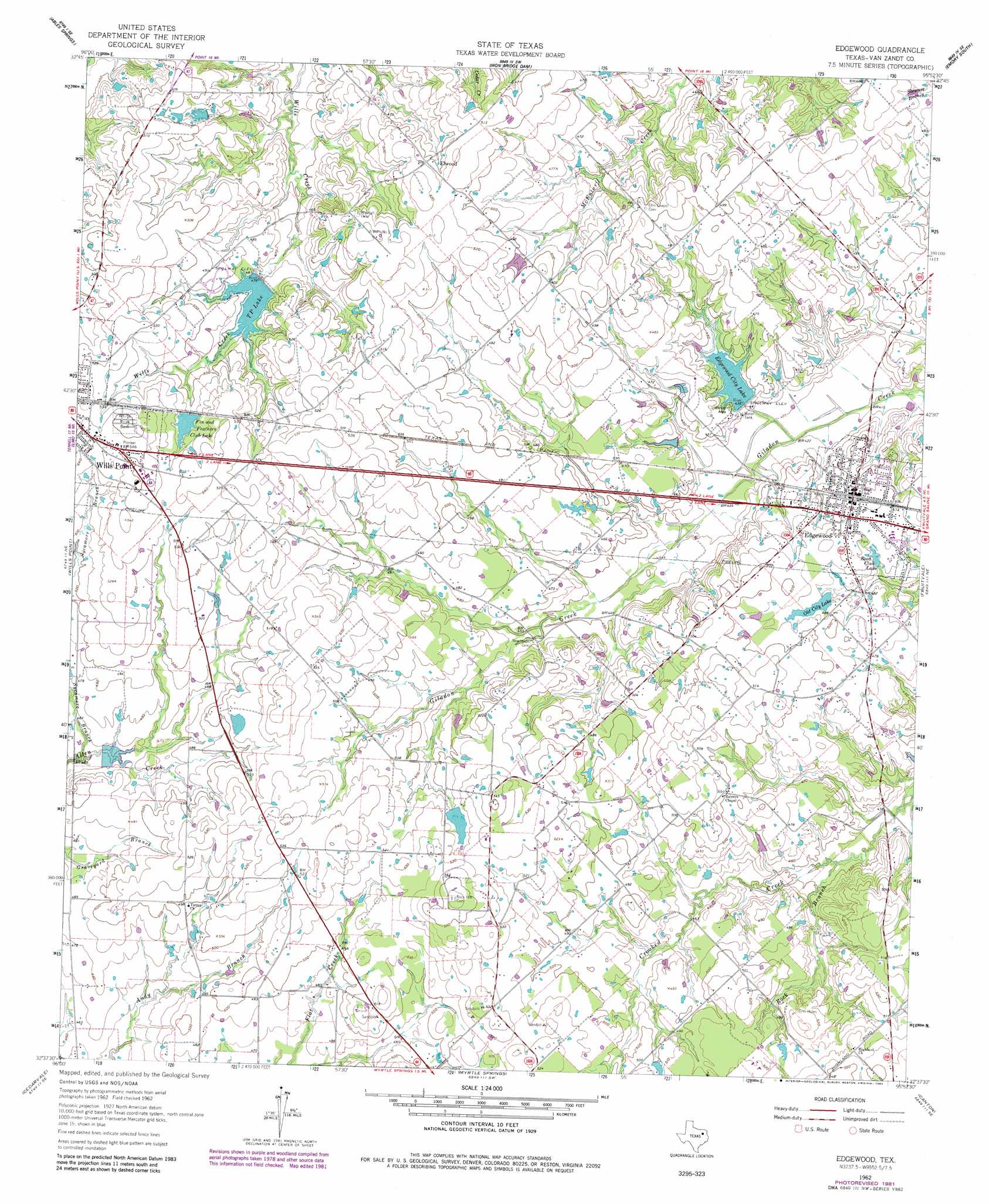
Edgewood Topo Map Texas
To zoom in, hover over the map of Edgewood
USGS Topo Quad 32095f8 - 1:24,000 scale
| Topo Map Name: | Edgewood |
| USGS Topo Quad ID: | 32095f8 |
| Print Size: | ca. 21 1/4" wide x 27" high |
| Southeast Coordinates: | 32.625° N latitude / 95.875° W longitude |
| Map Center Coordinates: | 32.6875° N latitude / 95.9375° W longitude |
| U.S. State: | TX |
| Filename: | o32095f8.jpg |
| Download Map JPG Image: | Edgewood topo map 1:24,000 scale |
| Map Type: | Topographic |
| Topo Series: | 7.5´ |
| Map Scale: | 1:24,000 |
| Source of Map Images: | United States Geological Survey (USGS) |
| Alternate Map Versions: |
Edgewood TX 1962, updated 1966 Download PDF Buy paper map Edgewood TX 1962, updated 1982 Download PDF Buy paper map Edgewood TX 2010 Download PDF Buy paper map Edgewood TX 2012 Download PDF Buy paper map Edgewood TX 2016 Download PDF Buy paper map |
1:24,000 Topo Quads surrounding Edgewood
Quinlan |
West Tawakoni |
Lone Oak South |
Emory North |
Arbala |
Poetry |
Ables Springs |
Iron Bridge Dam |
Emory South |
Alba |
Elmo |
Wills Point |
Edgewood |
Fruitvale |
Grand Saline |
Ola |
Cedarvale |
Myrtle Springs |
Canton |
Van |
Kemp |
Prairieville |
Phalba |
Martins Mill |
Ben Wheeler |
> Back to 32095e1 at 1:100,000 scale
> Back to 32094a1 at 1:250,000 scale
> Back to U.S. Topo Maps home
Edgewood topo map: Gazetteer
Edgewood: Airports
Wills Point Municipal Airport elevation 155m 508′Edgewood: Dams
Callaway Lake Dam elevation 154m 505′Edgewood City Lake Dam elevation 130m 426′
Fin and Feather Club Lake Dam elevation 153m 501′
Hamilton Lake Dam elevation 155m 508′
Old City Lake Dam elevation 148m 485′
Soil Conservation Service Site 104 Dam elevation 140m 459′
Willow Lake Dam elevation 143m 469′
Edgewood: Lakes
Reed Club Lake elevation 141m 462′Edgewood: Populated Places
Edgewood elevation 140m 459′Elwood elevation 154m 505′
Edgewood: Reservoirs
Callaway Lake elevation 154m 505′Edgewood City Lake elevation 134m 439′
Fin and Feather Club Lake elevation 153m 501′
Fin and Feathers Club Lake elevation 155m 508′
Hamilton Lake elevation 155m 508′
Old City Lake elevation 147m 482′
Soil Conservation Service Site 104 Reservoir elevation 140m 459′
T P Lake elevation 146m 479′
Willow Lake elevation 143m 469′
Edgewood: Streams
Rock Branch elevation 134m 439′Sycamore Branch elevation 137m 449′
Edgewood digital topo map on disk
Buy this Edgewood topo map showing relief, roads, GPS coordinates and other geographical features, as a high-resolution digital map file on DVD: