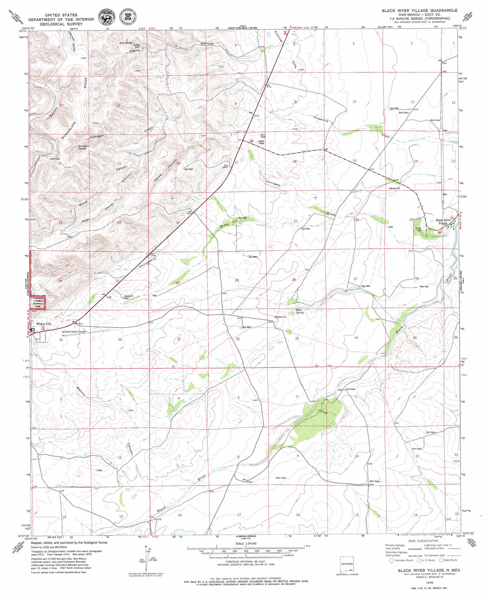
Black River Village Topo Map New Mexico
To zoom in, hover over the map of Black River Village
USGS Topo Quad 32104b3 - 1:24,000 scale
| Topo Map Name: | Black River Village |
| USGS Topo Quad ID: | 32104b3 |
| Print Size: | ca. 21 1/4" wide x 27" high |
| Southeast Coordinates: | 32.125° N latitude / 104.25° W longitude |
| Map Center Coordinates: | 32.1875° N latitude / 104.3125° W longitude |
| U.S. State: | NM |
| Filename: | o32104b3.jpg |
| Download Map JPG Image: | Black River Village topo map 1:24,000 scale |
| Map Type: | Topographic |
| Topo Series: | 7.5´ |
| Map Scale: | 1:24,000 |
| Source of Map Images: | United States Geological Survey (USGS) |
| Alternate Map Versions: |
Black River Village NM 1979, updated 1979 Download PDF Buy paper map Black River Village NM 2010 Download PDF Buy paper map Black River Village NM 2013 Download PDF Buy paper map Black River Village NM 2017 Download PDF Buy paper map |
1:24,000 Topo Quads surrounding Black River Village
Martha Creek |
Azotea Peak |
Carlsbad West |
Carlsbad East |
Indian Flats |
Bandanna Point |
Carnero Peak |
Kitchen Cove |
Otis |
Loving |
Serpentine Bends |
Carlsbad Caverns |
Black River Village |
Bond Draw |
Malaga |
Grapevine Draw |
Rattlesnake Spring |
Jumping Spring |
Cottonwood Hills |
Red Bluff |
South Rector Canyon |
Alligator Draw |
Outlaw Spring |
Owl Hills |
Screw Bean Draw Ne |
> Back to 32104a1 at 1:100,000 scale
> Back to 32104a1 at 1:250,000 scale
> Back to U.S. Topo Maps home
Black River Village topo map: Gazetteer
Black River Village: Airports
Carlsbad Cavern Airpark elevation 1094m 3589′Black River Village: Mines
Anna B Byrd elevation 1089m 3572′Black River Village: Populated Places
Black River Village elevation 983m 3225′Black River Village: Springs
Blue Spring elevation 1012m 3320′Box Spring elevation 1135m 3723′
Castle Spring elevation 995m 3264′
Jurnigan Spring elevation 1178m 3864′
Black River Village: Valleys
Chinaberry Draw elevation 1007m 3303′Fence Canyon elevation 1100m 3608′
Goat Corral Canyon elevation 1115m 3658′
Jurnigan Draw elevation 1007m 3303′
Walnut Canyon elevation 1024m 3359′
Wood Canyon elevation 1091m 3579′
Black River Village: Wells
06613 Water Well elevation 1040m 3412′06614 Water Well elevation 1056m 3464′
06615 Water Well elevation 1044m 3425′
06618 Water Well elevation 1019m 3343′
07039 Water Well elevation 994m 3261′
10301 Water Well elevation 995m 3264′
10471 Water Well elevation 993m 3257′
20054 Water Well elevation 1072m 3517′
20056 Water Well elevation 1122m 3681′
20058 Water Well elevation 998m 3274′
20059 Water Well elevation 1043m 3421′
20070 Water Well elevation 1047m 3435′
Elbow Well elevation 1118m 3667′
Woodruff Well elevation 1072m 3517′
Black River Village digital topo map on disk
Buy this Black River Village topo map showing relief, roads, GPS coordinates and other geographical features, as a high-resolution digital map file on DVD: