Riddleville Topo Map Georgia
To zoom in, hover over the map of Riddleville
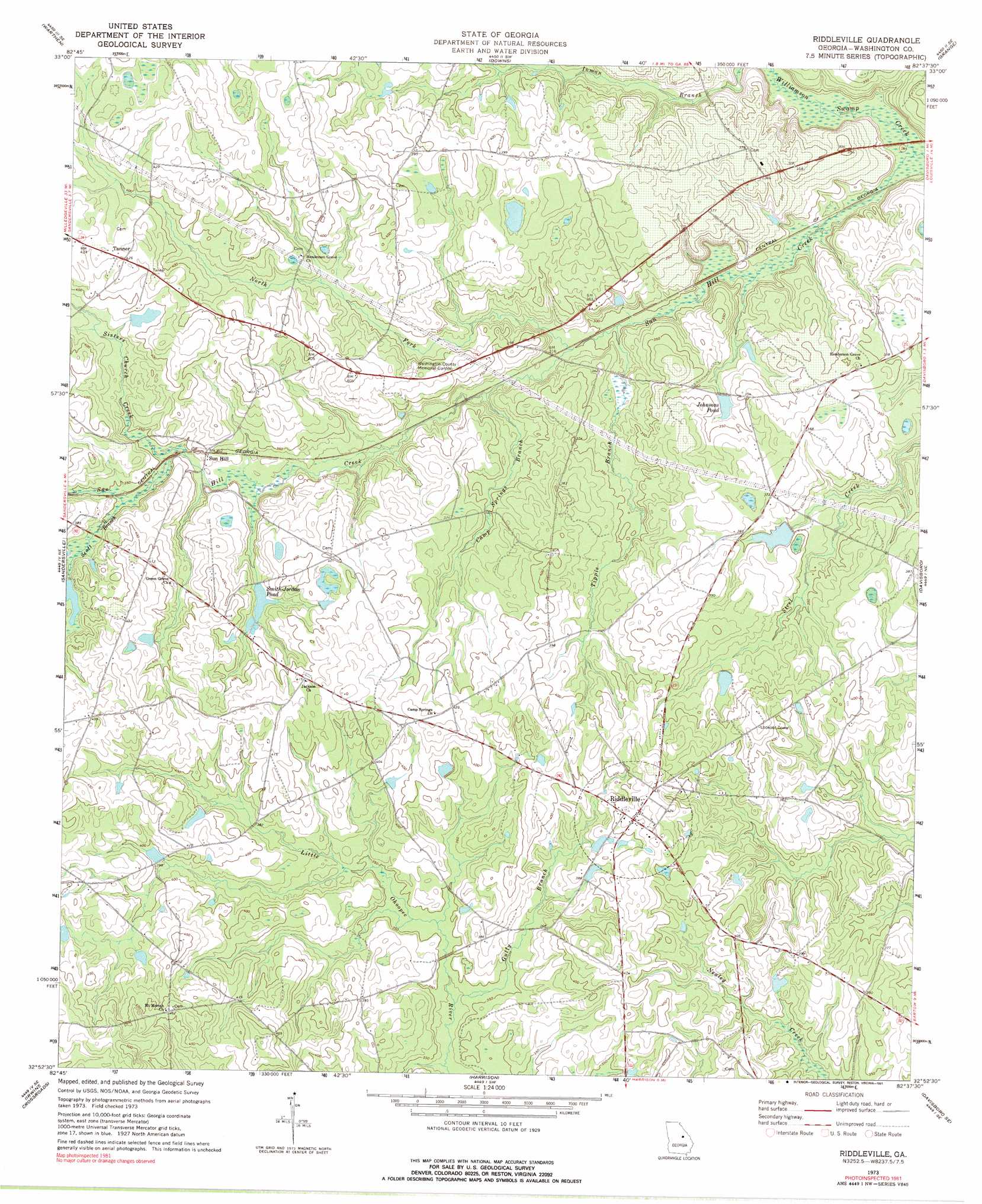
USGS Topo Quad 32082h6 - 1:24,000 scale
| Topo Map Name: | Riddleville |
| USGS Topo Quad ID: | 32082h6 |
| Print Size: | ca. 21 1/4" wide x 27" high |
| Southeast Coordinates: | 32.875° N latitude / 82.625° W longitude |
| Map Center Coordinates: | 32.9375° N latitude / 82.6875° W longitude |
| U.S. State: | GA |
| Filename: | o32082h6.jpg |
| Download Map JPG Image: | Riddleville topo map 1:24,000 scale |
| Map Type: | Topographic |
| Topo Series: | 7.5´ |
| Map Scale: | 1:24,000 |
| Source of Map Images: | United States Geological Survey (USGS) |
| Alternate Map Versions: |
Riddleville GA 1973, updated 1976 Download PDF Buy paper map Riddleville GA 1973, updated 1991 Download PDF Buy paper map Riddleville GA 2011 Download PDF Buy paper map Riddleville GA 2014 Download PDF Buy paper map |
1:24,000 Topo Quads surrounding Riddleville
Warthen Nw |
Warthen Ne |
Mitchell |
Gibson |
Wrens |
Deepstep |
Warthen |
Downs |
Grange |
Louisville |
Tabernacle |
Sandersville |
Riddleville |
Davisboro |
Louisville South |
Oconee |
Irwins Crossroads |
Harrison |
Davisboro Se |
Wadley |
Cow Hell Swamp |
Lovett |
Wrightsville |
Kite |
Dellwood |
> Back to 32082e1 at 1:100,000 scale
> Back to 32082a1 at 1:250,000 scale
> Back to U.S. Topo Maps home
Riddleville topo map: Gazetteer
Riddleville: Dams
Bretts Lake Dam elevation 121m 396′Ethridge Lake Dam elevation 114m 374′
Morris Lake Dam elevation 114m 374′
Pat Pate Dam elevation 104m 341′
Sheppard Lake Dam elevation 104m 341′
Smith-Jordan Pond Dam elevation 110m 360′
Riddleville: Populated Places
Heidrich elevation 91m 298′Riddleville elevation 125m 410′
Rose elevation 115m 377′
Sun Hill elevation 107m 351′
Tanner elevation 128m 419′
Riddleville: Reservoirs
Bretts Lake elevation 121m 396′Ethridge Lake elevation 114m 374′
Johnsons Pond elevation 101m 331′
McCoys Pond elevation 97m 318′
Morris Lake elevation 114m 374′
Sheppard Lake elevation 104m 341′
Smith-Jordan Pond elevation 110m 360′
Riddleville: Streams
Camp Springs Branch elevation 94m 308′Gully Branch elevation 103m 337′
Joiners Branch elevation 116m 380′
North Fork Sun Hill Creek elevation 92m 301′
Rogers Branch elevation 109m 357′
Scott Branch elevation 105m 344′
Sisters Church Creek elevation 102m 334′
Sun Hill Creek elevation 83m 272′
Tippie Branch elevation 91m 298′
Riddleville digital topo map on disk
Buy this Riddleville topo map showing relief, roads, GPS coordinates and other geographical features, as a high-resolution digital map file on DVD:
South Carolina, Western North Carolina & Northeastern Georgia
Buy digital topo maps: South Carolina, Western North Carolina & Northeastern Georgia