Felton Topo Map Georgia
To zoom in, hover over the map of Felton
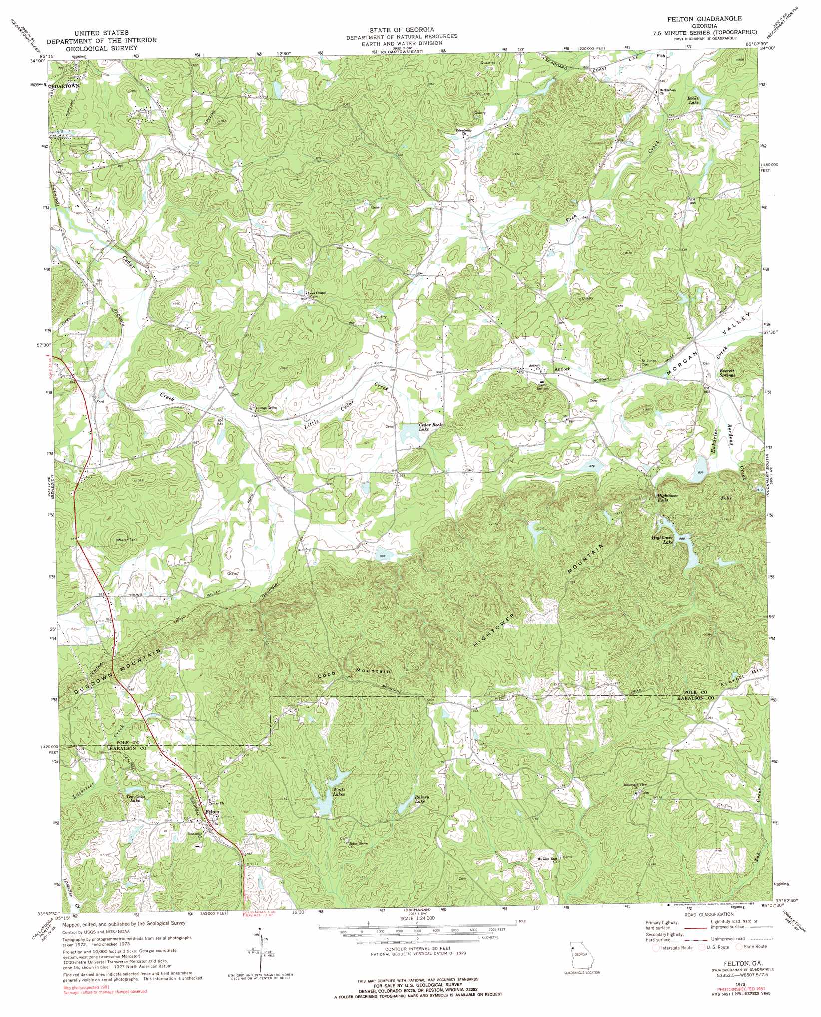
USGS Topo Quad 33085h2 - 1:24,000 scale
| Topo Map Name: | Felton |
| USGS Topo Quad ID: | 33085h2 |
| Print Size: | ca. 21 1/4" wide x 27" high |
| Southeast Coordinates: | 33.875° N latitude / 85.125° W longitude |
| Map Center Coordinates: | 33.9375° N latitude / 85.1875° W longitude |
| U.S. State: | GA |
| Filename: | o33085h2.jpg |
| Download Map JPG Image: | Felton topo map 1:24,000 scale |
| Map Type: | Topographic |
| Topo Series: | 7.5´ |
| Map Scale: | 1:24,000 |
| Source of Map Images: | United States Geological Survey (USGS) |
| Alternate Map Versions: |
Felton GA 1973, updated 1975 Download PDF Buy paper map Felton GA 1973, updated 1991 Download PDF Buy paper map Felton GA 2011 Download PDF Buy paper map Felton GA 2014 Download PDF Buy paper map |
1:24,000 Topo Quads surrounding Felton
Melson |
Livingston |
Rome South |
Wax |
Kingston |
Indian Mountain |
Cedartown West |
Cedartown East |
Rockmart North |
Tayorsville |
Borden Springs |
Benedict |
Felton |
Rockmart South |
Yorkville |
Oak Level |
Tallapoosa North |
Buchanan |
Draketown |
New Georgia |
Fruithurst |
Tallapoosa South |
Bremen |
Temple |
Villa Rica |
> Back to 33085e1 at 1:100,000 scale
> Back to 33084a1 at 1:250,000 scale
> Back to U.S. Topo Maps home
Felton topo map: Gazetteer
Felton: Dams
Big Cedar Creek Structure Number 50 Dam elevation 280m 918′Cedar Rock Lake Dam elevation 274m 898′
Euharlee Creek Structure Number 51 Dam elevation 283m 928′
Euharlee Creek Structure Number 76 Dam elevation 263m 862′
Euharlee Creek Structure Number Four Dam elevation 267m 875′
Hightower Lake Dam Number One elevation 301m 987′
Hobson Lake Dam elevation 339m 1112′
North Watts Lake Dam elevation 332m 1089′
Felton: Falls
Hightower Falls elevation 290m 951′Felton: Populated Places
Antioch elevation 262m 859′Felton elevation 365m 1197′
Fish elevation 248m 813′
Winkles (historical) elevation 317m 1040′
Youngs elevation 256m 839′
Felton: Post Offices
Felton Post Office elevation 360m 1181′Felton: Reservoirs
Becks Lake elevation 252m 826′Cedar Rock Lake elevation 274m 898′
Davis Lake elevation 267m 875′
Everett Lake elevation 283m 928′
Hightower Lake elevation 301m 987′
Hobson Lake elevation 339m 1112′
Lindsey Lake elevation 280m 918′
Lower Hightower Falls Lake elevation 263m 862′
North Watts Lake elevation 332m 1089′
Rainey Lake elevation 337m 1105′
Ten Oaks Lake elevation 329m 1079′
Watts Lakes elevation 328m 1076′
Felton: Springs
Everett Springs elevation 253m 830′Philpott Spring elevation 238m 780′
Youngs Spring elevation 258m 846′
Felton: Streams
Bordens Creek elevation 256m 839′Little Cedar Creek elevation 256m 839′
Felton: Summits
Cobb Mountain elevation 382m 1253′Hightower Mountain elevation 395m 1295′
Felton digital topo map on disk
Buy this Felton topo map showing relief, roads, GPS coordinates and other geographical features, as a high-resolution digital map file on DVD: