Livingston Topo Map Georgia
To zoom in, hover over the map of Livingston
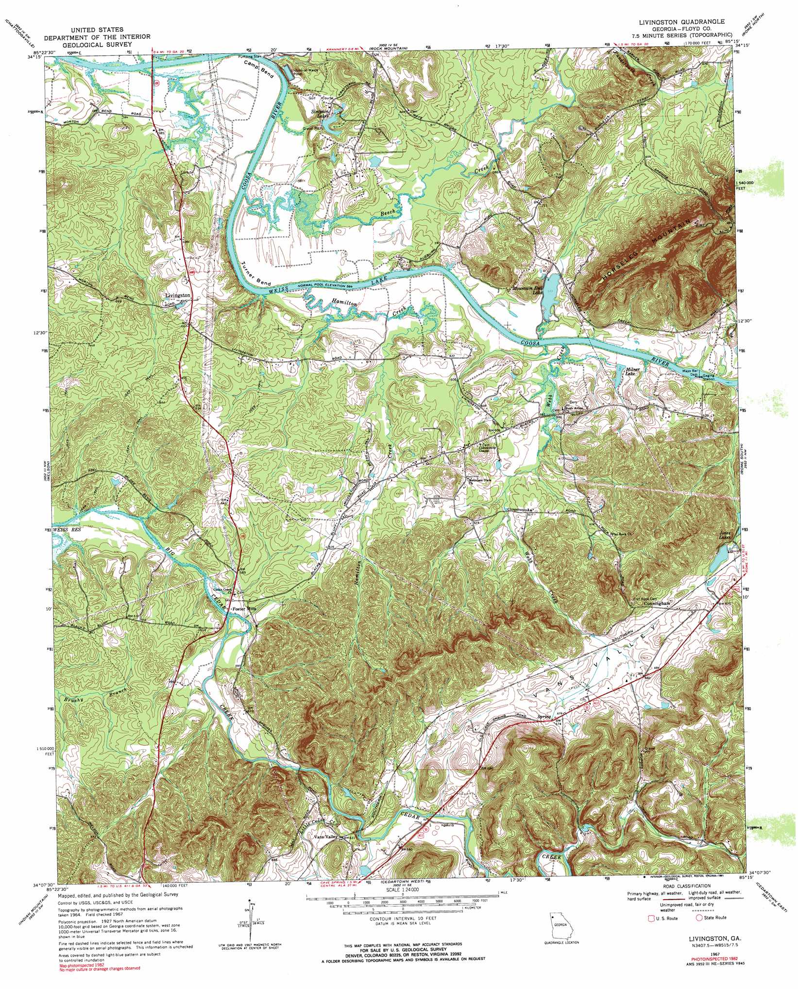
USGS Topo Quad 34085b3 - 1:24,000 scale
| Topo Map Name: | Livingston |
| USGS Topo Quad ID: | 34085b3 |
| Print Size: | ca. 21 1/4" wide x 27" high |
| Southeast Coordinates: | 34.125° N latitude / 85.25° W longitude |
| Map Center Coordinates: | 34.1875° N latitude / 85.3125° W longitude |
| U.S. State: | GA |
| Filename: | o34085b3.jpg |
| Download Map JPG Image: | Livingston topo map 1:24,000 scale |
| Map Type: | Topographic |
| Topo Series: | 7.5´ |
| Map Scale: | 1:24,000 |
| Source of Map Images: | United States Geological Survey (USGS) |
| Alternate Map Versions: |
Livingston GA 1967, updated 1970 Download PDF Buy paper map Livingston GA 1967, updated 1991 Download PDF Buy paper map Livingston GA 2011 Download PDF Buy paper map Livingston GA 2014 Download PDF Buy paper map |
1:24,000 Topo Quads surrounding Livingston
Jamestown |
Lyerly |
Summerville |
Armuchee |
Plainville |
Gaylesville |
Chattoogaville |
Rock Mountain |
Rome North |
Shannon |
Cedar Bluff |
Melson |
Livingston |
Rome South |
Wax |
Ellisville |
Indian Mountain |
Cedartown West |
Cedartown East |
Rockmart North |
Piedmont |
Borden Springs |
Benedict |
Felton |
Rockmart South |
> Back to 34085a1 at 1:100,000 scale
> Back to 34084a1 at 1:250,000 scale
> Back to U.S. Topo Maps home
Livingston topo map: Gazetteer
Livingston: Bends
Camp Bend elevation 177m 580′Turner Bend elevation 177m 580′
Livingston: Crossings
Neals Ferry (historical) elevation 174m 570′Livingston: Dams
Heavy Liquor Pond Dam elevation 192m 629′Jones Lake Dam elevation 215m 705′
Kraft Industrial Waste Pond Dam elevation 176m 577′
Mayo Bar Dam elevation 177m 580′
Mountain End Lake Dam elevation 176m 577′
Simpson Lake Dam elevation 192m 629′
Livingston: Parks
Alto Park Recreation Center elevation 212m 695′Floyd County Recreation Area elevation 177m 580′
Livingston: Populated Places
Cunningham elevation 210m 688′Foster Mills elevation 178m 583′
Friendship elevation 195m 639′
Landers (historical) elevation 210m 688′
Livingston elevation 205m 672′
Vans Valley elevation 193m 633′
Yancey (historical) elevation 216m 708′
Livingston: Reservoirs
Heavy Liquor Pond elevation 192m 629′Jones Lake elevation 215m 705′
Jones Lakes elevation 199m 652′
Kraft Industrial Waste Pond elevation 176m 577′
Milner Lake elevation 177m 580′
Mountain End Lake elevation 176m 577′
Simpson Lake elevation 192m 629′
Simpson Lakes elevation 186m 610′
Livingston: Springs
Cress Spring elevation 206m 675′Livingston: Streams
Beech Creek elevation 174m 570′Dry Creek elevation 185m 606′
Hamilton Creek elevation 175m 574′
Little Cedar Creek elevation 183m 600′
Mill Race elevation 174m 570′
Webb Creek elevation 174m 570′
Livingston: Valleys
Vans Valley elevation 188m 616′Livingston digital topo map on disk
Buy this Livingston topo map showing relief, roads, GPS coordinates and other geographical features, as a high-resolution digital map file on DVD: