Pat Mayse Lake West Topo Map Texas
To zoom in, hover over the map of Pat Mayse Lake West
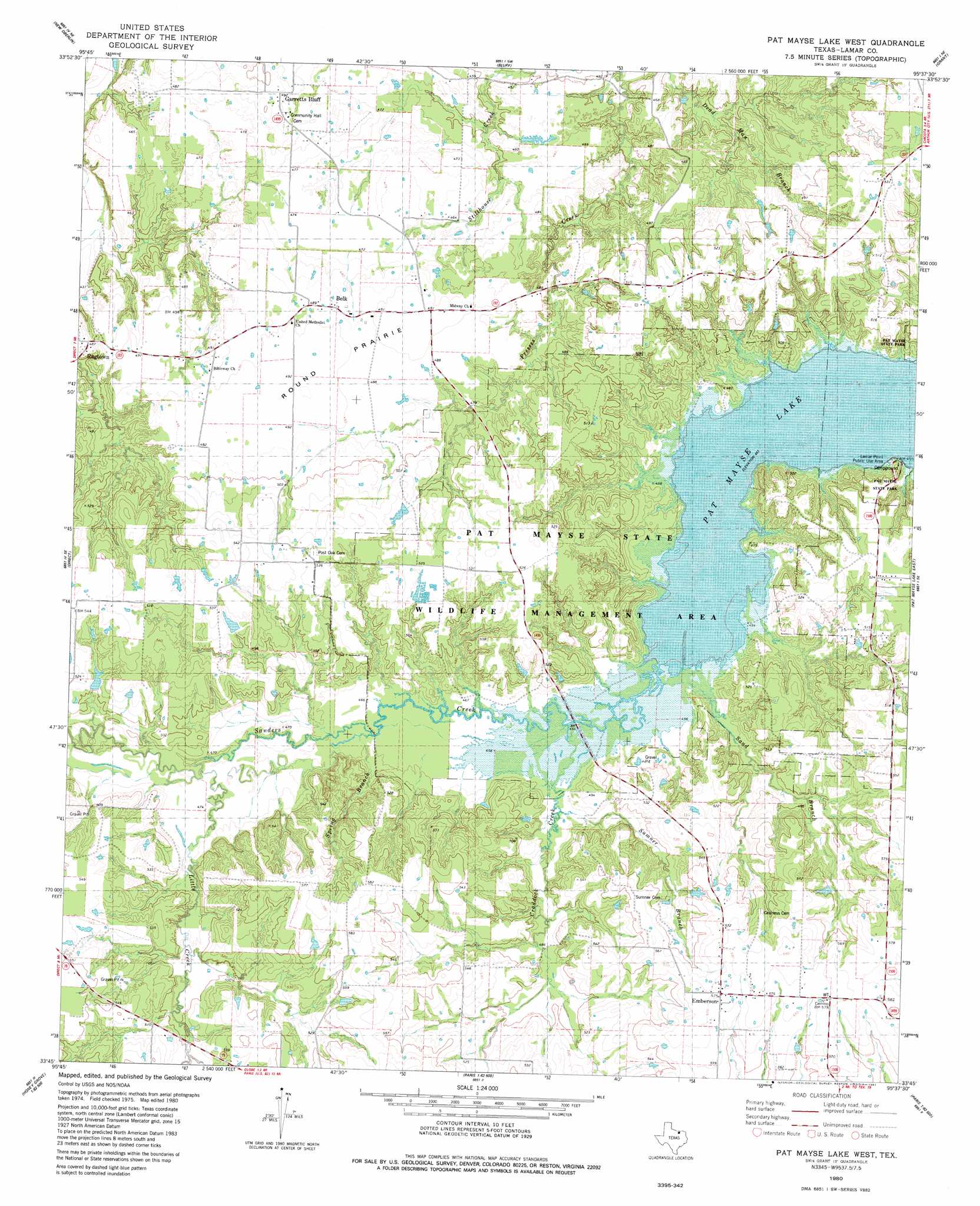
USGS Topo Quad 33095g6 - 1:24,000 scale
| Topo Map Name: | Pat Mayse Lake West |
| USGS Topo Quad ID: | 33095g6 |
| Print Size: | ca. 21 1/4" wide x 27" high |
| Southeast Coordinates: | 33.75° N latitude / 95.625° W longitude |
| Map Center Coordinates: | 33.8125° N latitude / 95.6875° W longitude |
| U.S. State: | TX |
| Filename: | o33095g6.jpg |
| Download Map JPG Image: | Pat Mayse Lake West topo map 1:24,000 scale |
| Map Type: | Topographic |
| Topo Series: | 7.5´ |
| Map Scale: | 1:24,000 |
| Source of Map Images: | United States Geological Survey (USGS) |
| Alternate Map Versions: |
Pat Mayse Lake West TX 1980, updated 1981 Download PDF Buy paper map Pat Mayse Lake West TX 2011 Download PDF Buy paper map Pat Mayse Lake West TX 2013 Download PDF Buy paper map Pat Mayse Lake West TX 2016 Download PDF Buy paper map |
1:24,000 Topo Quads surrounding Pat Mayse Lake West
Boswell Sw |
Boswell |
Soper |
Hugo |
Hugo Dam |
Lake West |
New Oberlin |
Bluff |
Grant |
Shoals |
Monkstown |
Direct |
Pat Mayse Lake West |
Pat Mayse Lake East |
Slate Shoals |
Selfs |
Tigertown |
Toco |
Paris |
Blossom |
Honey Grove |
Petty |
Roxton |
Biardstown |
Pattonville |
> Back to 33095e1 at 1:100,000 scale
> Back to 33094a1 at 1:250,000 scale
> Back to U.S. Topo Maps home
Pat Mayse Lake West topo map: Gazetteer
Pat Mayse Lake West: Capes
Lamar Point elevation 139m 456′Pat Mayse Lake West: Dams
Campbell Lake Dam elevation 153m 501′Willow Lake Dam elevation 144m 472′
Pat Mayse Lake West: Flats
Round Prairie elevation 150m 492′Pat Mayse Lake West: Parks
Pat Mayse State Park 1 elevation 151m 495′Pat Mayse State Park 2 elevation 157m 515′
Pat Mayse Lake West: Populated Places
Belk elevation 149m 488′Emberson elevation 175m 574′
Garretts Bluff elevation 151m 495′
Ragtown elevation 145m 475′
Pat Mayse Lake West: Reservoirs
Campbell Lake elevation 153m 501′Willow Lake elevation 144m 472′
Pat Mayse Lake West: Streams
Craddock Creek elevation 140m 459′Little Creek elevation 143m 469′
Sand Branch elevation 138m 452′
Spring Branch elevation 140m 459′
Summer Branch elevation 141m 462′
Pat Mayse Lake West digital topo map on disk
Buy this Pat Mayse Lake West topo map showing relief, roads, GPS coordinates and other geographical features, as a high-resolution digital map file on DVD: