Bear Mountain Topo Map New Mexico
To zoom in, hover over the map of Bear Mountain
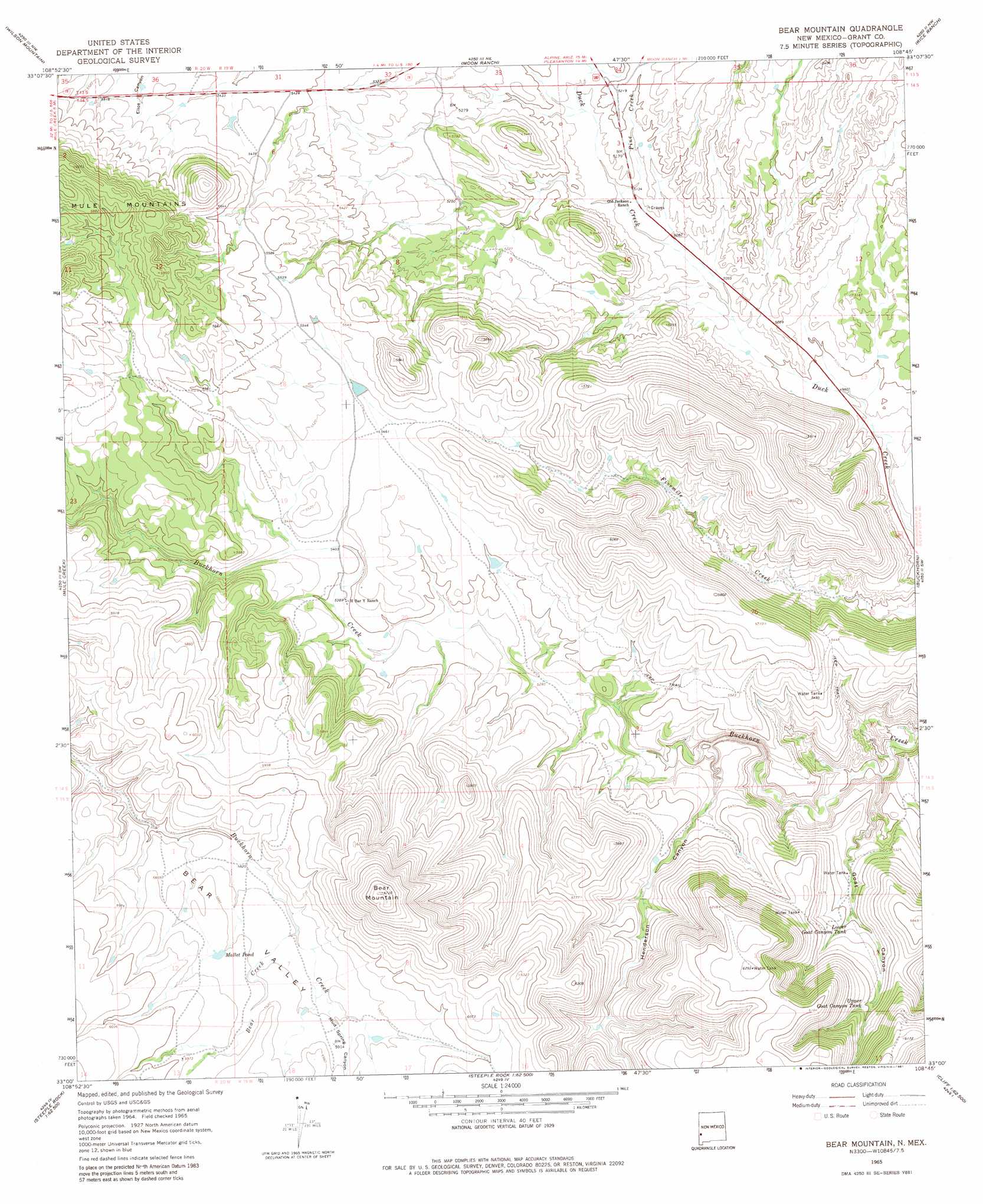
USGS Topo Quad 33108a7 - 1:24,000 scale
| Topo Map Name: | Bear Mountain |
| USGS Topo Quad ID: | 33108a7 |
| Print Size: | ca. 21 1/4" wide x 27" high |
| Southeast Coordinates: | 33° N latitude / 108.75° W longitude |
| Map Center Coordinates: | 33.0625° N latitude / 108.8125° W longitude |
| U.S. State: | NM |
| Filename: | o33108a7.jpg |
| Download Map JPG Image: | Bear Mountain topo map 1:24,000 scale |
| Map Type: | Topographic |
| Topo Series: | 7.5´ |
| Map Scale: | 1:24,000 |
| Source of Map Images: | United States Geological Survey (USGS) |
| Alternate Map Versions: |
Bear Mountain NM 1965, updated 1969 Download PDF Buy paper map Bear Mountain NM 1965, updated 1981 Download PDF Buy paper map Bear Mountain NM 2010 Download PDF Buy paper map Bear Mountain NM 2013 Download PDF Buy paper map Bear Mountain NM 2017 Download PDF Buy paper map |
1:24,000 Topo Quads surrounding Bear Mountain
Maple Peak |
Glenwood |
Holt Mountain |
Grouse Mountain |
Mogollon Baldy Peak |
Harden Cienega |
Wilson Mountain |
Moon Ranch |
Rice Ranch |
Shelley Peak |
Big Lue Mountains |
Mule Creek |
Bear Mountain |
Buckhorn |
Canteen Canyon |
Tillie Hall Peak |
Crookson Peak |
Applegate Mountain |
Antelope Ridge |
Cliff |
Goat Camp Spring |
Steeple Rock |
Walker Canyon |
Brushy Mountain |
Mangas Springs |
> Back to 33108a1 at 1:100,000 scale
> Back to 33108a1 at 1:250,000 scale
> Back to U.S. Topo Maps home
Bear Mountain topo map: Gazetteer
Bear Mountain: Reservoirs
Lower Goat Canyon Tank elevation 1646m 5400′Mallet Pond elevation 1793m 5882′
Upper Goat Canyon Tank elevation 1709m 5606′
Bear Mountain: Streams
Bear Creek elevation 1782m 5846′Pine Creek elevation 1556m 5104′
Bear Mountain: Summits
Bear Mountain elevation 2051m 6729′Bear Mountain: Valleys
Bear Valley elevation 1757m 5764′Goat Canyon elevation 1514m 4967′
Henderson Canyon elevation 1565m 5134′
Mud Spring Canyon elevation 1791m 5875′
Bear Mountain digital topo map on disk
Buy this Bear Mountain topo map showing relief, roads, GPS coordinates and other geographical features, as a high-resolution digital map file on DVD: