Singletary Lake Topo Map North Carolina
To zoom in, hover over the map of Singletary Lake
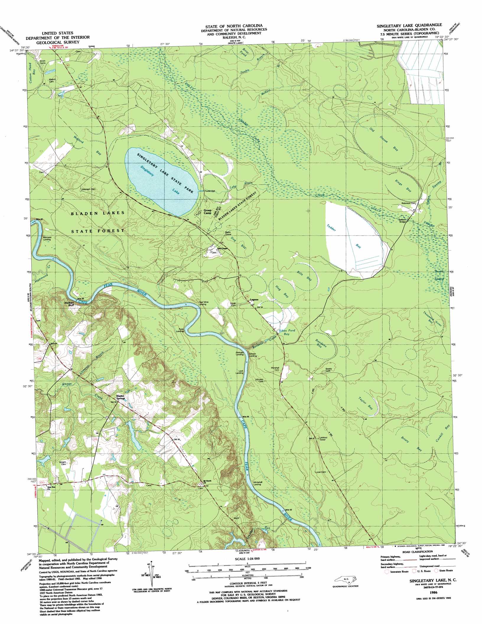
USGS Topo Quad 34078e4 - 1:24,000 scale
| Topo Map Name: | Singletary Lake |
| USGS Topo Quad ID: | 34078e4 |
| Print Size: | ca. 21 1/4" wide x 27" high |
| Southeast Coordinates: | 34.5° N latitude / 78.375° W longitude |
| Map Center Coordinates: | 34.5625° N latitude / 78.4375° W longitude |
| U.S. State: | NC |
| Filename: | o34078e4.jpg |
| Download Map JPG Image: | Singletary Lake topo map 1:24,000 scale |
| Map Type: | Topographic |
| Topo Series: | 7.5´ |
| Map Scale: | 1:24,000 |
| Source of Map Images: | United States Geological Survey (USGS) |
| Alternate Map Versions: |
Singletary Lake NC 1986, updated 1986 Download PDF Buy paper map Singletary Lake NC 2002, updated 2002 Download PDF Buy paper map Singletary Lake NC 2010 Download PDF Buy paper map Singletary Lake NC 2013 Download PDF Buy paper map Singletary Lake NC 2016 Download PDF Buy paper map |
1:24,000 Topo Quads surrounding Singletary Lake
Jerome |
Ammon |
Garland |
Ingold |
Delway |
Dublin |
Elizabethtown North |
White Lake |
Tomahawk |
Harrells |
Abbottsburg |
Elizabethtown South |
Singletary Lake |
Rowan |
Atkinson |
Clarkton |
Emerson |
Council |
Kelly |
Point Caswell |
Whiteville |
Lake Waccamaw West |
Lake Waccamaw East |
Freeman |
Acme |
> Back to 34078e1 at 1:100,000 scale
> Back to 34078a1 at 1:250,000 scale
> Back to U.S. Topo Maps home
Singletary Lake topo map: Gazetteer
Singletary Lake: Basins
Bandeau Bay elevation 17m 55′Bills Bay elevation 16m 52′
Briar Pond elevation 20m 65′
Briary Bay elevation 15m 49′
Dog Bay elevation 17m 55′
Hog Bay elevation 16m 52′
Kings Bay elevation 16m 52′
Mulford Bay elevation 19m 62′
Old House Bay elevation 18m 59′
Sikes Ford Bay elevation 15m 49′
Taylor Bay elevation 15m 49′
Tedder Bay elevation 14m 45′
Thousand Acres Bay elevation 14m 45′
Singletary Lake: Bridges
Bevans Bridge elevation 14m 45′Singletary Lake: Cliffs
Walkers Bluff elevation 8m 26′Singletary Lake: Parks
Singletary Lake State Park elevation 20m 65′Singletary Lake: Populated Places
Bladen Springs elevation 26m 85′Lagoon elevation 15m 49′
Singletary Lake: Reservoirs
Singletary Lake elevation 19m 62′Singletary Lake: Streams
Bandeau Creek elevation 4m 13′Cameron Branch elevation 14m 45′
Double Branch elevation 22m 72′
Drunken Run elevation 7m 22′
Hammonds Creek elevation 7m 22′
Johns Swamp Branch elevation 13m 42′
Lake Drain elevation 19m 62′
Marsh Branch elevation 13m 42′
McNeill Branch elevation 16m 52′
Singletary Lake: Swamps
Colly Swamp elevation 16m 52′Frenchs Creek Swamp elevation 11m 36′
Hattock Bay elevation 32m 104′
Johns Swamp elevation 19m 62′
Lucas Mill Creek Swamp elevation 8m 26′
Porter Swamp elevation 14m 45′
Thumb Swamp elevation 13m 42′
Singletary Lake digital topo map on disk
Buy this Singletary Lake topo map showing relief, roads, GPS coordinates and other geographical features, as a high-resolution digital map file on DVD:
South Carolina, Western North Carolina & Northeastern Georgia
Buy digital topo maps: South Carolina, Western North Carolina & Northeastern Georgia