Southwest Lumberton Topo Map North Carolina
To zoom in, hover over the map of Southwest Lumberton
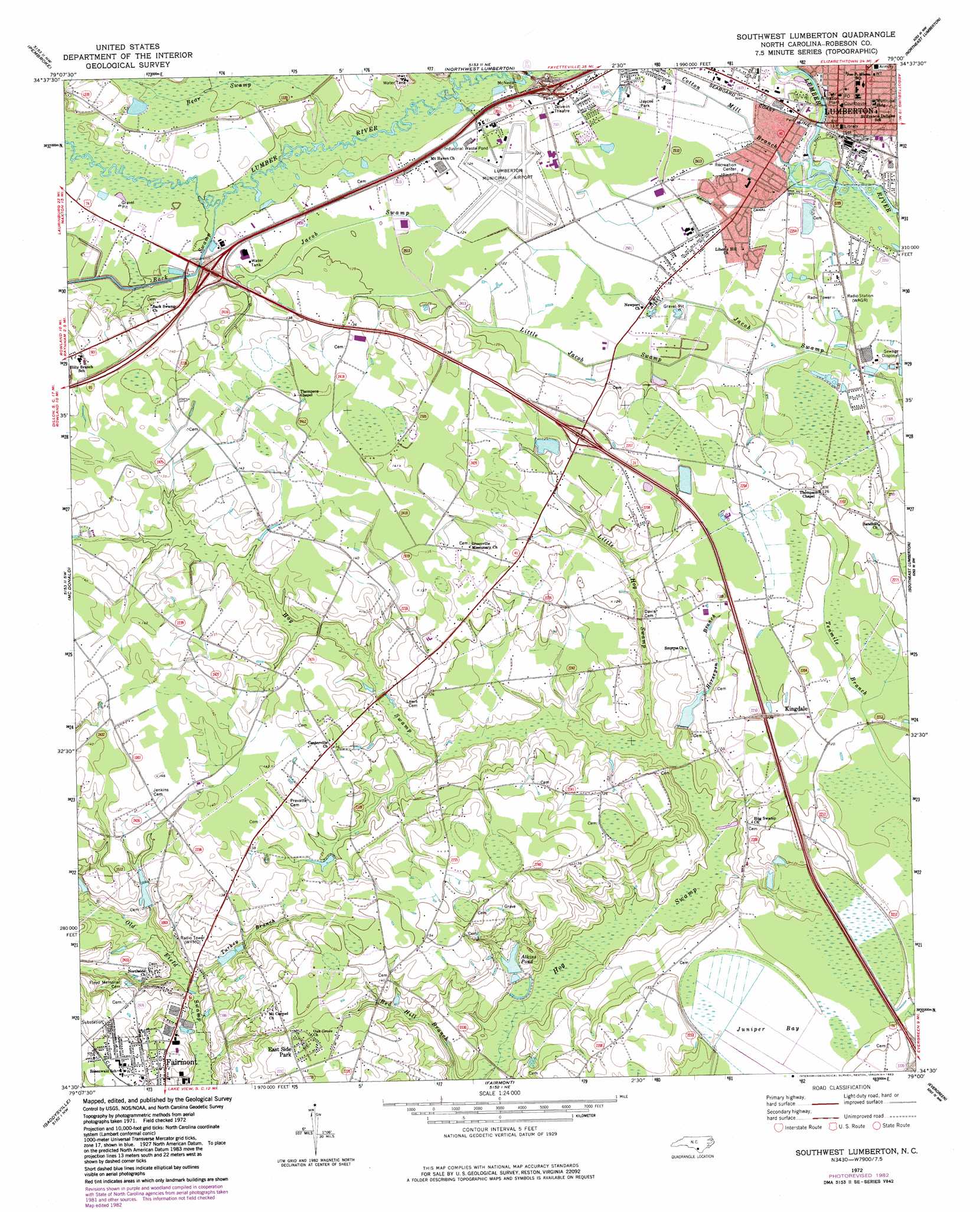
USGS Topo Quad 34079e1 - 1:24,000 scale
| Topo Map Name: | Southwest Lumberton |
| USGS Topo Quad ID: | 34079e1 |
| Print Size: | ca. 21 1/4" wide x 27" high |
| Southeast Coordinates: | 34.5° N latitude / 79° W longitude |
| Map Center Coordinates: | 34.5625° N latitude / 79.0625° W longitude |
| U.S. State: | NC |
| Filename: | o34079e1.jpg |
| Download Map JPG Image: | Southwest Lumberton topo map 1:24,000 scale |
| Map Type: | Topographic |
| Topo Series: | 7.5´ |
| Map Scale: | 1:24,000 |
| Source of Map Images: | United States Geological Survey (USGS) |
| Alternate Map Versions: |
Southwest Lumberton NC 1972, updated 1975 Download PDF Buy paper map Southwest Lumberton NC 1972, updated 1983 Download PDF Buy paper map Southwest Lumberton NC 1976, updated 1976 Download PDF Buy paper map Southwest Lumberton NC 1997, updated 2000 Download PDF Buy paper map Southwest Lumberton NC 2010 Download PDF Buy paper map Southwest Lumberton NC 2013 Download PDF Buy paper map Southwest Lumberton NC 2016 Download PDF Buy paper map |
1:24,000 Topo Quads surrounding Southwest Lumberton
Wakulla |
Red Springs |
Rennert |
Saint Pauls |
Duart |
Maxton |
Pembroke |
Northwest Lumberton |
Northeast Lumberton |
Tar Heel |
Rowland |
Mcdonald |
Southwest Lumberton |
Southeast Lumberton |
Bladenboro |
Dillon East |
Gaddysville |
Fairmont |
Evergreen |
Chadbourn Ne |
Fork |
Lake View |
Fair Bluff |
Cerro Gordo |
Chadbourn |
> Back to 34079e1 at 1:100,000 scale
> Back to 34078a1 at 1:250,000 scale
> Back to U.S. Topo Maps home
Southwest Lumberton topo map: Gazetteer
Southwest Lumberton: Airports
Lumberton Municipal Airport elevation 37m 121′Southwest Lumberton: Bridges
McNeils Bridge elevation 35m 114′Southwest Lumberton: Canals
Gum Branch Canal elevation 35m 114′Southwest Lumberton: Dams
Scarborough Lake Number One Dam elevation 34m 111′Southwest Lumberton: Populated Places
Brittland Mobile Home Park elevation 37m 121′East Side Park elevation 43m 141′
Kingdale elevation 37m 121′
Lumberton elevation 39m 127′
Southwest Lumberton: Reservoirs
Scarborough Lake Number One elevation 34m 111′Southwest Lumberton: Streams
Back Swamp elevation 37m 121′Bear Swamp elevation 36m 118′
Cotton Mill Branch elevation 33m 108′
Horsepen Branch elevation 31m 101′
Jacks Branch elevation 36m 118′
Kersey Branch elevation 38m 124′
Little Jacob Swamp elevation 33m 108′
Turkey Branch elevation 32m 104′
Southwest Lumberton: Swamps
Juniper Bay elevation 36m 118′Little Hog Swamp elevation 35m 114′
Old Field Swamp elevation 31m 101′
Southwest Lumberton digital topo map on disk
Buy this Southwest Lumberton topo map showing relief, roads, GPS coordinates and other geographical features, as a high-resolution digital map file on DVD:
South Carolina, Western North Carolina & Northeastern Georgia
Buy digital topo maps: South Carolina, Western North Carolina & Northeastern Georgia