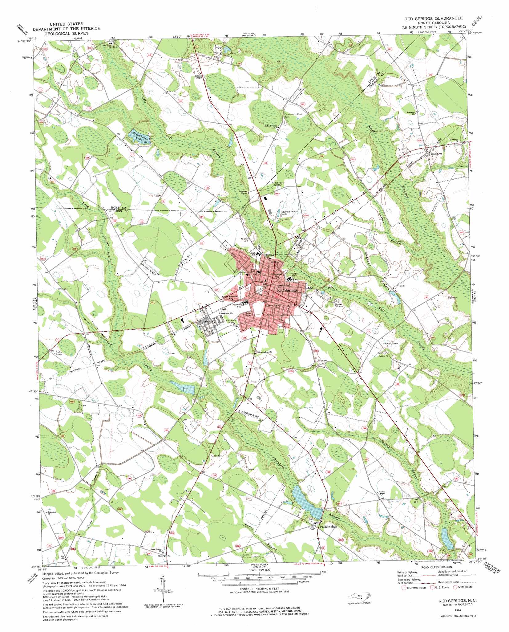
Red Springs Topo Map North Carolina
To zoom in, hover over the map of Red Springs
USGS Topo Quad 34079g2 - 1:24,000 scale
| Topo Map Name: | Red Springs |
| USGS Topo Quad ID: | 34079g2 |
| Print Size: | ca. 21 1/4" wide x 27" high |
| Southeast Coordinates: | 34.75° N latitude / 79.125° W longitude |
| Map Center Coordinates: | 34.8125° N latitude / 79.1875° W longitude |
| U.S. State: | NC |
| Filename: | o34079g2.jpg |
| Download Map JPG Image: | Red Springs topo map 1:24,000 scale |
| Map Type: | Topographic |
| Topo Series: | 7.5´ |
| Map Scale: | 1:24,000 |
| Source of Map Images: | United States Geological Survey (USGS) |
| Alternate Map Versions: |
Red Springs NC 1974, updated 1975 Download PDF Buy paper map Red Springs NC 1974, updated 1975 Download PDF Buy paper map Red Springs NC 1976, updated 1978 Download PDF Buy paper map Red Springs NC 2010 Download PDF Buy paper map Red Springs NC 2013 Download PDF Buy paper map Red Springs NC 2016 Download PDF Buy paper map |
1:24,000 Topo Quads surrounding Red Springs
Pinebluff |
Mccain |
Nicholson Creek |
Clifdale |
Fayetteville |
Silver Hill |
Wagram |
Raeford |
Parkton |
Hope Mills |
Laurinburg |
Wakulla |
Red Springs |
Rennert |
Saint Pauls |
Johns |
Maxton |
Pembroke |
Northwest Lumberton |
Northeast Lumberton |
Minturn |
Rowland |
Mcdonald |
Southwest Lumberton |
Southeast Lumberton |
> Back to 34079e1 at 1:100,000 scale
> Back to 34078a1 at 1:250,000 scale
> Back to U.S. Topo Maps home
Red Springs topo map: Gazetteer
Red Springs: Airports
Confederate Field elevation 59m 193′Red Springs: Dams
Big Buie Pond Dam elevation 50m 164′Buie Pond Dam Small elevation 48m 157′
McNeil Pond Dam elevation 60m 196′
Red Springs: Populated Places
Philadelphus elevation 57m 187′Red Springs elevation 62m 203′
Shannon elevation 61m 200′
Red Springs: Reservoirs
Buie Pond Big elevation 50m 164′Buie Pond Small elevation 48m 157′
Greenbrier Lake elevation 61m 200′
McNeil Pond elevation 60m 196′
Red Springs: Streams
Juniper Branch elevation 51m 167′Long Swamp elevation 58m 190′
McLeans Branch elevation 51m 167′
Red Springs digital topo map on disk
Buy this Red Springs topo map showing relief, roads, GPS coordinates and other geographical features, as a high-resolution digital map file on DVD:
South Carolina, Western North Carolina & Northeastern Georgia
Buy digital topo maps: South Carolina, Western North Carolina & Northeastern Georgia