Ball Ground East Topo Map Georgia
To zoom in, hover over the map of Ball Ground East
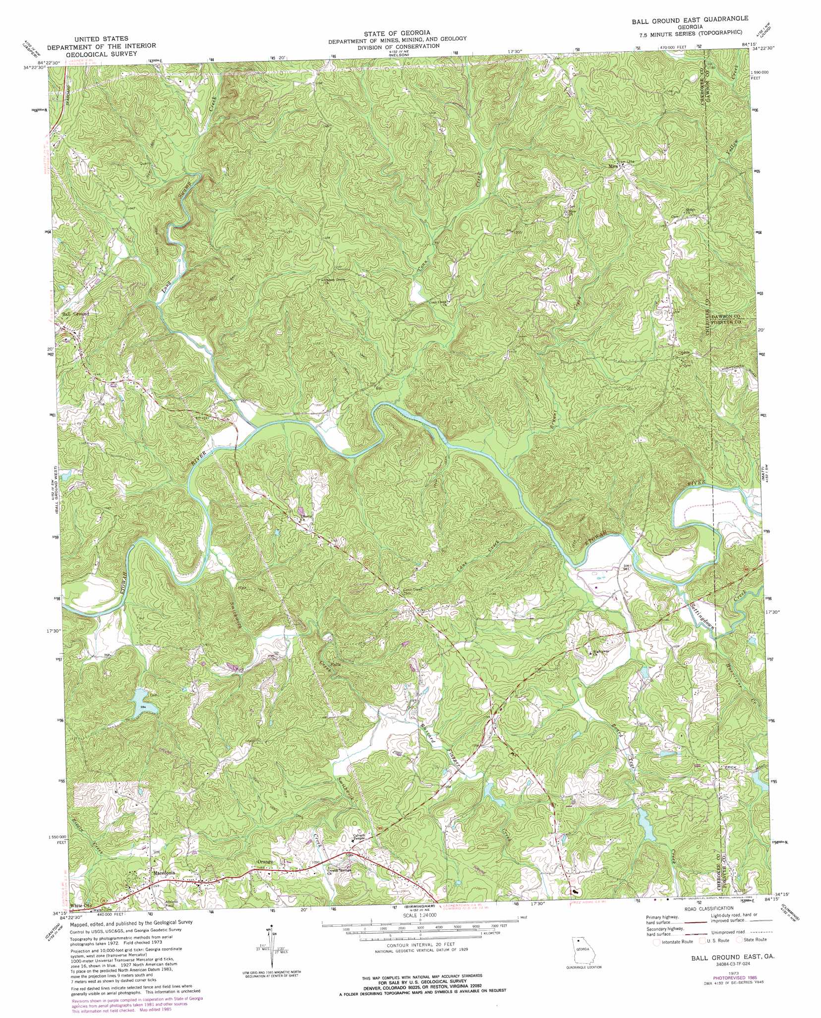
USGS Topo Quad 34084c3 - 1:24,000 scale
| Topo Map Name: | Ball Ground East |
| USGS Topo Quad ID: | 34084c3 |
| Print Size: | ca. 21 1/4" wide x 27" high |
| Southeast Coordinates: | 34.25° N latitude / 84.25° W longitude |
| Map Center Coordinates: | 34.3125° N latitude / 84.3125° W longitude |
| U.S. State: | GA |
| Filename: | o34084c3.jpg |
| Download Map JPG Image: | Ball Ground East topo map 1:24,000 scale |
| Map Type: | Topographic |
| Topo Series: | 7.5´ |
| Map Scale: | 1:24,000 |
| Source of Map Images: | United States Geological Survey (USGS) |
| Alternate Map Versions: |
Ball Ground East GA 1973, updated 1975 Download PDF Buy paper map Ball Ground East GA 1973, updated 1986 Download PDF Buy paper map Ball Ground East GA 1999, updated 2003 Download PDF Buy paper map Ball Ground East GA 2011 Download PDF Buy paper map Ball Ground East GA 2014 Download PDF Buy paper map |
1:24,000 Topo Quads surrounding Ball Ground East
Talking Rock |
Dyke |
Amicalola |
Nimblewill |
Campbell Mountain |
Ludville |
Jasper |
Nelson |
Juno |
Dawsonville |
Waleska |
Ball Ground West |
Ball Ground East |
Matt |
Coal Mountain |
South Canton |
Canton |
Birmingham |
Cumming |
Buford Dam |
Kennesaw |
Mountain Park |
Roswell |
Duluth |
Suwanee |
> Back to 34084a1 at 1:100,000 scale
> Back to 34084a1 at 1:250,000 scale
> Back to U.S. Topo Maps home
Ball Ground East topo map: Gazetteer
Ball Ground East: Dams
Atlanta Gas Light Lake Dam elevation 303m 994′Bartholomew Lake Dam elevation 292m 958′
Mill Canton Structure Number Eight Dam elevation 316m 1036′
Mill Canton Structure Number Three Dam elevation 314m 1030′
Settingdown Creek Structure 27 Dam elevation 321m 1053′
Tustian Lake Dam elevation 358m 1174′
Ball Ground East: Mines
Cherokee Quarry elevation 335m 1099′Franklin Gold Mine elevation 299m 980′
Standard and Swift Mines elevation 312m 1023′
Ball Ground East: Populated Places
Centerville (historical) elevation 327m 1072′Creighton (historical) elevation 330m 1082′
Macedonia elevation 379m 1243′
Mica elevation 409m 1341′
Ophir elevation 360m 1181′
Orange elevation 354m 1161′
Ball Ground East: Reservoirs
Atlanta Gas Light Lake elevation 303m 994′Ball Lake elevation 314m 1030′
Bartholomew Lake elevation 292m 958′
Dean Lake elevation 316m 1036′
Reservoir 27 elevation 321m 1053′
Roberts Lake (historical) elevation 280m 918′
Tustian Lake elevation 358m 1174′
Ball Ground East: Streams
Board Tree Creek elevation 286m 938′Bryant Creek elevation 292m 958′
Buzzard Flapper Creek elevation 298m 977′
Cane Creek elevation 286m 938′
Conn Creek elevation 282m 925′
Hurricane Creek elevation 292m 958′
Long Swamp Creek elevation 280m 918′
Settingdown Creek elevation 292m 958′
Smithwick Creek elevation 279m 915′
Ball Ground East digital topo map on disk
Buy this Ball Ground East topo map showing relief, roads, GPS coordinates and other geographical features, as a high-resolution digital map file on DVD: