Roswell Topo Map Georgia
To zoom in, hover over the map of Roswell
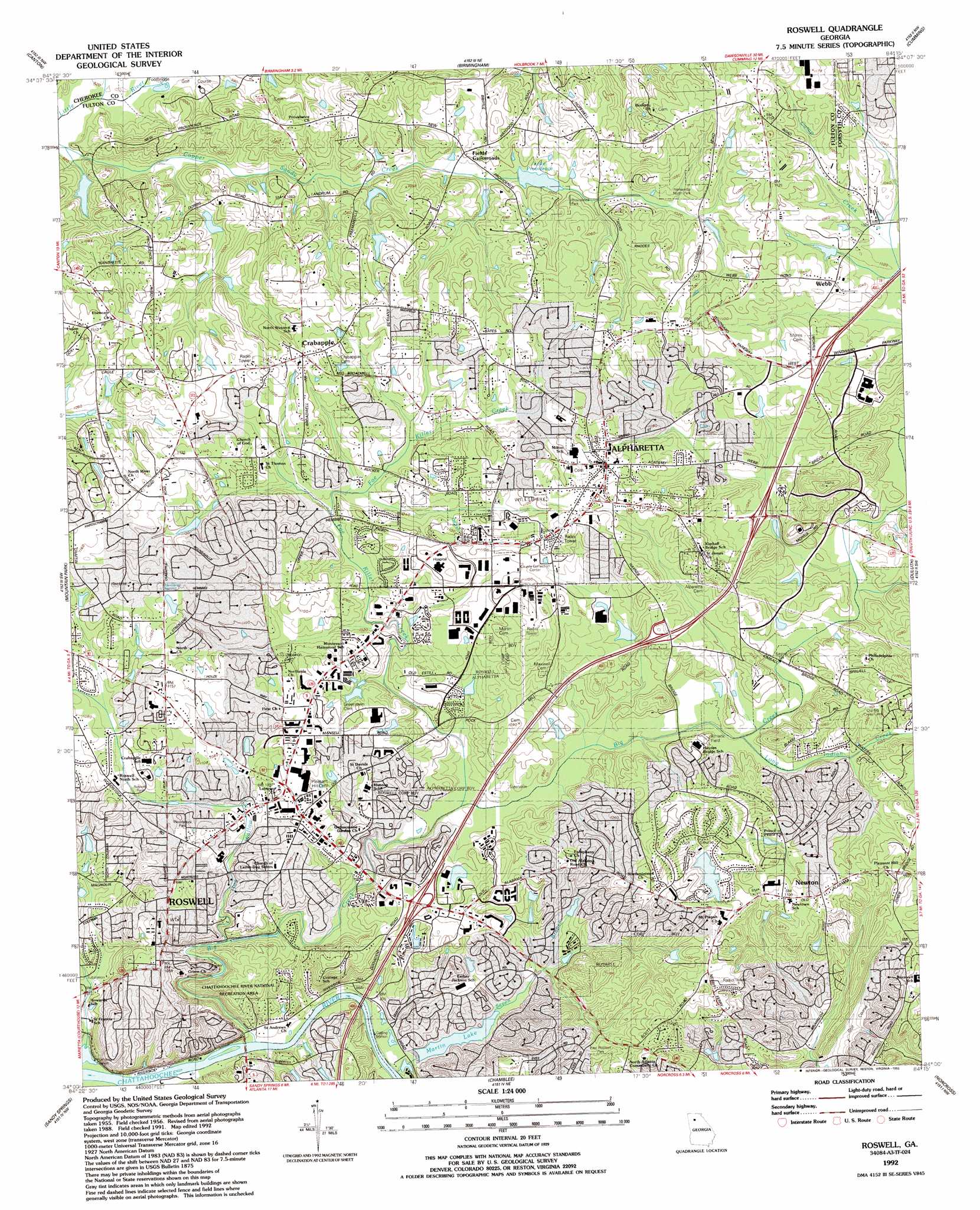
USGS Topo Quad 34084a3 - 1:24,000 scale
| Topo Map Name: | Roswell |
| USGS Topo Quad ID: | 34084a3 |
| Print Size: | ca. 21 1/4" wide x 27" high |
| Southeast Coordinates: | 34° N latitude / 84.25° W longitude |
| Map Center Coordinates: | 34.0625° N latitude / 84.3125° W longitude |
| U.S. State: | GA |
| Filename: | o34084a3.jpg |
| Download Map JPG Image: | Roswell topo map 1:24,000 scale |
| Map Type: | Topographic |
| Topo Series: | 7.5´ |
| Map Scale: | 1:24,000 |
| Source of Map Images: | United States Geological Survey (USGS) |
| Alternate Map Versions: |
Roswell GA 1956, updated 1957 Download PDF Buy paper map Roswell GA 1956, updated 1964 Download PDF Buy paper map Roswell GA 1956, updated 1969 Download PDF Buy paper map Roswell GA 1956, updated 1974 Download PDF Buy paper map Roswell GA 1956, updated 1986 Download PDF Buy paper map Roswell GA 1992, updated 1993 Download PDF Buy paper map Roswell GA 2011 Download PDF Buy paper map Roswell GA 2014 Download PDF Buy paper map |
1:24,000 Topo Quads surrounding Roswell
Waleska |
Ball Ground West |
Ball Ground East |
Matt |
Coal Mountain |
South Canton |
Canton |
Birmingham |
Cumming |
Buford Dam |
Kennesaw |
Mountain Park |
Roswell |
Duluth |
Suwanee |
Marietta |
Sandy Springs |
Chamblee |
Norcross |
Luxomni |
Mableton |
Northwest Atlanta |
Northeast Atlanta |
Stone Mountain |
Snellville |
> Back to 34084a1 at 1:100,000 scale
> Back to 34084a1 at 1:250,000 scale
> Back to U.S. Topo Maps home
Roswell topo map: Gazetteer
Roswell: Airports
Roswell Animal Hospital Heliport elevation 329m 1079′Roswell: Crossings
Martins Ferry (historical) elevation 261m 856′Roswell: Dams
Bartenfeld Dam elevation 281m 921′Copeland Dam elevation 298m 977′
Eads Dam elevation 299m 980′
Lake Arvida Dam elevation 318m 1043′
Martins Landing Lake Dam elevation 271m 889′
Morrison Dam elevation 311m 1020′
Tam O'Shanter Country Club Dam elevation 318m 1043′
Vinson Dam elevation 293m 961′
Roswell: Parks
Alpharetta City Park elevation 340m 1115′Alpharetta North Park elevation 314m 1030′
Centennial High School Football Stadium elevation 333m 1092′
City Square Park elevation 317m 1040′
Providence Park elevation 303m 994′
Roswell Historic District elevation 319m 1046′
Roswell Park elevation 322m 1056′
Veterans Field elevation 333m 1092′
Waller Park elevation 319m 1046′
Wills Park elevation 341m 1118′
Woodstock Park elevation 332m 1089′
Roswell: Populated Places
Alpha Park elevation 338m 1108′Alpharetta elevation 347m 1138′
Andover North elevation 341m 1118′
Country Place elevation 315m 1033′
Crabapple elevation 343m 1125′
Fields Crossroads elevation 311m 1020′
Jamestowne elevation 326m 1069′
Lake Union Hill elevation 324m 1062′
Newtown elevation 343m 1125′
Preston Ridge elevation 311m 1020′
Roswell elevation 329m 1079′
Sterling Heights elevation 318m 1043′
Surrey Place elevation 337m 1105′
Village Green elevation 320m 1049′
Webb elevation 323m 1059′
Wedgewood Forest elevation 325m 1066′
Roswell: Post Offices
Alpharetta Post Office elevation 336m 1102′Holcomb Bridge Post Office elevation 328m 1076′
Roswell Post Office elevation 336m 1102′
Roswell: Reservoirs
Bartenfeld Lake elevation 281m 921′Copeland Lake elevation 298m 977′
Eads Lake elevation 299m 980′
Lake Arrida elevation 318m 1043′
Lake Providence elevation 322m 1056′
Martin Lake elevation 268m 879′
Martins Landing Lake elevation 271m 889′
Morrison Lake elevation 311m 1020′
Tam O'Shanter Country Club Lake elevation 318m 1043′
Vinson Lake elevation 293m 961′
Roswell: Springs
Hembree Spring elevation 347m 1138′Roswell: Streams
Big Creek elevation 260m 853′Chicken Creek elevation 277m 908′
Foe Killer Creek elevation 292m 958′
Hog Wallow Creek elevation 283m 928′
Long Indian Creek elevation 293m 961′
Seven Branch elevation 262m 859′
Roswell digital topo map on disk
Buy this Roswell topo map showing relief, roads, GPS coordinates and other geographical features, as a high-resolution digital map file on DVD: