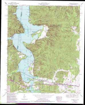
Margerum Topo Map Alabama
To zoom in, hover over the map of Margerum
USGS Topo Quad 34088g1 - 1:24,000 scale
| Topo Map Name: | Margerum |
| USGS Topo Quad ID: | 34088g1 |
| Print Size: | ca. 21 1/4" wide x 27" high |
| Southeast Coordinates: | 34.75° N latitude / 88° W longitude |
| Map Center Coordinates: | 34.8125° N latitude / 88.0625° W longitude |
| U.S. States: | AL, MS |
| Filename: | o34088g1.jpg |
| Download Map JPG Image: | Margerum topo map 1:24,000 scale |
| Map Type: | Topographic |
| Topo Series: | 7.5´ |
| Map Scale: | 1:24,000 |
| Source of Map Images: | United States Geological Survey (USGS) |
| Alternate Map Versions: |
Margerum AL 1936 Download PDF Buy paper map Margerum AL 1953, updated 1958 Download PDF Buy paper map Margerum AL 1953, updated 1972 Download PDF Buy paper map Margerum AL 1953, updated 1977 Download PDF Buy paper map Margerum AL 1953, updated 1985 Download PDF Buy paper map Margerum AL 2011 Download PDF Buy paper map Margerum AL 2014 Download PDF Buy paper map |
1:24,000 Topo Quads surrounding Margerum
> Back to 34088e1 at 1:100,000 scale
> Back to 34088a1 at 1:250,000 scale
> Back to U.S. Topo Maps home
Margerum topo map: Gazetteer
Margerum: Bridges
Buzzard Roost Bridge elevation 134m 439′Free Bridge (historical) elevation 127m 416′
Margerum: Crossings
Fishtrap Ford (historical) elevation 124m 406′Stemeni Ford (historical) elevation 126m 413′
Margerum: Guts
Goose Pond Slough elevation 126m 413′Margerum: Parks
Buzzard Roost Park elevation 128m 419′Colbert County Park elevation 135m 442′
Rosetrail Park elevation 134m 439′
Margerum: Populated Places
Buzzard Roost elevation 142m 465′Caryton (historical) elevation 138m 452′
Chisca elevation 161m 528′
Ingleton (historical) elevation 163m 534′
Lime Kiln elevation 148m 485′
Margerum elevation 140m 459′
Walker (historical) elevation 133m 436′
Margerum: Post Offices
Buzzard Roost Post Office elevation 142m 465′Caryton Post Office (historical) elevation 138m 452′
Ingleton Post Office (historical) elevation 163m 534′
Riverton Junction Post Office elevation 128m 419′
Walker Post Office (historical) elevation 133m 436′
Margerum: Springs
Aurora Spring elevation 134m 439′Bethune Hollow Spring elevation 166m 544′
Buzzard Roost Spring elevation 137m 449′
Culbert Hollow Spring elevation 139m 456′
Hurd Spring elevation 139m 456′
Spout Spring elevation 177m 580′
Margerum: Streams
Booker Branch elevation 125m 410′Browns Creek elevation 135m 442′
Buck Branch elevation 127m 416′
Buzzard Roost Creek elevation 126m 413′
Clear Creek elevation 127m 416′
Lee Branch elevation 126m 413′
Mill Creek elevation 128m 419′
Mill Creek elevation 125m 410′
Moody Branch elevation 133m 436′
Opossum Branch elevation 138m 452′
Pennywinkle Creek elevation 126m 413′
Spring Branch elevation 124m 406′
Margerum: Summits
Bell Quarter Hill elevation 214m 702′Margerum: Valleys
Bethune Hollow elevation 141m 462′Big Spring Hollow elevation 125m 410′
Bone Hollow elevation 167m 547′
Cane Hollow elevation 126m 413′
Cary Hollow elevation 135m 442′
Chalk Mine Hollow elevation 124m 406′
Davis Hollow elevation 167m 547′
Davis Hollow elevation 159m 521′
Doan Hollow elevation 129m 423′
Durbin Ditch elevation 126m 413′
Fish Trap Hollow elevation 124m 406′
Florence Mill Hollow elevation 157m 515′
Geise Hollow elevation 132m 433′
Ginhouse Hollow elevation 128m 419′
Ham Hollow elevation 133m 436′
Hammond Hollow elevation 128m 419′
Happy Hollow elevation 126m 413′
Hayes Hollow elevation 129m 423′
Hurd Hollow elevation 128m 419′
Jones Hollow elevation 162m 531′
Lime Kiln Hollow elevation 134m 439′
Long Hollow elevation 133m 436′
McCabe Hollow elevation 139m 456′
Morgan Hollow elevation 146m 479′
Null Hollow elevation 126m 413′
Opossum Hollow elevation 138m 452′
Shingle Yard Hollow elevation 129m 423′
Shingle Yard Hollow elevation 126m 413′
Smith Hollow elevation 154m 505′
Spencer Hollow elevation 150m 492′
Spencer Hollow elevation 169m 554′
State Line Hollow elevation 127m 416′
State Line Hollow elevation 126m 413′
Sweet Gum Hollow elevation 139m 456′
Thomas Hollow elevation 141m 462′
Upper Field Hollow elevation 125m 410′
Walker Chapel Hollow elevation 142m 465′
Williams Hollow elevation 157m 515′
Wimbish Hollow elevation 126m 413′
Margerum digital topo map on disk
Buy this Margerum topo map showing relief, roads, GPS coordinates and other geographical features, as a high-resolution digital map file on DVD:


