Randolph Topo Map Mississippi
To zoom in, hover over the map of Randolph
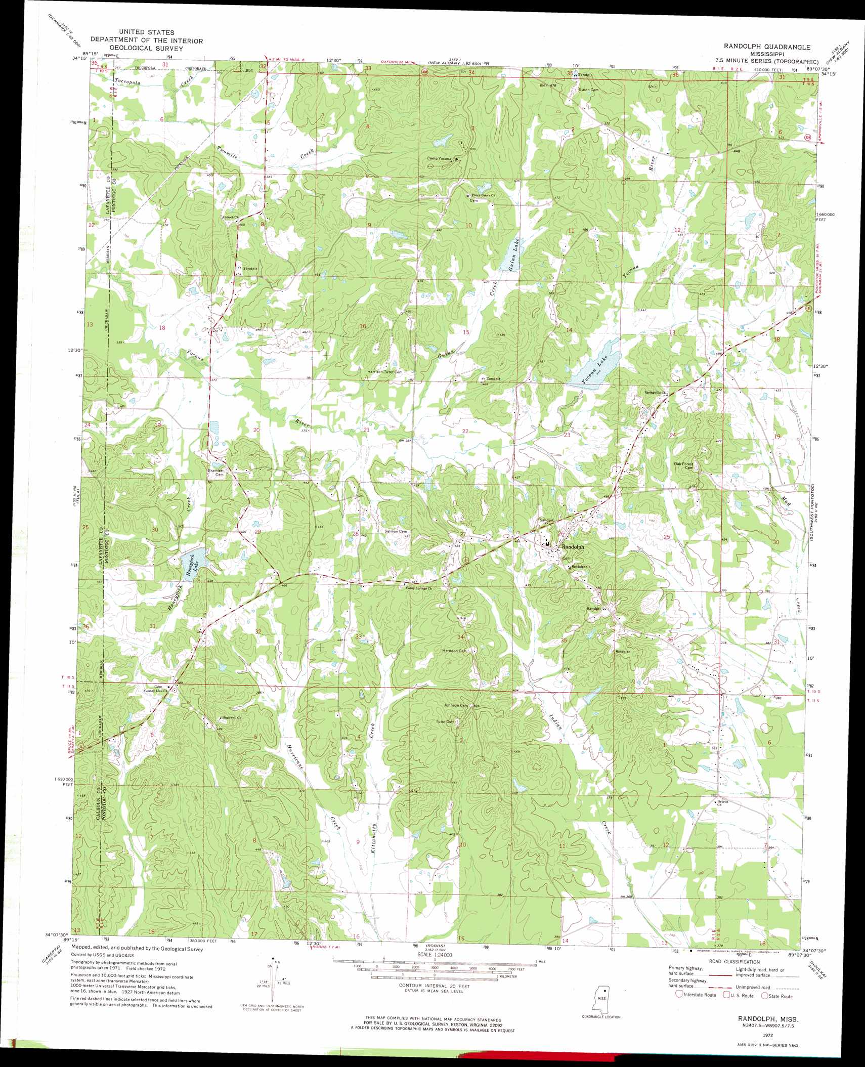
USGS Topo Quad 34089b2 - 1:24,000 scale
| Topo Map Name: | Randolph |
| USGS Topo Quad ID: | 34089b2 |
| Print Size: | ca. 21 1/4" wide x 27" high |
| Southeast Coordinates: | 34.125° N latitude / 89.125° W longitude |
| Map Center Coordinates: | 34.1875° N latitude / 89.1875° W longitude |
| U.S. State: | MS |
| Filename: | o34089b2.jpg |
| Download Map JPG Image: | Randolph topo map 1:24,000 scale |
| Map Type: | Topographic |
| Topo Series: | 7.5´ |
| Map Scale: | 1:24,000 |
| Source of Map Images: | United States Geological Survey (USGS) |
| Alternate Map Versions: |
Randolph MS 1972, updated 1974 Download PDF Buy paper map Randolph MS 2012 Download PDF Buy paper map Randolph MS 2015 Download PDF Buy paper map |
1:24,000 Topo Quads surrounding Randolph
Bagley Lake |
Puskus Lake |
Etta |
New Albany West |
New Albany East |
Yocona |
Denmark |
Thaxton |
Northwest Pontotoc |
Northeast Pontotoc |
Paris |
Tula |
Randolph |
Southwest Pontotoc |
Southeast Pontotoc |
Banner |
Sarepta |
Robbs |
Houlka |
Troy |
Skuna |
Bruce |
Vardaman |
Houston West |
Houston East |
> Back to 34089a1 at 1:100,000 scale
> Back to 34088a1 at 1:250,000 scale
> Back to U.S. Topo Maps home
Randolph topo map: Gazetteer
Randolph: Dams
Andersons Lake Dam elevation 111m 364′Jenkins Lake Dam elevation 149m 488′
Yocana Lake Dam elevation 129m 423′
Yocona River Watershed Y-14-11 Dam elevation 127m 416′
Yocona River Watershed Y-14-12 Dam elevation 122m 400′
Yocona River Watershed Y-14-13 Dam elevation 117m 383′
Randolph: Populated Places
Hebron elevation 116m 380′Randolph elevation 155m 508′
Randolph: Reservoirs
Guinn Lake elevation 128m 419′Honeyfork Lake elevation 122m 400′
Yocona Lake elevation 124m 406′
Randolph: Streams
Guinn Creek elevation 114m 374′Honeyfork Creek elevation 110m 360′
Hurricane Creek elevation 103m 337′
Little Creek elevation 112m 367′
Twomile Creek elevation 109m 357′
Randolph digital topo map on disk
Buy this Randolph topo map showing relief, roads, GPS coordinates and other geographical features, as a high-resolution digital map file on DVD: