New Albany East Topo Map Mississippi
To zoom in, hover over the map of New Albany East
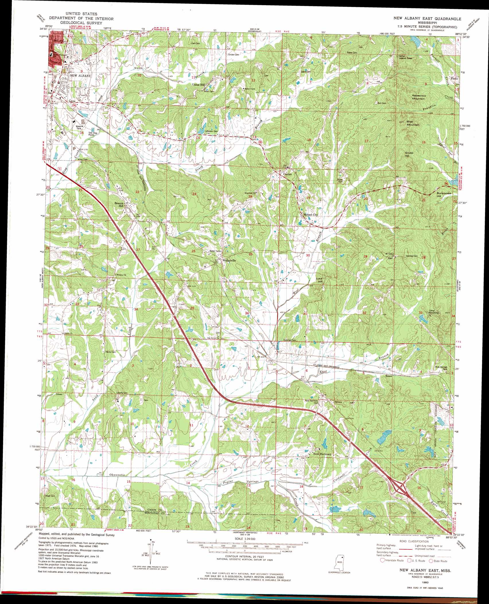
USGS Topo Quad 34088d8 - 1:24,000 scale
| Topo Map Name: | New Albany East |
| USGS Topo Quad ID: | 34088d8 |
| Print Size: | ca. 21 1/4" wide x 27" high |
| Southeast Coordinates: | 34.375° N latitude / 88.875° W longitude |
| Map Center Coordinates: | 34.4375° N latitude / 88.9375° W longitude |
| U.S. State: | MS |
| Filename: | o34088d8.jpg |
| Download Map JPG Image: | New Albany East topo map 1:24,000 scale |
| Map Type: | Topographic |
| Topo Series: | 7.5´ |
| Map Scale: | 1:24,000 |
| Source of Map Images: | United States Geological Survey (USGS) |
| Alternate Map Versions: |
New Albany East MS 1980, updated 1981 Download PDF Buy paper map New Albany East MS 2012 Download PDF Buy paper map New Albany East MS 2015 Download PDF Buy paper map |
1:24,000 Topo Quads surrounding New Albany East
Chilli Creek |
Blue Mountain |
Ripley |
Dumas |
Jumpertown |
Hickory Flat |
Myrtle |
Keownville |
Pleasant Ridge |
Baldwyn |
Etta |
New Albany West |
New Albany East |
Ellistown |
Guntown |
Thaxton |
Northwest Pontotoc |
Northeast Pontotoc |
Sherman |
Tupelo |
Randolph |
Southwest Pontotoc |
Southeast Pontotoc |
Bissell |
Verona |
> Back to 34088a1 at 1:100,000 scale
> Back to 34088a1 at 1:250,000 scale
> Back to U.S. Topo Maps home
New Albany East topo map: Gazetteer
New Albany East: Dams
Carnell Lake Dam elevation 112m 367′Lake Lynda Dam elevation 152m 498′
Long Lake Dam elevation 136m 446′
Newtons Lake Dam elevation 134m 439′
Okonatie Watershed UT-25-2 Dam elevation 132m 433′
Ralph Harris Pond Dam elevation 139m 456′
New Albany East: Gaps
Blue Cut elevation 146m 479′New Albany East: Populated Places
Beacon Hill elevation 149m 488′Center elevation 172m 564′
Mound City elevation 140m 459′
New Harmony elevation 147m 482′
Parks elevation 137m 449′
Reese elevation 135m 442′
Union Hill elevation 154m 505′
Wallerville elevation 166m 544′
New Albany East: Post Offices
Fairview Post Office (historical) elevation 142m 465′New Albany East: Reservoirs
Lake Lynda elevation 135m 442′New Albany East: Streams
Caldwell Creek elevation 117m 383′East Branch Okannatie Creek elevation 117m 383′
North Branch King Creek elevation 110m 360′
Poplar Springs Creek elevation 110m 360′
Popular Springs Creek elevation 110m 360′
South Branch King Creek elevation 110m 360′
West Branch Okannatie Creek elevation 117m 383′
New Albany East: Summits
Briar Mountain elevation 193m 633′Buncombe Hill elevation 151m 495′
Grubb Hill elevation 194m 636′
Luke Hill elevation 159m 521′
Rakestraw Mountain elevation 175m 574′
New Albany East digital topo map on disk
Buy this New Albany East topo map showing relief, roads, GPS coordinates and other geographical features, as a high-resolution digital map file on DVD: