Indian Bay Se Topo Map Arkansas
To zoom in, hover over the map of Indian Bay Se
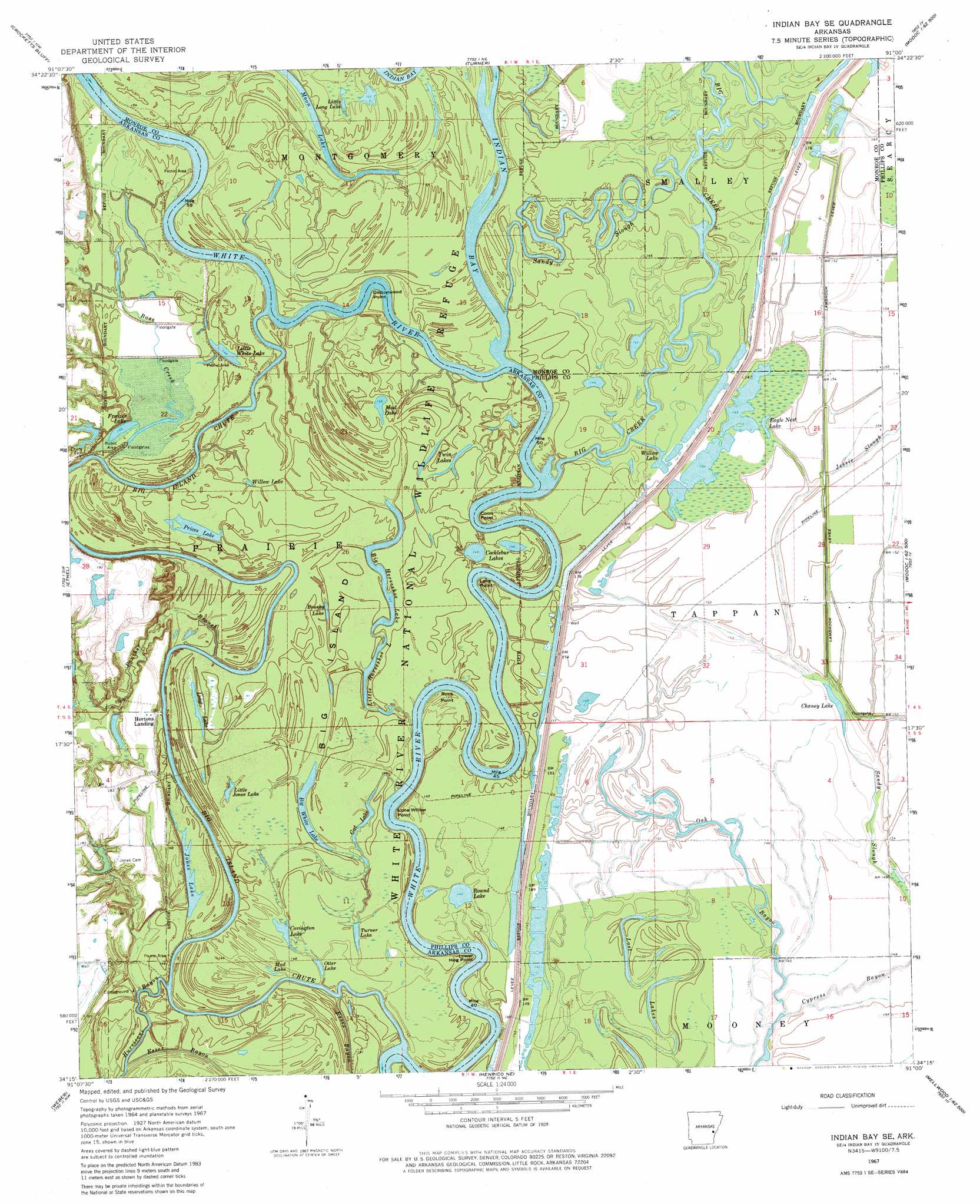
USGS Topo Quad 34091c1 - 1:24,000 scale
| Topo Map Name: | Indian Bay Se |
| USGS Topo Quad ID: | 34091c1 |
| Print Size: | ca. 21 1/4" wide x 27" high |
| Southeast Coordinates: | 34.25° N latitude / 91° W longitude |
| Map Center Coordinates: | 34.3125° N latitude / 91.0625° W longitude |
| U.S. State: | AR |
| Filename: | o34091c1.jpg |
| Download Map JPG Image: | Indian Bay Se topo map 1:24,000 scale |
| Map Type: | Topographic |
| Topo Series: | 7.5´ |
| Map Scale: | 1:24,000 |
| Source of Map Images: | United States Geological Survey (USGS) |
| Alternate Map Versions: |
Indian Bay SE AR 1967, updated 1968 Download PDF Buy paper map Indian Bay SE AR 1967, updated 1981 Download PDF Buy paper map Indian Bay SE AR 1967, updated 1981 Download PDF Buy paper map Indian Bay SE AR 2011 Download PDF Buy paper map Indian Bay SE AR 2014 Download PDF Buy paper map |
1:24,000 Topo Quads surrounding Indian Bay Se
Aberdeen |
Holly Grove |
Pine City |
Marvell |
Lexa |
De Witt Ne |
Crocketts Bluff |
Turner |
Watkins Corner |
Lakeview |
De Witt |
Ethel |
Indian Bay Se |
Lambrook |
Elaine |
Tichnor |
Weber |
Henrico Ne |
Mellwood |
Rena Lara |
Arkansas Post |
Henrico Sw |
Snow Lake |
Laconia |
Round Lake |
> Back to 34091a1 at 1:100,000 scale
> Back to 34090a1 at 1:250,000 scale
> Back to U.S. Topo Maps home
Indian Bay Se topo map: Gazetteer
Indian Bay Se: Bends
Hughes Bend elevation 43m 141′Raft Bend elevation 43m 141′
Indian Bay Se: Capes
Coon Point elevation 45m 147′Cottonwood Point elevation 43m 141′
Lake Point elevation 48m 157′
Lone Willow Point elevation 43m 141′
Lower Hog Point elevation 45m 147′
Rock Point elevation 47m 154′
Indian Bay Se: Dams
Horton Lake Dam elevation 51m 167′Jones Lake Dam elevation 50m 164′
Pike Pond Dam elevation 50m 164′
Indian Bay Se: Flats
Big Island elevation 45m 147′Indian Bay Se: Guts
Big Island Chute elevation 43m 141′Hurricane Bayou elevation 45m 147′
Sandy Slough elevation 46m 150′
Sandy Slough elevation 45m 147′
Indian Bay Se: Lakes
Big Horseshoe Lake elevation 47m 154′Big White Lake elevation 43m 141′
Brushy Lake elevation 46m 150′
Chaney Lake elevation 45m 147′
Cocklebur Lakes elevation 46m 150′
Covington Lake elevation 45m 147′
Eagle Nest Lake elevation 45m 147′
Frazier Lake elevation 47m 154′
Gut Lake elevation 44m 144′
Little Horseshoe Lake elevation 44m 144′
Little Jones Lake elevation 45m 147′
Little Long Lake elevation 45m 147′
Little White Lake elevation 43m 141′
Long Lake elevation 45m 147′
Lost Lakes elevation 45m 147′
Moon Lake elevation 43m 141′
Mud Lake elevation 45m 147′
Mud Lake elevation 45m 147′
Otter Lake elevation 45m 147′
Prices Lake elevation 46m 150′
Round Lake elevation 46m 150′
Turner Lake elevation 45m 147′
Twin Lakes elevation 46m 150′
Willow Lake elevation 44m 144′
Willow Lake elevation 46m 150′
Indian Bay Se: Levees
Lambrook Levee elevation 46m 150′Indian Bay Se: Parks
White River National Wildlife Refuge elevation 46m 150′Indian Bay Se: Populated Places
Cowpens (historical) elevation 48m 157′Hortons Landing elevation 50m 164′
Indian Bay Se: Reservoirs
Horton Lake elevation 51m 167′Jones Lake elevation 50m 164′
Pike Pond elevation 50m 164′
Indian Bay Se: Streams
Bass Creek elevation 44m 144′Big Creek elevation 43m 141′
Indian Bay elevation 43m 141′
Jessie Slough elevation 45m 147′
Oak Bayou elevation 46m 150′
Panther Branch elevation 42m 137′
Prairie Cypress Creek elevation 44m 144′
Indian Bay Se digital topo map on disk
Buy this Indian Bay Se topo map showing relief, roads, GPS coordinates and other geographical features, as a high-resolution digital map file on DVD: