Adamson Topo Map Oklahoma
To zoom in, hover over the map of Adamson
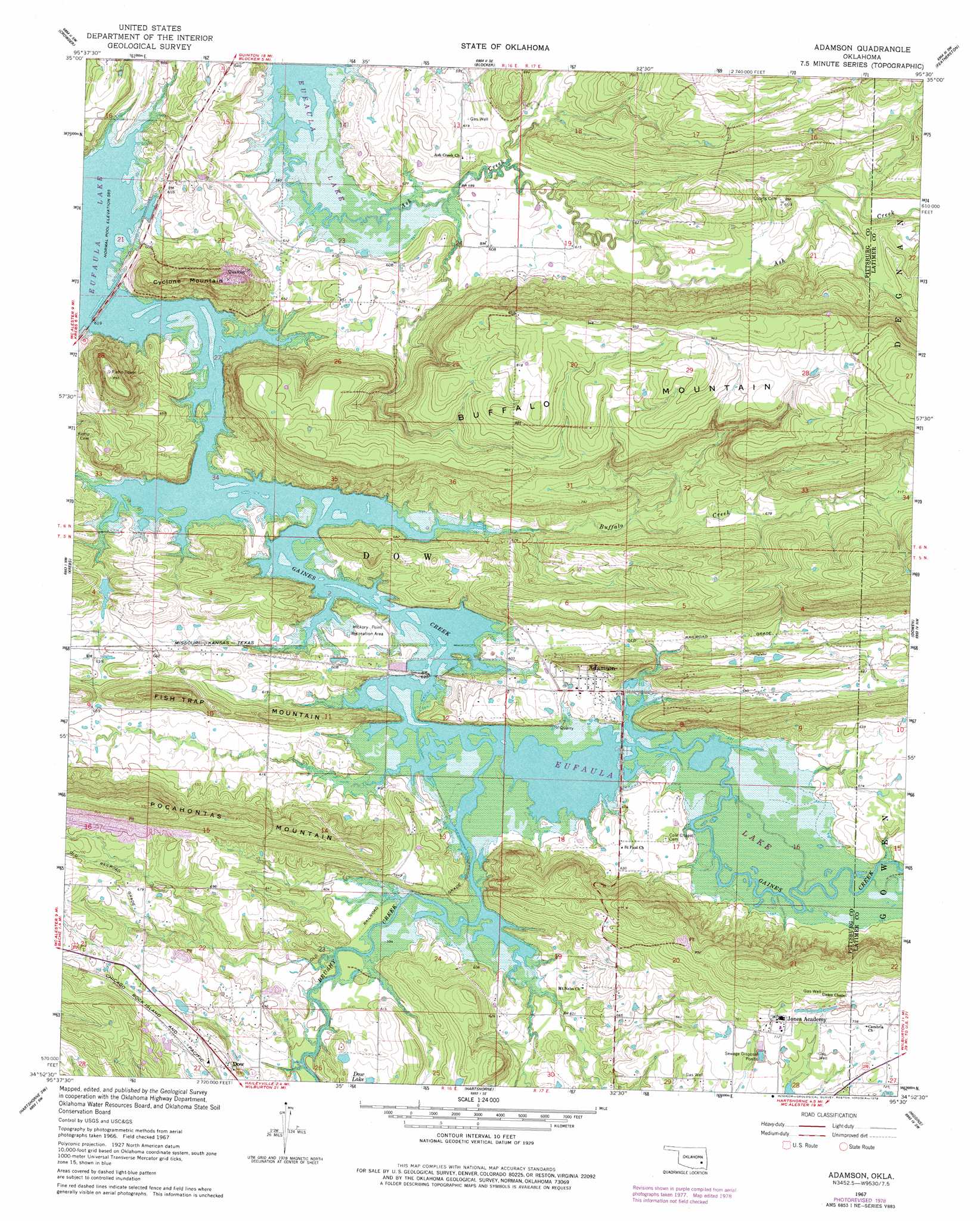
USGS Topo Quad 34095h5 - 1:24,000 scale
| Topo Map Name: | Adamson |
| USGS Topo Quad ID: | 34095h5 |
| Print Size: | ca. 21 1/4" wide x 27" high |
| Southeast Coordinates: | 34.875° N latitude / 95.5° W longitude |
| Map Center Coordinates: | 34.9375° N latitude / 95.5625° W longitude |
| U.S. State: | OK |
| Filename: | o34095h5.jpg |
| Download Map JPG Image: | Adamson topo map 1:24,000 scale |
| Map Type: | Topographic |
| Topo Series: | 7.5´ |
| Map Scale: | 1:24,000 |
| Source of Map Images: | United States Geological Survey (USGS) |
| Alternate Map Versions: |
Adamson OK 1967, updated 1968 Download PDF Buy paper map Adamson OK 1967, updated 1978 Download PDF Buy paper map Adamson OK 2010 Download PDF Buy paper map Adamson OK 2012 Download PDF Buy paper map Adamson OK 2016 Download PDF Buy paper map |
1:24,000 Topo Quads surrounding Adamson
Indianola |
Canadian |
Longtown |
Enterprise |
Quinton North |
Lake Mcalester |
Crowder |
Blocker |
Featherston |
Quinton South |
Mcalester |
Krebs |
Adamson |
Gowen |
Wilburton |
Savanna |
Hartshorne Sw |
Hartshorne |
Higgins |
Damon |
Pittsburg |
Ti |
Counts |
Sardis |
Yanush |
> Back to 34095e1 at 1:100,000 scale
> Back to 34094a1 at 1:250,000 scale
> Back to U.S. Topo Maps home
Adamson topo map: Gazetteer
Adamson: Dams
Jones Lake Dam elevation 209m 685′Oknoname 121019 Dam elevation 186m 610′
Adamson: Parks
Hickory Point Recreation Area elevation 186m 610′Adamson: Populated Places
Adamson elevation 189m 620′Dow elevation 195m 639′
Adamson: Reservoirs
Jones Lake elevation 209m 685′Oknoname 121019 Reservoir elevation 186m 610′
Adamson: Streams
Ash Creek elevation 178m 583′Brushy Creek elevation 179m 587′
Buffalo Creek elevation 178m 583′
Gaines Creek elevation 178m 583′
Adamson: Summits
Buffalo Mountain elevation 300m 984′Cyclone Mountain elevation 243m 797′
Fish Trap Mountain elevation 248m 813′
Pocahontas Mountain elevation 278m 912′
Adamson digital topo map on disk
Buy this Adamson topo map showing relief, roads, GPS coordinates and other geographical features, as a high-resolution digital map file on DVD: