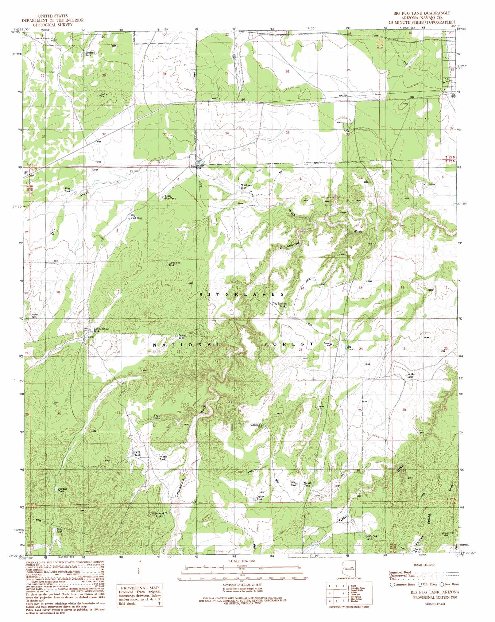
Big Pug Tank Topo Map Arizona
To zoom in, hover over the map of Big Pug Tank
USGS Topo Quad 34110d3 - 1:24,000 scale
| Topo Map Name: | Big Pug Tank |
| USGS Topo Quad ID: | 34110d3 |
| Print Size: | ca. 21 1/4" wide x 27" high |
| Southeast Coordinates: | 34.375° N latitude / 110.25° W longitude |
| Map Center Coordinates: | 34.4375° N latitude / 110.3125° W longitude |
| U.S. State: | AZ |
| Filename: | o34110d3.jpg |
| Download Map JPG Image: | Big Pug Tank topo map 1:24,000 scale |
| Map Type: | Topographic |
| Topo Series: | 7.5´ |
| Map Scale: | 1:24,000 |
| Source of Map Images: | United States Geological Survey (USGS) |
| Alternate Map Versions: |
Big Pug Tank AZ 1990, updated 1991 Download PDF Buy paper map Big Pug Tank AZ 1998, updated 2000 Download PDF Buy paper map Big Pug Tank AZ 2011 Download PDF Buy paper map Big Pug Tank AZ 2014 Download PDF Buy paper map |
| FStopo: | US Forest Service topo Big Pug Tank is available: Download FStopo PDF Download FStopo TIF |
1:24,000 Topo Quads surrounding Big Pug Tank
Potato Wash Ne |
Dry Lake Nw |
Dry Lake Ne |
Flattop Hill |
Tenmile Cedars |
Red Knoll |
Zeniff |
Sheepskin Wash |
Second Knolls |
Snowflake |
Heber |
Aripine |
Big Pug Tank |
Cactus Flat |
Taylor |
Outlaw Draw |
Day Spring |
Clay Springs |
Pinedale |
Show Low North |
Pepper Canyon |
Bear Ridge |
Limestone Canyon North |
Red Top Mountain |
Show Low South |
> Back to 34110a1 at 1:100,000 scale
> Back to 34110a1 at 1:250,000 scale
> Back to U.S. Topo Maps home
Big Pug Tank topo map: Gazetteer
Big Pug Tank: Lakes
Walker Lake elevation 1866m 6122′Big Pug Tank: Reservoirs
Big Pug Tank elevation 1876m 6154′Big Tank elevation 1864m 6115′
Clay Springs Tank elevation 1874m 6148′
Cottonwood Number Two Tank elevation 1914m 6279′
Dalton Tank elevation 1909m 6263′
Dry Tank elevation 1917m 6289′
Government Tank elevation 1854m 6082′
Gressey Tank elevation 1862m 6108′
Hidden Tank elevation 1962m 6437′
Holy Oak Tank elevation 1902m 6240′
Kays Tank elevation 1975m 6479′
Little Pug Tank elevation 1866m 6122′
Long Hollow Tank elevation 1903m 6243′
Max Tank elevation 1920m 6299′
Middle Tank elevation 1915m 6282′
Northwest Tank elevation 1846m 6056′
Pine Tank elevation 1922m 6305′
Section Twenty-seven Tank elevation 1914m 6279′
Swale Tank elevation 1902m 6240′
Thomas Tank elevation 1917m 6289′
Winter Tank elevation 1900m 6233′
Woodland Tank elevation 1872m 6141′
XIL Tank elevation 1914m 6279′
Big Pug Tank: Streams
Day Wash elevation 1823m 5980′Big Pug Tank: Wells
Town Well elevation 1885m 6184′Big Pug Tank digital topo map on disk
Buy this Big Pug Tank topo map showing relief, roads, GPS coordinates and other geographical features, as a high-resolution digital map file on DVD: