Cactus Flat Topo Map Arizona
To zoom in, hover over the map of Cactus Flat
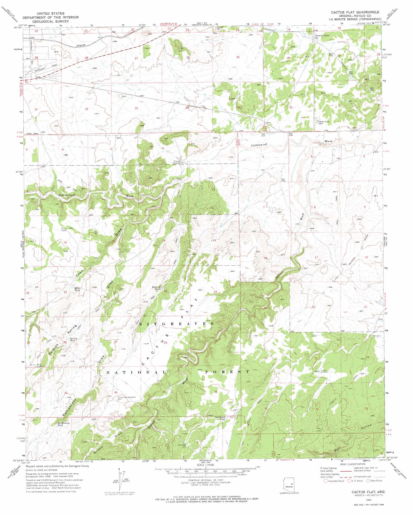
USGS Topo Quad 34110d2 - 1:24,000 scale
| Topo Map Name: | Cactus Flat |
| USGS Topo Quad ID: | 34110d2 |
| Print Size: | ca. 21 1/4" wide x 27" high |
| Southeast Coordinates: | 34.375° N latitude / 110.125° W longitude |
| Map Center Coordinates: | 34.4375° N latitude / 110.1875° W longitude |
| U.S. State: | AZ |
| Filename: | o34110d2.jpg |
| Download Map JPG Image: | Cactus Flat topo map 1:24,000 scale |
| Map Type: | Topographic |
| Topo Series: | 7.5´ |
| Map Scale: | 1:24,000 |
| Source of Map Images: | United States Geological Survey (USGS) |
| Alternate Map Versions: |
Cactus Flat AZ 1970, updated 1973 Download PDF Buy paper map Cactus Flat AZ 1970, updated 1973 Download PDF Buy paper map Cactus Flat AZ 1998, updated 2000 Download PDF Buy paper map Cactus Flat AZ 2011 Download PDF Buy paper map Cactus Flat AZ 2014 Download PDF Buy paper map |
| FStopo: | US Forest Service topo Cactus Flat is available: Download FStopo PDF Download FStopo TIF |
1:24,000 Topo Quads surrounding Cactus Flat
Dry Lake Nw |
Dry Lake Ne |
Flattop Hill |
Tenmile Cedars |
Hay Hollow |
Zeniff |
Sheepskin Wash |
Second Knolls |
Snowflake |
Point Of The Mountain |
Aripine |
Big Pug Tank |
Cactus Flat |
Taylor |
Mesa Redonda Nw |
Day Spring |
Clay Springs |
Pinedale |
Show Low North |
Silver Springs |
Bear Ridge |
Limestone Canyon North |
Red Top Mountain |
Show Low South |
Lakeside |
> Back to 34110a1 at 1:100,000 scale
> Back to 34110a1 at 1:250,000 scale
> Back to U.S. Topo Maps home
Cactus Flat topo map: Gazetteer
Cactus Flat: Arroyos
Mortensen Wash elevation 1750m 5741′Cactus Flat: Flats
Cactus Flat elevation 1860m 6102′Cactus Flat: Reservoirs
Antelope Tank elevation 1825m 5987′Back Stop Tank elevation 1809m 5935′
Ballard Tank elevation 1833m 6013′
Carlisle Tank elevation 1834m 6017′
Deborah Tank elevation 1805m 5921′
Drinker Tank elevation 1869m 6131′
Drinker Tank elevation 1869m 6131′
Miller Tank elevation 1818m 5964′
Northeast Tank elevation 1866m 6122′
Number Two Tank elevation 1859m 6099′
Rattlesnake Tank elevation 1890m 6200′
Spring Tank elevation 1848m 6062′
Thomas Tank elevation 1755m 5757′
Cactus Flat: Streams
Dodson Wash elevation 1740m 5708′Cactus Flat: Valleys
Bull Ranch Draw elevation 1792m 5879′Perkins Spring Draw elevation 1785m 5856′
Rattlesnake Draw elevation 1811m 5941′
Town Draw elevation 1765m 5790′
Wilson Draw elevation 1849m 6066′
Cactus Flat: Wells
East Well elevation 1910m 6266′Cactus Flat digital topo map on disk
Buy this Cactus Flat topo map showing relief, roads, GPS coordinates and other geographical features, as a high-resolution digital map file on DVD: