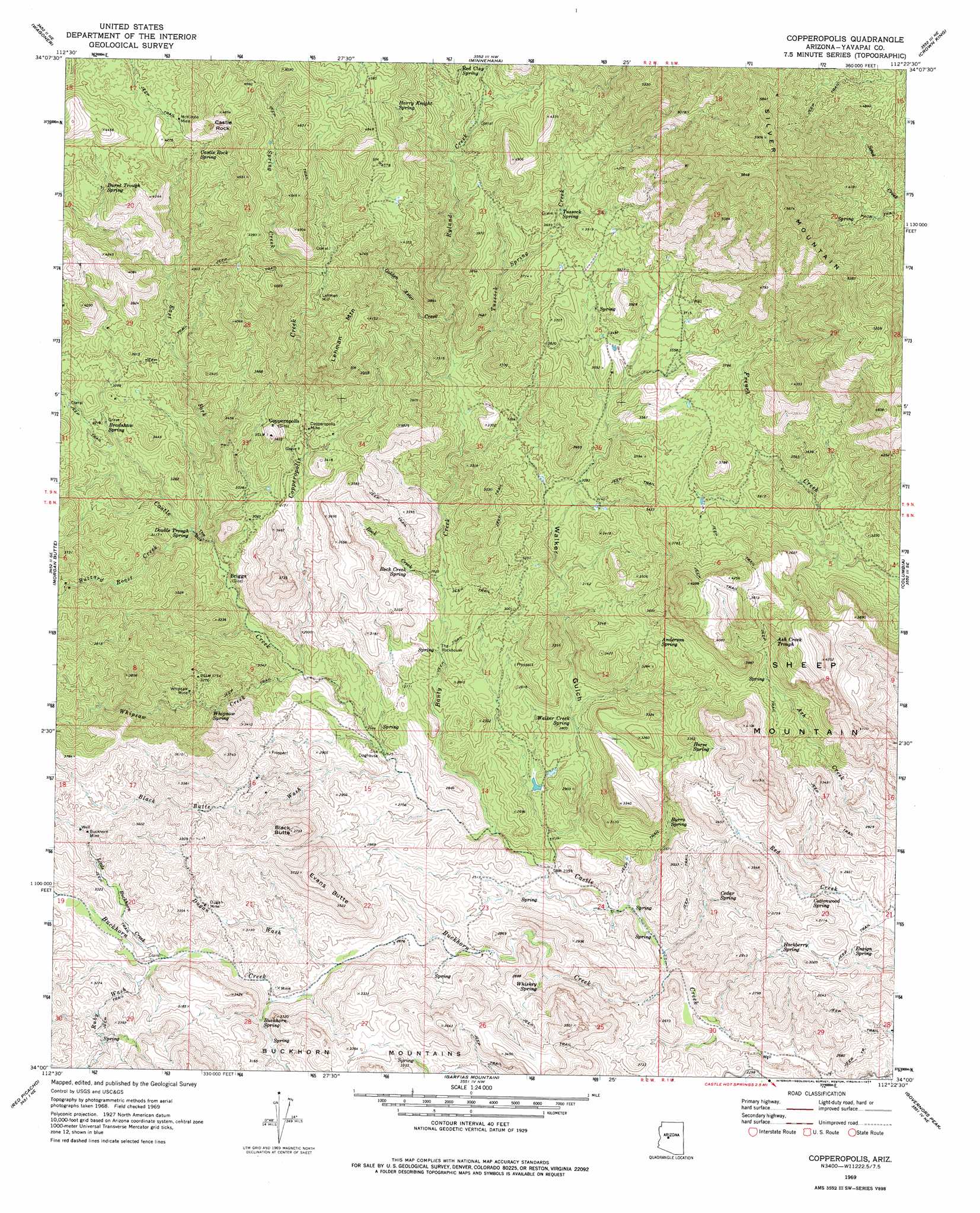
Copperopolis Topo Map Arizona
To zoom in, hover over the map of Copperopolis
USGS Topo Quad 34112a4 - 1:24,000 scale
| Topo Map Name: | Copperopolis |
| USGS Topo Quad ID: | 34112a4 |
| Print Size: | ca. 21 1/4" wide x 27" high |
| Southeast Coordinates: | 34° N latitude / 112.375° W longitude |
| Map Center Coordinates: | 34.0625° N latitude / 112.4375° W longitude |
| U.S. State: | AZ |
| Filename: | o34112a4.jpg |
| Download Map JPG Image: | Copperopolis topo map 1:24,000 scale |
| Map Type: | Topographic |
| Topo Series: | 7.5´ |
| Map Scale: | 1:24,000 |
| Source of Map Images: | United States Geological Survey (USGS) |
| Alternate Map Versions: |
Copperopolis AZ 1969, updated 1972 Download PDF Buy paper map Copperopolis AZ 1969, updated 1977 Download PDF Buy paper map Copperopolis AZ 1969, updated 1977 Download PDF Buy paper map Copperopolis AZ 2011 Download PDF Buy paper map Copperopolis AZ 2014 Download PDF Buy paper map |
| FStopo: | US Forest Service topo Copperopolis is available: Download FStopo PDF Download FStopo TIF |
1:24,000 Topo Quads surrounding Copperopolis
Peeples Valley |
Walnut Grove |
Battleship Butte |
Battle Flat |
Cleator |
Yarnell |
Wagoner |
Minnehaha |
Crown King |
Bumble Bee |
Sam Powell Peak |
Morgan Butte |
Copperopolis |
Columbia |
Black Canyon City |
Wickenburg |
Red Picacho |
Garfias Mountain |
Governors Peak |
New River |
Wickenburg Sw |
Wittmann |
Hieroglyphic Mountains Sw |
Baldy Mountain |
Biscuit Flat |
> Back to 34112a1 at 1:100,000 scale
> Back to 34112a1 at 1:250,000 scale
> Back to U.S. Topo Maps home
Copperopolis topo map: Gazetteer
Copperopolis: Bends
The Box elevation 862m 2828′Copperopolis: Mines
Buckhorn Mine elevation 997m 3270′Copperopolis Mine elevation 978m 3208′
Dugan Mine elevation 956m 3136′
McKinzie Mine elevation 1280m 4199′
Whipsaw Mine elevation 928m 3044′
Copperopolis: Pillars
Castle Rock elevation 1419m 4655′The Doghouse elevation 771m 2529′
The Rockhouse elevation 819m 2687′
Copperopolis: Populated Places
Briggs elevation 841m 2759′Copperopolis elevation 1023m 3356′
Lehman Mill elevation 1172m 3845′
Copperopolis: Reservoirs
Ash Creek Trough elevation 1081m 3546′Copperopolis: Springs
Anderson Spring elevation 1003m 3290′Bradshaw Spring elevation 963m 3159′
Buckhorn Spring elevation 872m 2860′
Burnt Trough Spring elevation 1224m 4015′
Burro Spring elevation 813m 2667′
Castle Rock Spring elevation 1243m 4078′
Cedar Spring elevation 811m 2660′
Cottonwood Spring elevation 853m 2798′
Double Trough Spring elevation 867m 2844′
Ensign Spring elevation 832m 2729′
Hackberry Spring elevation 838m 2749′
Harry Knight Spring elevation 1321m 4333′
Horse Spring elevation 956m 3136′
Red Clay Spring elevation 1238m 4061′
Rock Creek Spring elevation 865m 2837′
Tussock Spring elevation 1133m 3717′
Walker Creek Spring elevation 804m 2637′
Whipsaw Spring elevation 902m 2959′
Whiskey Spring elevation 782m 2565′
Copperopolis: Streams
Banty Creek elevation 735m 2411′Black Butte Wash elevation 765m 2509′
Buckhorn Creek elevation 696m 2283′
Buzzard Roost Creek elevation 862m 2828′
Copperopolis Creek elevation 802m 2631′
Dugan Wash elevation 834m 2736′
East Fork Castle Creek elevation 866m 2841′
Golden Aster Creek elevation 970m 3182′
Little Buckhorn Creek elevation 895m 2936′
Rock Creek elevation 831m 2726′
Ruby Wash elevation 0m 0′
Ryland Creek elevation 948m 3110′
Spring Creek elevation 1172m 3845′
Tussock Spring Creek elevation 944m 3097′
Whipsaw Creek elevation 802m 2631′
Copperopolis: Summits
Black Butte elevation 1127m 3697′Evans Butte elevation 1136m 3727′
Lehman Mountain elevation 1318m 4324′
Sheep Mountain elevation 0m 0′
Thoma Butte elevation 1138m 3733′
Copperopolis: Valleys
Walker Gulch elevation 723m 2372′Copperopolis digital topo map on disk
Buy this Copperopolis topo map showing relief, roads, GPS coordinates and other geographical features, as a high-resolution digital map file on DVD: