Battle Flat Topo Map Arizona
To zoom in, hover over the map of Battle Flat
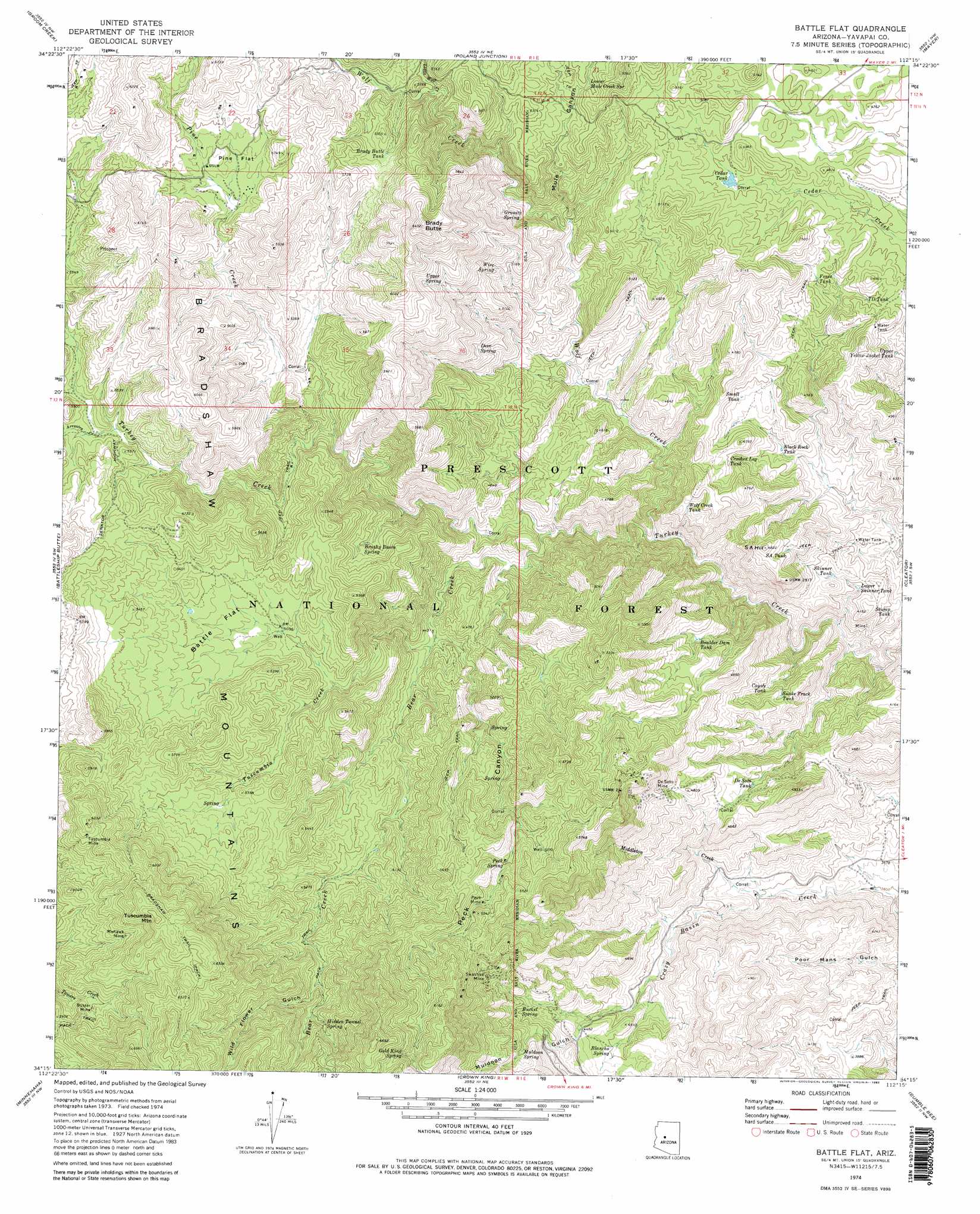
USGS Topo Quad 34112c3 - 1:24,000 scale
| Topo Map Name: | Battle Flat |
| USGS Topo Quad ID: | 34112c3 |
| Print Size: | ca. 21 1/4" wide x 27" high |
| Southeast Coordinates: | 34.25° N latitude / 112.25° W longitude |
| Map Center Coordinates: | 34.3125° N latitude / 112.3125° W longitude |
| U.S. State: | AZ |
| Filename: | o34112c3.jpg |
| Download Map JPG Image: | Battle Flat topo map 1:24,000 scale |
| Map Type: | Topographic |
| Topo Series: | 7.5´ |
| Map Scale: | 1:24,000 |
| Source of Map Images: | United States Geological Survey (USGS) |
| Alternate Map Versions: |
Battle Flat AZ 1974, updated 1977 Download PDF Buy paper map Battle Flat AZ 1974, updated 1982 Download PDF Buy paper map Battle Flat AZ 2012 Download PDF Buy paper map Battle Flat AZ 2014 Download PDF Buy paper map |
| FStopo: | US Forest Service topo Battle Flat is available: Download FStopo PDF Download FStopo TIF |
1:24,000 Topo Quads surrounding Battle Flat
Iron Springs |
Prescott |
Prescott Valley South |
Humboldt |
Cherry |
Wilhoit |
Groom Creek |
Poland Junction |
Mayer |
Estler Peak |
Walnut Grove |
Battleship Butte |
Battle Flat |
Cleator |
Cordes Junction |
Wagoner |
Minnehaha |
Crown King |
Bumble Bee |
Joes Hill |
Morgan Butte |
Copperopolis |
Columbia |
Black Canyon City |
Squaw Creek Mesa |
> Back to 34112a1 at 1:100,000 scale
> Back to 34112a1 at 1:250,000 scale
> Back to U.S. Topo Maps home
Battle Flat topo map: Gazetteer
Battle Flat: Flats
Battle Flat elevation 1563m 5127′Pine Flat elevation 1677m 5501′
Battle Flat: Mines
Buster Mine elevation 1768m 5800′De Soto Mine elevation 1504m 4934′
Gold King Mine elevation 2007m 6584′
Harl Tank elevation 1385m 4543′
Mohawk Mine elevation 1815m 5954′
Peck Mine elevation 1618m 5308′
Swastika Mine elevation 1568m 5144′
Tuscumbia Mine elevation 1848m 6062′
Battle Flat: Reservoirs
Battle Flat Trick Tank elevation 1705m 5593′Black Rock Tank elevation 1265m 4150′
Boulder Dam Tank elevation 1380m 4527′
Brady Butte Tank elevation 1661m 5449′
Cedar Tank elevation 1451m 4760′
Coyote Tank elevation 1273m 4176′
Crooked Leg Tank elevation 1339m 4393′
De Soto Tank elevation 1338m 4389′
Fence Tank elevation 1403m 4603′
Lower Skinner Tank elevation 1205m 3953′
Mineral Creek Dam Tank elevation 1320m 4330′
S A Tank elevation 1384m 4540′
SA Hill Trick Tank elevation 1399m 4589′
Skinner Tank elevation 1235m 4051′
Small Tank elevation 1319m 4327′
Snake Track Tank elevation 1295m 4248′
Stump Tank elevation 1201m 3940′
T D Tank elevation 1391m 4563′
Upper Yellow Jacket Tank elevation 1338m 4389′
West Side Trick Tank elevation 1328m 4356′
Wolf Creek Tank elevation 1352m 4435′
Battle Flat: Springs
Blancho Spring elevation 1341m 4399′Brushy Basin Spring elevation 1524m 5000′
Bucket Spring elevation 1414m 4639′
Coyote Spring elevation 1429m 4688′
Deer Spring elevation 1510m 4954′
Gold King Spring elevation 1859m 6099′
Granite Spring elevation 1504m 4934′
Hidden Tunnel Spring elevation 1702m 5583′
Juniper Spring elevation 1805m 5921′
Lower Mule Creek Spring elevation 1570m 5150′
Muldoon Spring elevation 1523m 4996′
Peck Spring elevation 1583m 5193′
Poor Mans Spring elevation 1177m 3861′
Rocky Spring elevation 1465m 4806′
Sandrock Spring elevation 1194m 3917′
The Troughs Spring elevation 1342m 4402′
Turkey Spring elevation 1416m 4645′
Upper Spring elevation 1703m 5587′
Wire Spring elevation 1520m 4986′
Battle Flat: Streams
Arrastra Creek elevation 1597m 5239′Bear Creek elevation 1262m 4140′
Little Wolf Creek elevation 1571m 5154′
Middleton Creek elevation 1151m 3776′
Pine Creek elevation 1474m 4835′
Tuscumbia Creek elevation 1359m 4458′
Wolf Creek elevation 1205m 3953′
Battle Flat: Summits
Brady Butte elevation 1952m 6404′S A Hill elevation 1467m 4812′
Tuscumbia Mountain elevation 2025m 6643′
Battle Flat: Trails
Bradshaw Trail elevation 1948m 6391′Battle Flat: Valleys
Muldoon Gulch elevation 1266m 4153′Mule Canyon elevation 1387m 4550′
Peck Canyon elevation 1355m 4445′
Wild Flower Gulch elevation 1619m 5311′
Battle Flat: Wells
Hawkey Well elevation 1512m 4960′Battle Flat digital topo map on disk
Buy this Battle Flat topo map showing relief, roads, GPS coordinates and other geographical features, as a high-resolution digital map file on DVD: