Cleator Topo Map Arizona
To zoom in, hover over the map of Cleator
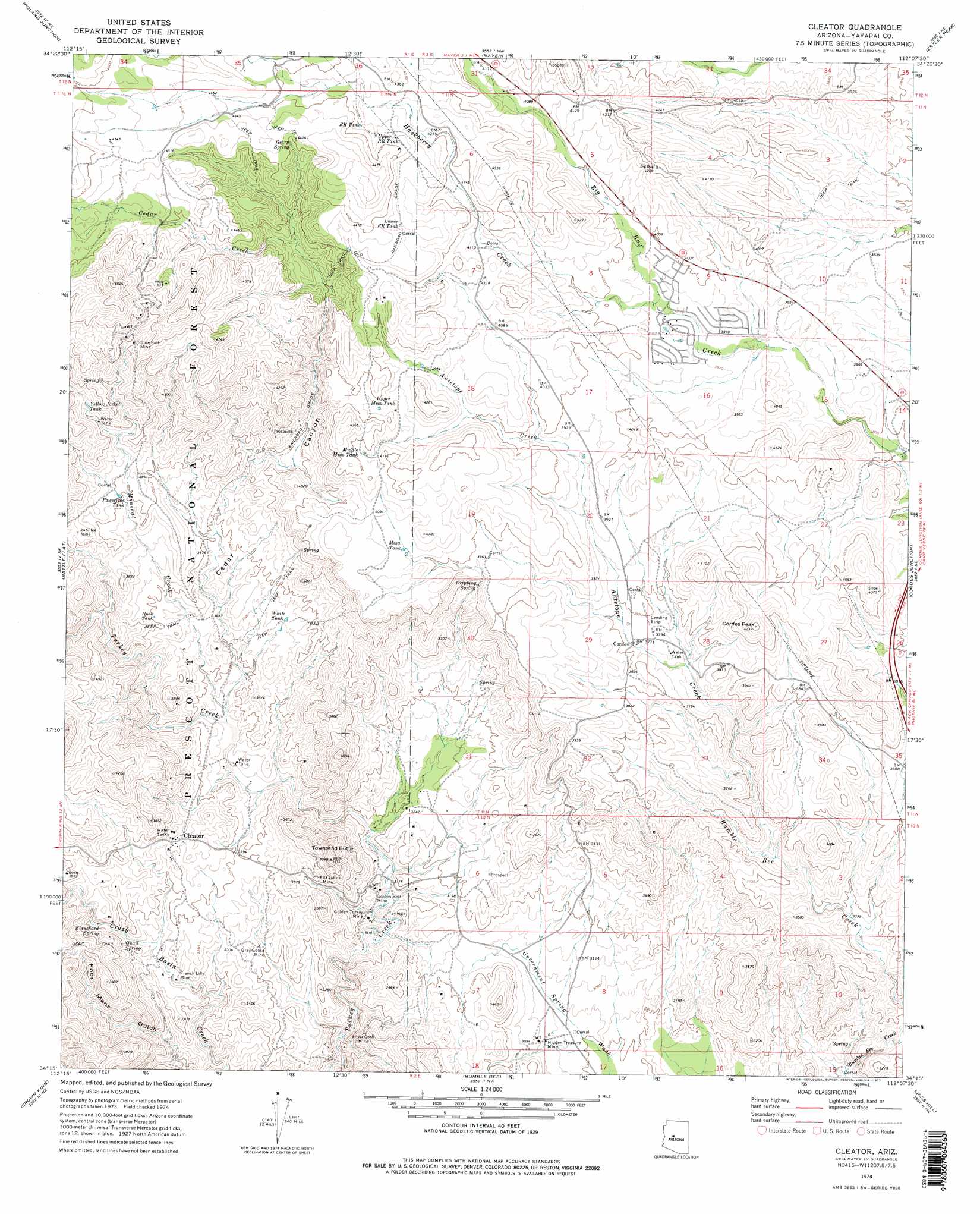
USGS Topo Quad 34112c2 - 1:24,000 scale
| Topo Map Name: | Cleator |
| USGS Topo Quad ID: | 34112c2 |
| Print Size: | ca. 21 1/4" wide x 27" high |
| Southeast Coordinates: | 34.25° N latitude / 112.125° W longitude |
| Map Center Coordinates: | 34.3125° N latitude / 112.1875° W longitude |
| U.S. State: | AZ |
| Filename: | o34112c2.jpg |
| Download Map JPG Image: | Cleator topo map 1:24,000 scale |
| Map Type: | Topographic |
| Topo Series: | 7.5´ |
| Map Scale: | 1:24,000 |
| Source of Map Images: | United States Geological Survey (USGS) |
| Alternate Map Versions: |
Cleator AZ 1974, updated 1977 Download PDF Buy paper map Cleator AZ 1974, updated 1977 Download PDF Buy paper map Cleator AZ 2012 Download PDF Buy paper map Cleator AZ 2014 Download PDF Buy paper map |
| FStopo: | US Forest Service topo Cleator is available: Download FStopo PDF Download FStopo TIF |
1:24,000 Topo Quads surrounding Cleator
Prescott |
Prescott Valley South |
Humboldt |
Cherry |
Middle Verde |
Groom Creek |
Poland Junction |
Mayer |
Estler Peak |
Arnold Mesa |
Battleship Butte |
Battle Flat |
Cleator |
Cordes Junction |
Dugas |
Minnehaha |
Crown King |
Bumble Bee |
Joes Hill |
Brooklyn Peak |
Copperopolis |
Columbia |
Black Canyon City |
Squaw Creek Mesa |
Cooks Mesa |
> Back to 34112a1 at 1:100,000 scale
> Back to 34112a1 at 1:250,000 scale
> Back to U.S. Topo Maps home
Cleator topo map: Gazetteer
Cleator: Airports
Cordes Airport elevation 1155m 3789′Cleator: Mines
Blue Bell Mine elevation 1340m 4396′French Lilly Mine elevation 990m 3248′
Golden Belt Mine elevation 967m 3172′
Golden Turkey Mine elevation 944m 3097′
Gray Goose Mine elevation 988m 3241′
Hidden Treasure Mine elevation 932m 3057′
Jubilee Mine elevation 1175m 3854′
Saint Johns Mine elevation 1054m 3458′
Silver Cord Mine elevation 977m 3205′
Cleator: Populated Places
Cleator elevation 1067m 3500′Cordes elevation 1147m 3763′
Ocotillo elevation 1342m 4402′
Spring Valley elevation 1202m 3943′
Cleator: Reservoirs
Blue Bell Tank Number Two elevation 1371m 4498′Blue Bell Trick Tank elevation 1355m 4445′
Hook Tank elevation 1096m 3595′
Little Cedar Tank elevation 1382m 4534′
Lower RR Tank elevation 1317m 4320′
Mesa Tank elevation 1235m 4051′
Middle Mesa Tank elevation 1269m 4163′
Powerline Tank elevation 1161m 3809′
RR Tank elevation 1322m 4337′
Upper Mesa Tank elevation 1266m 4153′
Upper RR Tank elevation 1318m 4324′
White Tank elevation 1076m 3530′
Yellow Jacket Tank elevation 1232m 4041′
Cleator: Springs
Blanchard Spring elevation 1028m 3372′Dripping Spring elevation 1162m 3812′
Geary Spring elevation 1337m 4386′
Jubilee Spring elevation 1102m 3615′
Quail Spring elevation 1039m 3408′
Cleator: Streams
Antelope Creek elevation 1058m 3471′Cedar Creek elevation 1027m 3369′
Hackberry Creek elevation 1198m 3930′
Mineral Creek elevation 1008m 3307′
Cleator: Summits
Cordes Peak elevation 1286m 4219′Townsend Butte elevation 1198m 3930′
Cleator: Valleys
Cedar Canyon elevation 1014m 3326′Poor Mans Gulch elevation 910m 2985′
Cleator: Wells
Blue Bell Well elevation 1132m 3713′Cedar Well elevation 1336m 4383′
Swiettendick Place Well elevation 1386m 4547′
Cleator digital topo map on disk
Buy this Cleator topo map showing relief, roads, GPS coordinates and other geographical features, as a high-resolution digital map file on DVD: