Bighorn Basin Topo Map California
To zoom in, hover over the map of Bighorn Basin
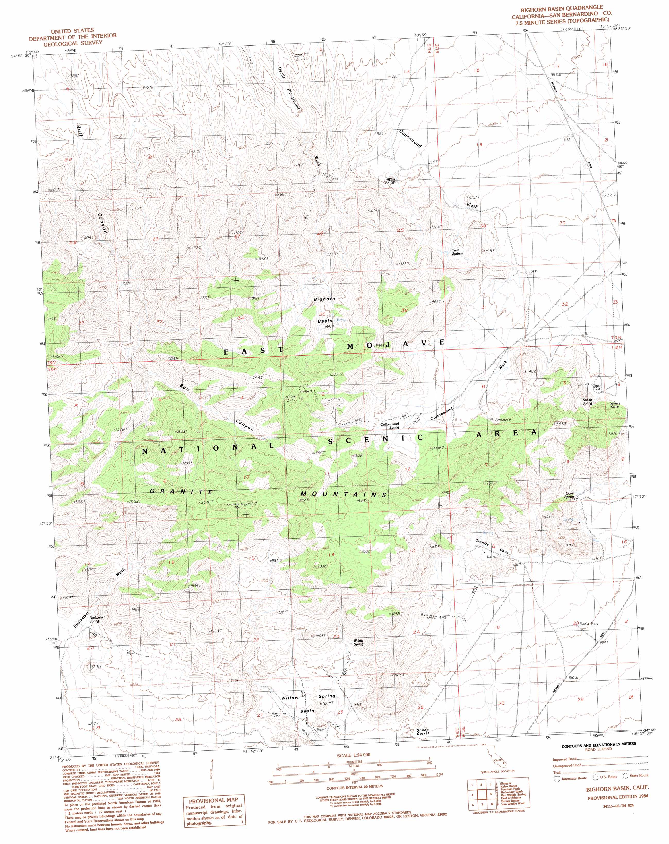
USGS Topo Quad 34115g6 - 1:24,000 scale
| Topo Map Name: | Bighorn Basin |
| USGS Topo Quad ID: | 34115g6 |
| Print Size: | ca. 21 1/4" wide x 27" high |
| Southeast Coordinates: | 34.75° N latitude / 115.625° W longitude |
| Map Center Coordinates: | 34.8125° N latitude / 115.6875° W longitude |
| U.S. State: | CA |
| Filename: | o34115g6.jpg |
| Download Map JPG Image: | Bighorn Basin topo map 1:24,000 scale |
| Map Type: | Topographic |
| Topo Series: | 7.5´ |
| Map Scale: | 1:24,000 |
| Source of Map Images: | United States Geological Survey (USGS) |
| Alternate Map Versions: |
Bighorn Basin CA 1984, updated 1985 Download PDF Buy paper map Bighorn Basin CA 2012 Download PDF Buy paper map Bighorn Basin CA 2015 Download PDF Buy paper map |
1:24,000 Topo Quads surrounding Bighorn Basin
Cowhole Mountain |
Old Dad Mountain |
Kelso |
Hayden |
Columbia Mountain |
West Of Glasgow |
Glasgow |
Kelso Dunes |
Fountain Peak |
Colton Well |
West Of Budweiser Wash |
Budweiser Wash |
Bighorn Basin |
Van Winkle Spring |
West Of Blind Hills |
Siberia |
East Of Siberia |
Brown Buttes |
Van Winkle Wash |
Castle Dome |
Bagdad Sw |
Amboy Crater |
Amboy |
Cadiz |
Cadiz Summit |
> Back to 34115e1 at 1:100,000 scale
> Back to 34114a1 at 1:250,000 scale
> Back to U.S. Topo Maps home
Bighorn Basin topo map: Gazetteer
Bighorn Basin: Basins
Bighorn Basin elevation 1401m 4596′Willow Spring Basin elevation 1171m 3841′
Bighorn Basin: Ranges
Granite Mountains elevation 2007m 6584′Bighorn Basin: Springs
Budweiser Spring elevation 1157m 3795′Cottonwood Spring elevation 1344m 4409′
Cove Spring elevation 1245m 4084′
Coyote Springs elevation 1004m 3293′
Snake Spring elevation 1228m 4028′
Twin Springs elevation 1137m 3730′
Willow Spring elevation 1244m 4081′
Bighorn Basin: Summits
Granite Peak elevation 2057m 6748′Granite Peak Plateau elevation 1801m 5908′
Silver Peak elevation 1935m 6348′
White Fang elevation 1390m 4560′
Bighorn Basin: Valleys
Bull Canyon elevation 796m 2611′Granite Cove elevation 1286m 4219′
Bighorn Basin digital topo map on disk
Buy this Bighorn Basin topo map showing relief, roads, GPS coordinates and other geographical features, as a high-resolution digital map file on DVD: