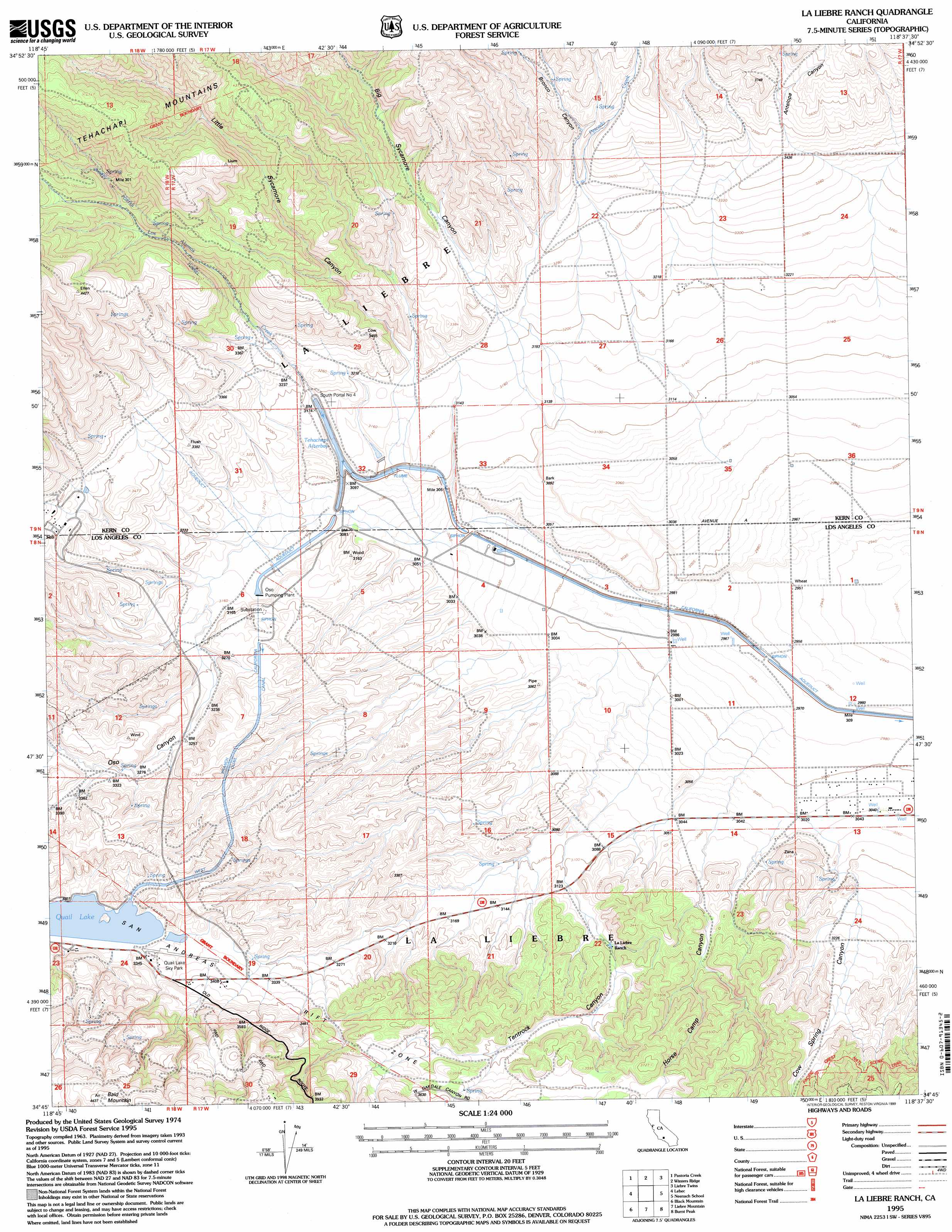
La Liebre Ranch Topo Map California
To zoom in, hover over the map of La Liebre Ranch
USGS Topo Quad 34118g6 - 1:24,000 scale
| Topo Map Name: | La Liebre Ranch |
| USGS Topo Quad ID: | 34118g6 |
| Print Size: | ca. 21 1/4" wide x 27" high |
| Southeast Coordinates: | 34.75° N latitude / 118.625° W longitude |
| Map Center Coordinates: | 34.8125° N latitude / 118.6875° W longitude |
| U.S. State: | CA |
| Filename: | o34118g6.jpg |
| Download Map JPG Image: | La Liebre Ranch topo map 1:24,000 scale |
| Map Type: | Topographic |
| Topo Series: | 7.5´ |
| Map Scale: | 1:24,000 |
| Source of Map Images: | United States Geological Survey (USGS) |
| Alternate Map Versions: |
La Liebre Ranch CA 1965, updated 1967 Download PDF Buy paper map La Liebre Ranch CA 1965, updated 1975 Download PDF Buy paper map La Liebre Ranch CA 1995, updated 1999 Download PDF Buy paper map La Liebre Ranch CA 2012 Download PDF Buy paper map La Liebre Ranch CA 2015 Download PDF Buy paper map |
| FStopo: | US Forest Service topo La Liebre Ranch is available: Download FStopo PDF Download FStopo TIF |
1:24,000 Topo Quads surrounding La Liebre Ranch
Mettler |
Tejon Hills |
Tejon Ranch |
Cummings Mountain |
Tehachapi South |
Grapevine |
Pastoria Creek |
Winters Ridge |
Liebre Twins |
Tylerhorse Canyon |
Frazier Mountain |
Lebec |
La Liebre Ranch |
Neenach School |
Fairmont Butte |
Alamo Mountain |
Black Mountain |
Liebre Mountain |
Burnt Peak |
Lake Hughes |
Devils Heart Peak |
Cobblestone Mountain |
Whitaker Peak |
Warm Springs Mountain |
Green Valley |
> Back to 34118e1 at 1:100,000 scale
> Back to 34118a1 at 1:250,000 scale
> Back to U.S. Topo Maps home
La Liebre Ranch topo map: Gazetteer
La Liebre Ranch: Airports
Quail Lake Sky Park elevation 1019m 3343′La Liebre Ranch: Bays
Tehachapi Afterbay elevation 954m 3129′La Liebre Ranch: Streams
Los Alamos Creek elevation 958m 3143′Pescado Creek elevation 1028m 3372′
La Liebre Ranch: Tunnels
Carley V Porter Tunnel elevation 1183m 3881′South Portal Number Four elevation 965m 3166′
La Liebre Ranch: Valleys
Antelope Canyon elevation 1000m 3280′Big Sycamore Canyon elevation 987m 3238′
Bronco Canyon elevation 1057m 3467′
Cottonwood Canyon elevation 963m 3159′
Cow Spring Canyon elevation 1017m 3336′
Horse Camp Canyon elevation 938m 3077′
Little Sycamore Canyon elevation 968m 3175′
Oso Canyon elevation 973m 3192′
Tentrock Canyon elevation 946m 3103′
La Liebre Ranch digital topo map on disk
Buy this La Liebre Ranch topo map showing relief, roads, GPS coordinates and other geographical features, as a high-resolution digital map file on DVD: