Tarboro Topo Map North Carolina
To zoom in, hover over the map of Tarboro
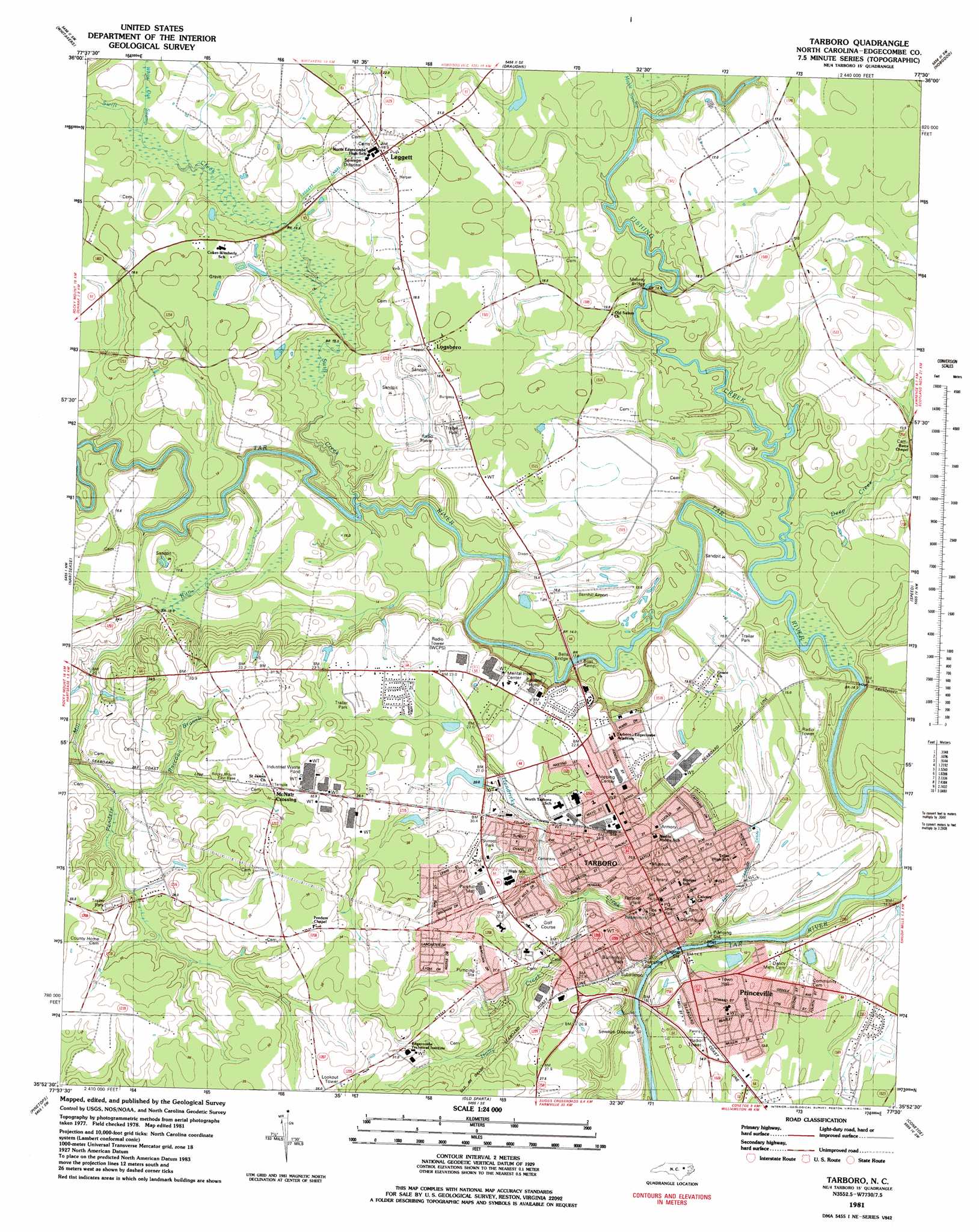
USGS Topo Quad 35077h5 - 1:24,000 scale
| Topo Map Name: | Tarboro |
| USGS Topo Quad ID: | 35077h5 |
| Print Size: | ca. 21 1/4" wide x 27" high |
| Southeast Coordinates: | 35.875° N latitude / 77.5° W longitude |
| Map Center Coordinates: | 35.9375° N latitude / 77.5625° W longitude |
| U.S. State: | NC |
| Filename: | o35077h5.jpg |
| Download Map JPG Image: | Tarboro topo map 1:24,000 scale |
| Map Type: | Topographic |
| Topo Series: | 7.5´ |
| Map Scale: | 1:24,000 |
| Source of Map Images: | United States Geological Survey (USGS) |
| Alternate Map Versions: |
Tarboro NC 1981, updated 1982 Download PDF Buy paper map Tarboro NC 1981, updated 1982 Download PDF Buy paper map Tarboro NC 2010 Download PDF Buy paper map Tarboro NC 2013 Download PDF Buy paper map Tarboro NC 2016 Download PDF Buy paper map |
1:24,000 Topo Quads surrounding Tarboro
Ringwood |
Enfield |
Dawson Crossroads |
Scotland Neck |
Norfleet |
Drake |
Whitakers |
Draughn |
Hobgood |
Palmyra |
Rocky Mount |
Hartsease |
Tarboro |
Speed |
Oak City |
Elm City |
Pinetops |
Old Sparta |
Conetoe |
Robersonville West |
Saratoga |
Fountain |
Falkland |
Greenville Nw |
Greenville Ne |
> Back to 35077e1 at 1:100,000 scale
> Back to 35076a1 at 1:250,000 scale
> Back to U.S. Topo Maps home
Tarboro topo map: Gazetteer
Tarboro: Airports
Barnhill Airport elevation 15m 49′Tarboro: Bridges
Bells Bridge elevation 14m 45′Mabrey Bridge elevation 13m 42′
Tarboro: Canals
East Tarboro Canal elevation 11m 36′Leggett Canal elevation 16m 52′
Tarboro: Dams
Weeks Pond Dam elevation 26m 85′Tarboro: Islands
Hemmed Island elevation 13m 42′Tarboro: Parks
Burlington Park elevation 16m 52′Sunrise Park elevation 23m 75′
Tarboro: Populated Places
Austin Pines elevation 22m 72′Belvedere elevation 22m 72′
Brentwood elevation 23m 75′
Clifton Ridge elevation 30m 98′
Colonial Woods elevation 25m 82′
Cromwell Heights elevation 21m 68′
Deans Heights elevation 16m 52′
Edgecombe Hills elevation 21m 68′
Fairview elevation 22m 72′
Farrar elevation 20m 65′
Forest Acres elevation 16m 52′
Glenburnie elevation 20m 65′
Hilma Park elevation 16m 52′
Hope Lodge elevation 18m 59′
Leggett elevation 18m 59′
Logsboro elevation 18m 59′
Lyndale Acres elevation 22m 72′
McNair Crossing elevation 30m 98′
Mobile Home Estates elevation 24m 78′
Panola Heights elevation 14m 45′
Pine Ridge elevation 22m 72′
Princeville elevation 8m 26′
Runnymeade elevation 20m 65′
Southern Terrace elevation 14m 45′
Speight Forest elevation 28m 91′
Stafford Forest elevation 20m 65′
Summerfield elevation 25m 82′
Sunset Estates elevation 27m 88′
Tarboro elevation 13m 42′
West Hills elevation 21m 68′
West Tarboro elevation 21m 68′
West Tarboro elevation 22m 72′
Woodgreen elevation 30m 98′
Tarboro: Post Offices
Tarboro Post Office elevation 16m 52′Tarboro: Reservoirs
Weeks Pond elevation 26m 85′Tarboro: Streams
Deep Creek elevation 8m 26′Fishing Creek elevation 9m 29′
Harts Mill Run elevation 15m 49′
Hendricks Creek elevation 15m 49′
Holly Creek elevation 10m 32′
Maple Swamp elevation 13m 42′
Penders Mill Run elevation 9m 29′
Raccoon Branch elevation 26m 85′
Swift Creek elevation 13m 42′
White Oak Swamp elevation 15m 49′
Tarboro: Swamps
Hatcher Swamp elevation 26m 85′Tarboro digital topo map on disk
Buy this Tarboro topo map showing relief, roads, GPS coordinates and other geographical features, as a high-resolution digital map file on DVD:
Atlantic Coast (NY, NJ, PA, DE, MD, VA, NC)
Buy digital topo maps: Atlantic Coast (NY, NJ, PA, DE, MD, VA, NC)
 map DVD")