Linville Falls Topo Map North Carolina
To zoom in, hover over the map of Linville Falls
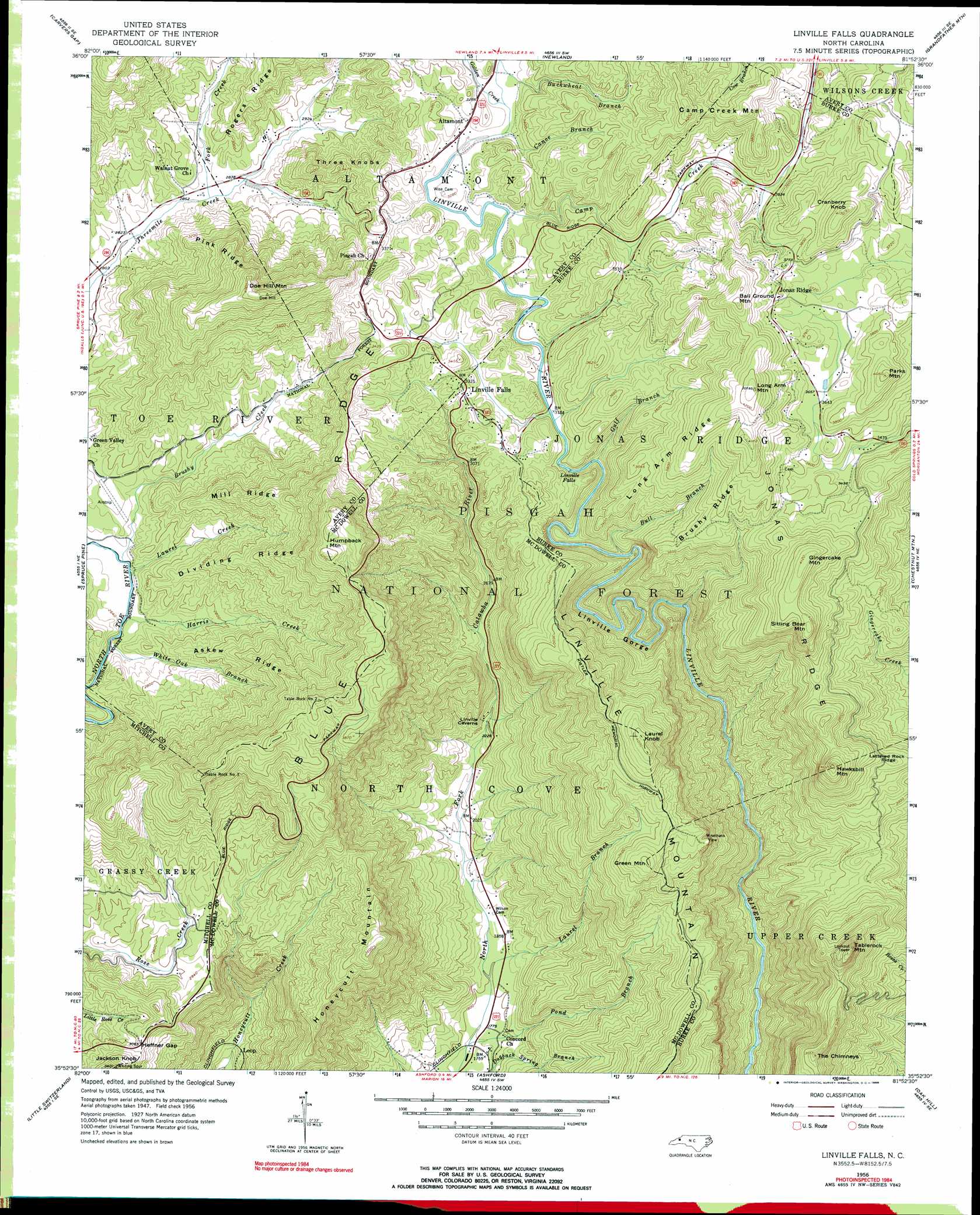
USGS Topo Quad 35081h8 - 1:24,000 scale
| Topo Map Name: | Linville Falls |
| USGS Topo Quad ID: | 35081h8 |
| Print Size: | ca. 21 1/4" wide x 27" high |
| Southeast Coordinates: | 35.875° N latitude / 81.875° W longitude |
| Map Center Coordinates: | 35.9375° N latitude / 81.9375° W longitude |
| U.S. State: | NC |
| Filename: | o35081h8.jpg |
| Download Map JPG Image: | Linville Falls topo map 1:24,000 scale |
| Map Type: | Topographic |
| Topo Series: | 7.5´ |
| Map Scale: | 1:24,000 |
| Source of Map Images: | United States Geological Survey (USGS) |
| Alternate Map Versions: |
Linville Falls NC 1934 Download PDF Buy paper map Linville Falls NC 1956, updated 1958 Download PDF Buy paper map Linville Falls NC 1956, updated 1965 Download PDF Buy paper map Linville Falls NC 1956, updated 1968 Download PDF Buy paper map Linville Falls NC 1956, updated 1984 Download PDF Buy paper map Linville Falls NC 1994, updated 1996 Download PDF Buy paper map Linville Falls NC 1994, updated 1998 Download PDF Buy paper map Linville Falls NC 2011 Download PDF Buy paper map Linville Falls NC 2013 Download PDF Buy paper map Linville Falls NC 2016 Download PDF Buy paper map |
| FStopo: | US Forest Service topo Linville Falls is available: Download FStopo PDF Download FStopo TIF |
1:24,000 Topo Quads surrounding Linville Falls
Iron Mountain Gap |
White Rocks Mountain |
Elk Park |
Valle Crucis |
Boone |
Bakersville |
Carvers Gap |
Newland |
Grandfather Mountain |
Globe |
Micaville |
Spruce Pine |
Linville Falls |
Chestnut Mountain |
Collettsville |
Celo |
Little Switzerland |
Ashford |
Oak Hill |
Morganton North |
Old Fort |
Marion West |
Marion East |
Glen Alpine |
Morganton South |
> Back to 35081e1 at 1:100,000 scale
> Back to 35080a1 at 1:250,000 scale
> Back to U.S. Topo Maps home
Linville Falls topo map: Gazetteer
Linville Falls: Airports
Avery County Airport elevation 828m 2716′Linville Falls: Falls
Linville Falls elevation 960m 3149′Linville Falls: Gaps
Heffner Gap elevation 930m 3051′Linville Falls: Populated Places
Altamont elevation 996m 3267′Jonas Ridge elevation 1161m 3809′
Linville Falls elevation 1021m 3349′
Three Mile elevation 881m 2890′
Wisemans View elevation 1048m 3438′
Linville Falls: Ridges
Askew Ridge elevation 983m 3225′Brushy Ridge elevation 1138m 3733′
Dividing Ridge elevation 988m 3241′
Jonas Ridge elevation 1245m 4084′
Linville Mountain elevation 977m 3205′
Long Arm Ridge elevation 1145m 3756′
Mill Ridge elevation 985m 3231′
Pink Ridge elevation 1073m 3520′
Linville Falls: Streams
Brushy Creek elevation 797m 2614′Bull Branch elevation 894m 2933′
Camp Creek elevation 983m 3225′
Canoe Branch elevation 991m 3251′
Fork Creek elevation 868m 2847′
Gulf Branch elevation 928m 3044′
Harris Creek elevation 798m 2618′
Laurel Branch elevation 548m 1797′
Laurel Creek elevation 796m 2611′
Pond Branch elevation 532m 1745′
Stamey Branch elevation 992m 3254′
White Oak Creek elevation 793m 2601′
Linville Falls: Summits
Ball Ground Mountain elevation 1292m 4238′Camp Creek Mountain elevation 1257m 4124′
Cranberry Knob elevation 1259m 4130′
Doe Hill Mountain elevation 1230m 4035′
Gingercake Mountain elevation 1263m 4143′
Green Mountain elevation 1107m 3631′
Hawksbill Mountain elevation 1218m 3996′
Honeycutt Mountain elevation 1100m 3608′
Humpback Mountain elevation 1294m 4245′
Jackson Knob elevation 1037m 3402′
Laurel Knob elevation 1237m 4058′
Long Arm Mountain elevation 1287m 4222′
Parks Mountain elevation 1236m 4055′
Sitting Bear Mountain elevation 1242m 4074′
Table Rock Mountain elevation 1198m 3930′
The Chimneys elevation 1059m 3474′
Three Knobs elevation 1048m 3438′
Linville Falls: Valleys
Linville Gorge elevation 735m 2411′Linville Falls digital topo map on disk
Buy this Linville Falls topo map showing relief, roads, GPS coordinates and other geographical features, as a high-resolution digital map file on DVD:
South Carolina, Western North Carolina & Northeastern Georgia
Buy digital topo maps: South Carolina, Western North Carolina & Northeastern Georgia