Little Switzerland Topo Map North Carolina
To zoom in, hover over the map of Little Switzerland
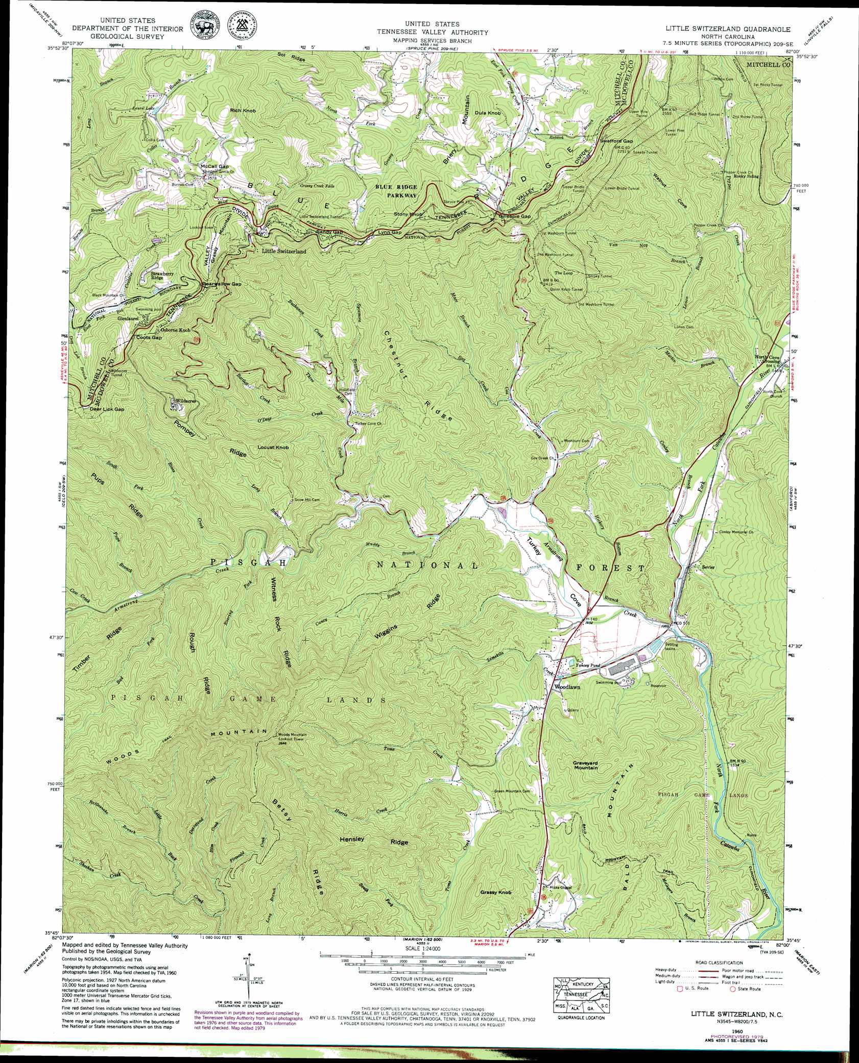
USGS Topo Quad 35082g1 - 1:24,000 scale
| Topo Map Name: | Little Switzerland |
| USGS Topo Quad ID: | 35082g1 |
| Print Size: | ca. 21 1/4" wide x 27" high |
| Southeast Coordinates: | 35.75° N latitude / 82° W longitude |
| Map Center Coordinates: | 35.8125° N latitude / 82.0625° W longitude |
| U.S. State: | NC |
| Filename: | o35082g1.jpg |
| Download Map JPG Image: | Little Switzerland topo map 1:24,000 scale |
| Map Type: | Topographic |
| Topo Series: | 7.5´ |
| Map Scale: | 1:24,000 |
| Source of Map Images: | United States Geological Survey (USGS) |
| Alternate Map Versions: |
Little Switzerland NC 1960, updated 1962 Download PDF Buy paper map Little Switzerland NC 1960, updated 1974 Download PDF Buy paper map Little Switzerland NC 1960, updated 1979 Download PDF Buy paper map Little Switzerland NC 1960, updated 1988 Download PDF Buy paper map Little Switzerland NC 1960, updated 1988 Download PDF Buy paper map Little Switzerland NC 1994, updated 1998 Download PDF Buy paper map Little Switzerland NC 2011 Download PDF Buy paper map Little Switzerland NC 2013 Download PDF Buy paper map Little Switzerland NC 2016 Download PDF Buy paper map |
| FStopo: | US Forest Service topo Little Switzerland is available: Download FStopo PDF Download FStopo TIF |
1:24,000 Topo Quads surrounding Little Switzerland
Huntdale |
Bakersville |
Carvers Gap |
Newland |
Grandfather Mountain |
Burnsville |
Micaville |
Spruce Pine |
Linville Falls |
Chestnut Mountain |
Mount Mitchell |
Celo |
Little Switzerland |
Ashford |
Oak Hill |
Montreat |
Old Fort |
Marion West |
Marion East |
Glen Alpine |
Black Mountain |
Moffitt Hill |
Sugar Hill |
Glenwood |
Dysartsville |
> Back to 35082e1 at 1:100,000 scale
> Back to 35082a1 at 1:250,000 scale
> Back to U.S. Topo Maps home
Little Switzerland topo map: Gazetteer
Little Switzerland: Dams
Buckner Dam elevation 1001m 3284′Little Switzerland: Falls
Grassy Creek Falls elevation 949m 3113′Little Switzerland: Gaps
Bearwallow Gap elevation 1059m 3474′Deer Lick Gap elevation 1053m 3454′
Gillespie Gap elevation 855m 2805′
Gooch Gap elevation 1025m 3362′
Lynn Gap elevation 946m 3103′
McCall Gap elevation 1087m 3566′
Sandy Gap elevation 1017m 3336′
Sandy Gap elevation 1005m 3297′
Swafford Gap elevation 865m 2837′
Little Switzerland: Populated Places
Glenlaurel elevation 1030m 3379′Little Switzerland elevation 1057m 3467′
North Cove Crossing elevation 447m 1466′
Osborne Knob elevation 1076m 3530′
Sevier elevation 427m 1400′
Strawberry Ridge elevation 1060m 3477′
Wildacres elevation 967m 3172′
Woodlawn elevation 438m 1437′
Little Switzerland: Reservoirs
Buckner Lake elevation 1001m 3284′Laurel Lake elevation 1083m 3553′
Yancey Pond elevation 432m 1417′
Little Switzerland: Ridges
Betsy Creek elevation 903m 2962′Chestnut Ridge elevation 695m 2280′
Hensley Ridge elevation 701m 2299′
Pompey Ridge elevation 819m 2687′
Pups Ridge elevation 873m 2864′
Rough Ridge elevation 764m 2506′
Sol Ridge elevation 1051m 3448′
Wiggins Ridge elevation 646m 2119′
Witness Rock Ridge elevation 801m 2627′
Little Switzerland: Streams
Armstrong Creek elevation 415m 1361′Bad Fork elevation 544m 1784′
Bartlett Creek elevation 590m 1935′
Buchanan Creek elevation 551m 1807′
Caney Branch elevation 450m 1476′
Collis Branch elevation 926m 3038′
Conley Branch elevation 424m 1391′
Cow Creek elevation 578m 1896′
Cox Creek elevation 430m 1410′
Deer Lick Branch elevation 941m 3087′
Deerstand Creek elevation 515m 1689′
Firescald Creek elevation 596m 1955′
Harris Creek elevation 490m 1607′
Hickory Bottom Branch elevation 421m 1381′
Limekiln Creek elevation 417m 1368′
Long Branch elevation 498m 1633′
Lonon Branch elevation 467m 1532′
Mace Branch elevation 511m 1676′
Martin Branch elevation 434m 1423′
Muddy Branch elevation 469m 1538′
North Fork Grassy Creek elevation 824m 2703′
ODear Creek elevation 520m 1706′
Pepper Creek elevation 437m 1433′
Pups Branch elevation 552m 1811′
Rag Creek elevation 465m 1525′
Rattlesnake Branch elevation 599m 1965′
Reddick Branch elevation 820m 2690′
Roaring Fork elevation 503m 1650′
Roses Creek elevation 526m 1725′
Sheehan Creek elevation 560m 1837′
Slim Creek elevation 582m 1909′
South Fork Roses Creek elevation 604m 1981′
Sycamore Branch elevation 536m 1758′
Three Mile Creek elevation 465m 1525′
Van Noy Branch elevation 490m 1607′
Little Switzerland: Summits
Briery Mountain elevation 890m 2919′Dula Knob elevation 934m 3064′
Grassy Knob elevation 613m 2011′
Grassy Mountain elevation 1174m 3851′
Graveyard Mountain elevation 688m 2257′
Locust Knob elevation 802m 2631′
Osborne Knob elevation 1085m 3559′
Rich Knob elevation 1203m 3946′
Silver Knob elevation 930m 3051′
Stony Knob elevation 1008m 3307′
Woods Mountain elevation 1108m 3635′
Little Switzerland: Trails
Bald Mountain Trail elevation 598m 1961′Little Switzerland: Tunnels
Bird Ridge Tunnel elevation 714m 2342′First Rocky Tunnel elevation 687m 2253′
First Washburn Tunnel elevation 803m 2634′
Little Switzerland Tunnel elevation 1063m 3487′
Lower Bridle Tunnel elevation 825m 2706′
Lower Pine Tunnel elevation 822m 2696′
Quinn Knob Tunnel elevation 759m 2490′
Second Rocky Tunnel elevation 684m 2244′
Second Washburn Tunnel elevation 760m 2493′
Snipes Tunnel elevation 770m 2526′
Speedy Tunnel elevation 724m 2375′
Third Washburn Tunnel elevation 790m 2591′
Upper Bridle Tunnel elevation 816m 2677′
Upper Pine Tunnel elevation 863m 2831′
Wildacres Tunnel elevation 1080m 3543′
Little Switzerland: Valleys
Turkey Cove elevation 420m 1377′Walnut Cove elevation 478m 1568′
Little Switzerland digital topo map on disk
Buy this Little Switzerland topo map showing relief, roads, GPS coordinates and other geographical features, as a high-resolution digital map file on DVD:
South Carolina, Western North Carolina & Northeastern Georgia
Buy digital topo maps: South Carolina, Western North Carolina & Northeastern Georgia