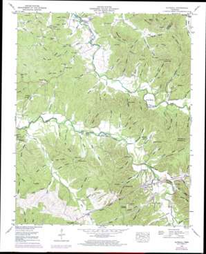
Olivehill Topo Map Tennessee
To zoom in, hover over the map of Olivehill
USGS Topo Quad 35088c1 - 1:24,000 scale
| Topo Map Name: | Olivehill |
| USGS Topo Quad ID: | 35088c1 |
| Print Size: | ca. 21 1/4" wide x 27" high |
| Southeast Coordinates: | 35.25° N latitude / 88° W longitude |
| Map Center Coordinates: | 35.3125° N latitude / 88.0625° W longitude |
| U.S. State: | TN |
| Filename: | o35088c1.jpg |
| Download Map JPG Image: | Olivehill topo map 1:24,000 scale |
| Map Type: | Topographic |
| Topo Series: | 7.5´ |
| Map Scale: | 1:24,000 |
| Source of Map Images: | United States Geological Survey (USGS) |
| Alternate Map Versions: |
Olivehill TN 1936 Download PDF Buy paper map Olivehill TN 1949, updated 1952 Download PDF Buy paper map Olivehill TN 1949, updated 1973 Download PDF Buy paper map Olivehill TN 1949, updated 1973 Download PDF Buy paper map Olivehill TN 2010 Download PDF Buy paper map Olivehill TN 2013 Download PDF Buy paper map Olivehill TN 2016 Download PDF Buy paper map |
1:24,000 Topo Quads surrounding Olivehill
> Back to 35088a1 at 1:100,000 scale
> Back to 35088a1 at 1:250,000 scale
> Back to U.S. Topo Maps home
Olivehill topo map: Gazetteer
Olivehill: Basins
Hannah Sink elevation 153m 501′Olivehill: Bridges
Arch Bridge elevation 140m 459′Olivehill: Cliffs
Dickson Bluff elevation 163m 534′Olivehill: Crossings
Bryant Ford elevation 139m 456′Clark Ford elevation 117m 383′
Garrard Ford elevation 128m 419′
Hardin Ford elevation 127m 416′
Hudiburg Ford elevation 139m 456′
Johnson Ford elevation 114m 374′
Linville Ford elevation 140m 459′
Porter Ford elevation 122m 400′
Sims Ford elevation 120m 393′
Whitten Ford elevation 134m 439′
Olivehill: Gaps
Flat Gap elevation 146m 479′Olivehill: Islands
Bailey Island elevation 134m 439′Davis Island elevation 122m 400′
Sandy Bottom Island elevation 128m 419′
Olivehill: Lakes
Duncan Pond (historical) elevation 156m 511′Olivehill: Populated Places
Bethlehem elevation 153m 501′Crossroads elevation 168m 551′
Crowtexas elevation 195m 639′
Havana elevation 173m 567′
Olivehill elevation 165m 541′
Piney Grove elevation 149m 488′
Smiths Fork (historical) elevation 146m 479′
Thompson Crossroads elevation 219m 718′
Olivehill: Ridges
Backbone Ridge elevation 178m 583′Blackshire Ridge elevation 201m 659′
Forge Ridge elevation 184m 603′
Gravel Pit elevation 207m 679′
Pine Knob Ridge elevation 196m 643′
Walker Ridge elevation 192m 629′
Olivehill: Springs
Bolden Spring elevation 168m 551′Cave Spring elevation 139m 456′
Copperas Spring elevation 160m 524′
Day Spring elevation 174m 570′
Dowdy Spring elevation 147m 482′
Garrard Cave Spring elevation 134m 439′
Hardin Spring elevation 138m 452′
Hardin Spring elevation 153m 501′
Hudiburg Spring elevation 176m 577′
Reynolds Spring elevation 168m 551′
Sims Spring elevation 154m 505′
Olivehill: Streams
Akins Branch elevation 121m 396′Baugus Branch elevation 133m 436′
Bear Branch elevation 137m 449′
Bear Branch elevation 114m 374′
Berry Branch elevation 113m 370′
Bigbee Branch elevation 135m 442′
Bowling Branch elevation 129m 423′
Brashier Branch elevation 124m 406′
Eagle Creek elevation 128m 419′
Flat Gap Creek elevation 134m 439′
Franklin Branch elevation 134m 439′
Gravett Branch elevation 139m 456′
Hardin Branch elevation 123m 403′
Hardin Branch elevation 135m 442′
Hulin Branch elevation 127m 416′
Lovefield Branch elevation 126m 413′
McCasland Branch elevation 122m 400′
Northcutt Branch elevation 140m 459′
Panther Branch elevation 141m 462′
Pulley Branch elevation 115m 377′
Reynolds Branch elevation 150m 492′
Rocky Branch elevation 115m 377′
Rose Branch elevation 117m 383′
Simmons Branch elevation 131m 429′
Smith Fork elevation 122m 400′
Olivehill: Summits
Russ Coalings elevation 209m 685′Olivehill: Valleys
Ashworth Hollow elevation 132m 433′Banks Hollow elevation 119m 390′
Baxter Hollow elevation 126m 413′
Beckham Hollow elevation 125m 410′
Bee Hollow elevation 146m 479′
Boat Gunwale Hollow elevation 151m 495′
Boneyard Hollow elevation 127m 416′
Bratten Hollow elevation 137m 449′
Burns Hollow elevation 134m 439′
Buzzard Cave Hollow elevation 125m 410′
Caney Hollow elevation 128m 419′
Christian Hollow elevation 123m 403′
Clausel Hollow elevation 151m 495′
Dark Hollow elevation 139m 456′
Davis Hollow elevation 130m 426′
Davis Hollow elevation 132m 433′
Day Hollow elevation 137m 449′
Dowdy Hollow elevation 129m 423′
Duckworth Hollow elevation 131m 429′
Gant Hollow elevation 141m 462′
Gillham Hollow elevation 120m 393′
Gilmore Hollow elevation 136m 446′
Gray Hollow elevation 129m 423′
Hamilton Hollow elevation 125m 410′
Hannah Hollow elevation 138m 452′
Henry Hardin Hollow elevation 130m 426′
Hogpen Hollow elevation 129m 423′
Hosey Hollow elevation 117m 383′
Hughes Hollow elevation 149m 488′
Jeff Hollow elevation 133m 436′
Joe Hollow elevation 145m 475′
Jordan Hollow elevation 150m 492′
King Hollow elevation 131m 429′
Mag Hollow elevation 136m 446′
Marshall Hollow elevation 145m 475′
Mash Hollow elevation 151m 495′
McCollum Hollow elevation 136m 446′
Mill Hollow elevation 138m 452′
Morris Hollow elevation 136m 446′
Norton Hollow elevation 124m 406′
Owl Hollow elevation 144m 472′
Paradise Hollow elevation 137m 449′
Pitts Hollow elevation 120m 393′
Polk Hollow elevation 122m 400′
Pool Hollow elevation 145m 475′
Rose Hollow elevation 123m 403′
Schoolhouse Hollow elevation 119m 390′
Sims Hollow elevation 121m 396′
Spear Hollow elevation 134m 439′
Stricklin Hollow elevation 144m 472′
Tanyard Hollow elevation 147m 482′
Ticey Hollow elevation 119m 390′
Turkey Hollow elevation 134m 439′
Wad Hardin Hollow elevation 122m 400′
Walker Hollow elevation 132m 433′
Yarbrough Hollow elevation 137m 449′
Olivehill digital topo map on disk
Buy this Olivehill topo map showing relief, roads, GPS coordinates and other geographical features, as a high-resolution digital map file on DVD:


