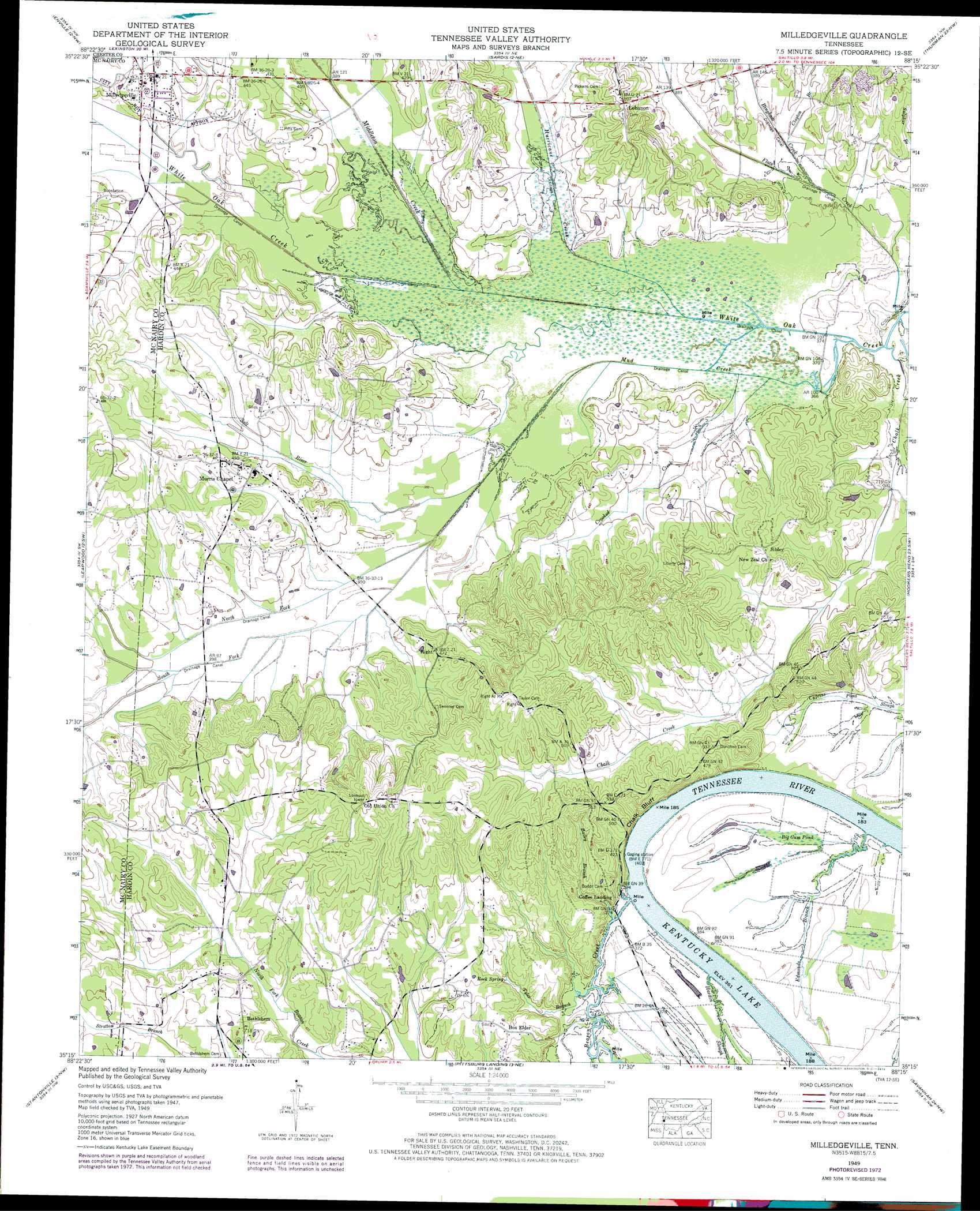
Milledgeville Topo Map Tennessee
To zoom in, hover over the map of Milledgeville
USGS Topo Quad 35088c3 - 1:24,000 scale
| Topo Map Name: | Milledgeville |
| USGS Topo Quad ID: | 35088c3 |
| Print Size: | ca. 21 1/4" wide x 27" high |
| Southeast Coordinates: | 35.25° N latitude / 88.25° W longitude |
| Map Center Coordinates: | 35.3125° N latitude / 88.3125° W longitude |
| U.S. State: | TN |
| Filename: | o35088c3.jpg |
| Download Map JPG Image: | Milledgeville topo map 1:24,000 scale |
| Map Type: | Topographic |
| Topo Series: | 7.5´ |
| Map Scale: | 1:24,000 |
| Source of Map Images: | United States Geological Survey (USGS) |
| Alternate Map Versions: |
Milledgeville TN 1936 Download PDF Buy paper map Milledgeville TN 1949, updated 1952 Download PDF Buy paper map Milledgeville TN 1949, updated 1973 Download PDF Buy paper map Milledgeville TN 2010 Download PDF Buy paper map Milledgeville TN 2013 Download PDF Buy paper map Milledgeville TN 2016 Download PDF Buy paper map |
1:24,000 Topo Quads surrounding Milledgeville
Luray |
Life |
Reagan |
Scotts Hill |
Perryville |
Jacks Creek |
Enville |
Sardis |
Thurman |
Bath Springs |
Mount Peter |
Leapwood |
Milledgeville |
Hookers Bend |
Olivehill |
Purdy |
Stantonville |
Pittsburg Landing |
Savannah |
Wolf Pit Ridge |
Guys |
Michie |
Counce |
Pickwick |
Lowryville |
> Back to 35088a1 at 1:100,000 scale
> Back to 35088a1 at 1:250,000 scale
> Back to U.S. Topo Maps home
Milledgeville topo map: Gazetteer
Milledgeville: Canals
Mud Creek Canal elevation 113m 370′White Oak Creek Canal elevation 113m 370′
Milledgeville: Cliffs
Chalk Bluff elevation 127m 416′Milledgeville: Crossings
Nelsons Ferry (historical) elevation 110m 360′Milledgeville: Populated Places
Bethlehem elevation 136m 446′Box Elder elevation 136m 446′
Lebanon elevation 154m 505′
Milledgeville elevation 128m 419′
Morris Chapel elevation 136m 446′
Sibley elevation 147m 482′
Milledgeville: Springs
Rock Spring elevation 121m 396′Milledgeville: Streams
Bailey Branch elevation 111m 364′Beason Creek elevation 110m 360′
Bingham Creek elevation 113m 370′
Chalk Creek elevation 112m 367′
Clayton Branch elevation 114m 374′
Crooked Creek elevation 112m 367′
Davy Branch elevation 112m 367′
Edmonds Branch elevation 111m 364′
Flats Creek elevation 111m 364′
Hardin Slough elevation 110m 360′
Holley Creek elevation 128m 419′
Hurricane Creek elevation 112m 367′
Middleton Creek elevation 112m 367′
Mud Creek elevation 112m 367′
North Fork Mud Creek elevation 114m 374′
Salt River elevation 114m 374′
Short Branch elevation 115m 377′
South Fork Mud Creek elevation 115m 377′
Tyler Branch elevation 112m 367′
Milledgeville: Swamps
Big Gum Pond elevation 113m 370′Milledgeville digital topo map on disk
Buy this Milledgeville topo map showing relief, roads, GPS coordinates and other geographical features, as a high-resolution digital map file on DVD: