Tuscocoillo Canyon Topo Map New Mexico
To zoom in, hover over the map of Tuscocoillo Canyon
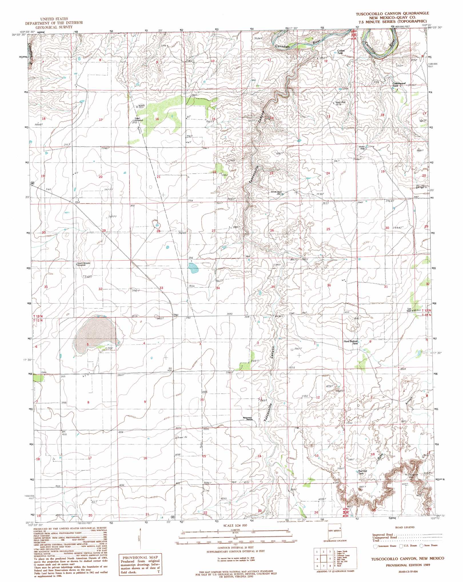
USGS Topo Quad 35103c3 - 1:24,000 scale
| Topo Map Name: | Tuscocoillo Canyon |
| USGS Topo Quad ID: | 35103c3 |
| Print Size: | ca. 21 1/4" wide x 27" high |
| Southeast Coordinates: | 35.25° N latitude / 103.25° W longitude |
| Map Center Coordinates: | 35.3125° N latitude / 103.3125° W longitude |
| U.S. State: | NM |
| Filename: | o35103c3.jpg |
| Download Map JPG Image: | Tuscocoillo Canyon topo map 1:24,000 scale |
| Map Type: | Topographic |
| Topo Series: | 7.5´ |
| Map Scale: | 1:24,000 |
| Source of Map Images: | United States Geological Survey (USGS) |
| Alternate Map Versions: |
Tuscocoillo Canyon NM 1989, updated 1989 Download PDF Buy paper map Tuscocoillo Canyon NM 2010 Download PDF Buy paper map Tuscocoillo Canyon NM 2013 Download PDF Buy paper map Tuscocoillo Canyon NM 2017 Download PDF Buy paper map |
1:24,000 Topo Quads surrounding Tuscocoillo Canyon
Fuentes Ranch |
Mccarty Ranch |
Lockney |
Obar |
Nara Visa |
Montesito Creek |
Logan North |
Logan Ne |
Cammak Camp |
Sanchez Springs |
Hudson |
Logan South |
Tuscocoillo Canyon |
Blue Hole |
Martin Draw |
Lesbia |
San Jon Nw |
Porter |
Bard |
Glenrio |
Tucumcari Se |
Bedford Hill |
San Jon |
Riley Camp |
Rock Camp |
> Back to 35103a1 at 1:100,000 scale
> Back to 35102a1 at 1:250,000 scale
> Back to U.S. Topo Maps home
Tuscocoillo Canyon topo map: Gazetteer
Tuscocoillo Canyon: Populated Places
Anniston (historical) elevation 1154m 3786′Woods Place elevation 1197m 3927′
Tuscocoillo Canyon: Reservoirs
Collins Tank elevation 1130m 3707′Cottonwood Tank elevation 1134m 3720′
Hard Bottom Tank elevation 1206m 3956′
Red Hill Tank elevation 1198m 3930′
Tuscocoillo Canyon: Valleys
Tuscocoillo Canyon elevation 1104m 3622′Tuscocoillo Canyon: Wells
05386 Water Well elevation 1189m 3900′05387 Water Well elevation 1208m 3963′
05388 Water Well elevation 1200m 3937′
05391 Water Well elevation 1216m 3989′
05392 Water Well elevation 1215m 3986′
05393 Water Well elevation 1196m 3923′
05394 Water Well elevation 1222m 4009′
05395 Water Well elevation 1222m 4009′
05396 Water Well elevation 1252m 4107′
05397 Water Well elevation 1259m 4130′
05408 Water Well elevation 1200m 3937′
05409 Water Well elevation 1189m 3900′
05410 Water Well elevation 1184m 3884′
05511 Water Well elevation 1168m 3832′
05512 Water Well elevation 1210m 3969′
05513 Water Well elevation 1185m 3887′
05514 Water Well elevation 1211m 3973′
05515 Water Well elevation 1176m 3858′
05518 Water Well elevation 1134m 3720′
05521 Water Well elevation 1190m 3904′
Tuscocoillo Canyon digital topo map on disk
Buy this Tuscocoillo Canyon topo map showing relief, roads, GPS coordinates and other geographical features, as a high-resolution digital map file on DVD: