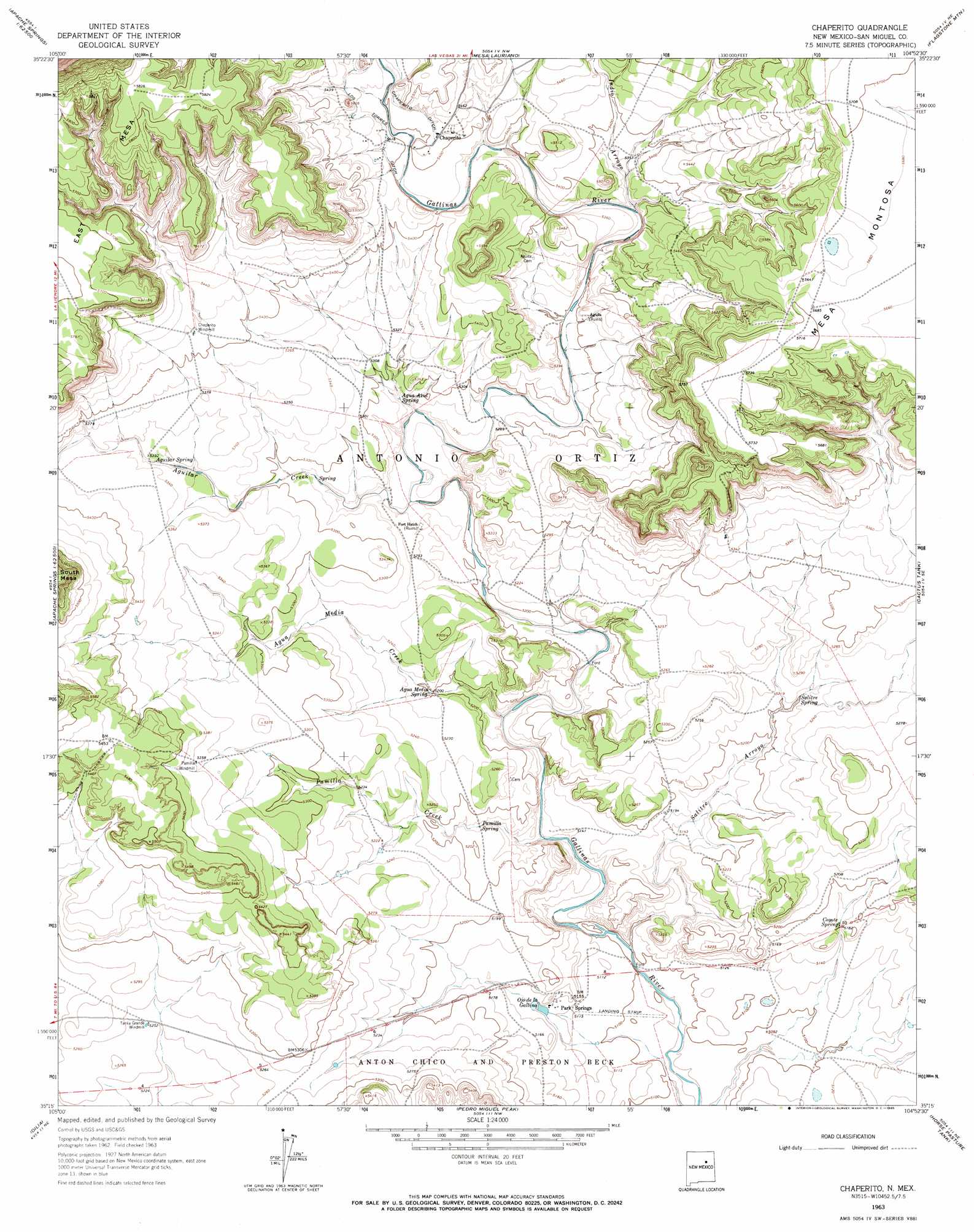
Chaperito Topo Map New Mexico
To zoom in, hover over the map of Chaperito
USGS Topo Quad 35104c8 - 1:24,000 scale
| Topo Map Name: | Chaperito |
| USGS Topo Quad ID: | 35104c8 |
| Print Size: | ca. 21 1/4" wide x 27" high |
| Southeast Coordinates: | 35.25° N latitude / 104.875° W longitude |
| Map Center Coordinates: | 35.3125° N latitude / 104.9375° W longitude |
| U.S. State: | NM |
| Filename: | o35104c8.jpg |
| Download Map JPG Image: | Chaperito topo map 1:24,000 scale |
| Map Type: | Topographic |
| Topo Series: | 7.5´ |
| Map Scale: | 1:24,000 |
| Source of Map Images: | United States Geological Survey (USGS) |
| Alternate Map Versions: |
Chaperito NM 1963, updated 1965 Download PDF Buy paper map Chaperito NM 2010 Download PDF Buy paper map Chaperito NM 2013 Download PDF Buy paper map Chaperito NM 2017 Download PDF Buy paper map |
1:24,000 Topo Quads surrounding Chaperito
Las Vegas |
Las Vegas Se |
Laguna La Monia |
Laguna Huerfana |
Trujillo |
Los Montoyas |
La Liendre |
Mesa Lauriano |
Flagstone Mountain |
Punta Del Chorro |
Apache Springs |
Mesa Chupinas |
Chaperito |
Cactus Tank |
Cabra Hill |
Anton Chico |
Dilia |
Pedro Miguel Peak |
Horse Pasture Tank |
Bar Y Ranch |
Mesa Palo Amarillo |
Thompson Ranch |
Mesita De Guadalupe |
Colonias |
Catfish Falls |
> Back to 35104a1 at 1:100,000 scale
> Back to 35104a1 at 1:250,000 scale
> Back to U.S. Topo Maps home
Chaperito topo map: Gazetteer
Chaperito: Airports
Park Springs Airport elevation 1556m 5104′Chaperito: Canals
Chaperito Ditch elevation 1653m 5423′Chaperito: Mines
Park Springs Ranch Mine elevation 1689m 5541′Pecos Coal Mine elevation 1689m 5541′
Chaperito: Populated Places
Chaperito elevation 1652m 5419′Park Springs elevation 1565m 5134′
Chaperito: Post Offices
Chaperito Post Office (historical) elevation 1652m 5419′Park Springs Post Office (historical) elevation 1565m 5134′
Chaperito: Reservoirs
Tanke Grande elevation 1598m 5242′Chaperito: Springs
Agua Azul Spring elevation 1599m 5246′Agua Medio Spring elevation 1584m 5196′
Aguilar Spring elevation 1628m 5341′
Coyote Spring elevation 1574m 5164′
Ojo de la Gallina elevation 1568m 5144′
Pamilla Spring elevation 1574m 5164′
Park Springs elevation 1568m 5144′
Salitre Spring elevation 1586m 5203′
Chaperito: Streams
Agua Media Creek elevation 1566m 5137′Aguilar Creek elevation 1590m 5216′
Indio Arroyo elevation 1619m 5311′
Pamilla Creek elevation 1560m 5118′
Salitre Arroyo elevation 1604m 5262′
Chaperito: Summits
East Mesa elevation 1780m 5839′Chaperito digital topo map on disk
Buy this Chaperito topo map showing relief, roads, GPS coordinates and other geographical features, as a high-resolution digital map file on DVD: