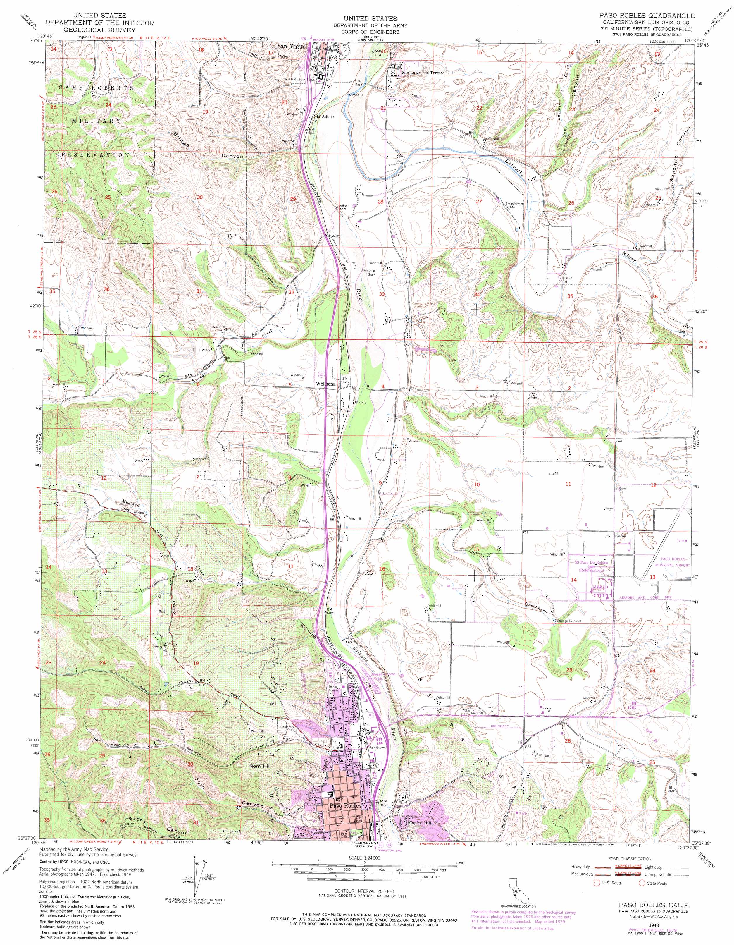
Paso Robles Topo Map California
To zoom in, hover over the map of Paso Robles
USGS Topo Quad 35120f6 - 1:24,000 scale
| Topo Map Name: | Paso Robles |
| USGS Topo Quad ID: | 35120f6 |
| Print Size: | ca. 21 1/4" wide x 27" high |
| Southeast Coordinates: | 35.625° N latitude / 120.625° W longitude |
| Map Center Coordinates: | 35.6875° N latitude / 120.6875° W longitude |
| U.S. State: | CA |
| Filename: | o35120f6.jpg |
| Download Map JPG Image: | Paso Robles topo map 1:24,000 scale |
| Map Type: | Topographic |
| Topo Series: | 7.5´ |
| Map Scale: | 1:24,000 |
| Source of Map Images: | United States Geological Survey (USGS) |
| Alternate Map Versions: |
Paso Robles CA 1948, updated 1952 Download PDF Buy paper map Paso Robles CA 1948, updated 1971 Download PDF Buy paper map Paso Robles CA 1948, updated 1984 Download PDF Buy paper map Paso Robles CA 1948, updated 1984 Download PDF Buy paper map Paso Robles CA 2012 Download PDF Buy paper map Paso Robles CA 2015 Download PDF Buy paper map |
1:24,000 Topo Quads surrounding Paso Robles
Hames Valley |
Wunpost |
Valleton |
Stockdale Mountain |
Parkfield |
Tierra Redondo Mountain |
Bradley |
San Miguel |
Ranchito Canyon |
Cholame Hills |
Lime Mountain |
Adelaida |
Paso Robles |
Estrella |
Shandon |
Cypress Mountain |
York Mountain |
Templeton |
Creston |
Shedd Canyon |
Cayucos |
Morro Bay North |
Atascadero |
Santa Margarita |
Wilson Corner |
> Back to 35120e1 at 1:100,000 scale
> Back to 35120a1 at 1:250,000 scale
> Back to U.S. Topo Maps home
Paso Robles topo map: Gazetteer
Paso Robles: Airports
Paso Robles Municipal Airport elevation 249m 816′Paso Robles: Areas
Las Pozas elevation 194m 636′Paso Robles: Parks
Barney Schwartz Park elevation 234m 767′California Mid-State Fairground elevation 212m 695′
Downtown City Park elevation 223m 731′
Paso Robles Municipal Pool elevation 228m 748′
Pioneer Park elevation 213m 698′
Paso Robles: Populated Places
Capital Hill elevation 229m 751′Oak Park elevation 218m 715′
Old Adobe elevation 191m 626′
Paso Robles elevation 223m 731′
San Lawrence Terrace elevation 215m 705′
Wellsona elevation 208m 682′
Paso Robles: Post Offices
Paso Robles Post Office elevation 225m 738′San Miguel Post Office elevation 194m 636′
Paso Robles: Streams
Dry Creek elevation 222m 728′Estrella River elevation 182m 597′
Huerhuero Creek elevation 197m 646′
Mustard Creek elevation 212m 695′
San Jacinto Creek elevation 197m 646′
San Marcos Creek elevation 187m 613′
Paso Robles: Summits
Norn Hill elevation 339m 1112′Paso Robles: Valleys
Bridge Canyon elevation 183m 600′Fern Canyon elevation 233m 764′
Lowes Canyon elevation 197m 646′
Ranchito Canyon elevation 210m 688′
Paso Robles digital topo map on disk
Buy this Paso Robles topo map showing relief, roads, GPS coordinates and other geographical features, as a high-resolution digital map file on DVD: