Grandin Topo Map North Carolina
To zoom in, hover over the map of Grandin
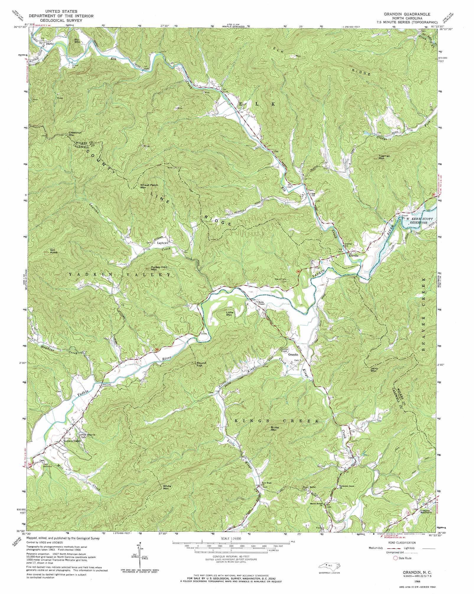
USGS Topo Quad 36081a4 - 1:24,000 scale
| Topo Map Name: | Grandin |
| USGS Topo Quad ID: | 36081a4 |
| Print Size: | ca. 21 1/4" wide x 27" high |
| Southeast Coordinates: | 36° N latitude / 81.375° W longitude |
| Map Center Coordinates: | 36.0625° N latitude / 81.4375° W longitude |
| U.S. State: | NC |
| Filename: | o36081a4.jpg |
| Download Map JPG Image: | Grandin topo map 1:24,000 scale |
| Map Type: | Topographic |
| Topo Series: | 7.5´ |
| Map Scale: | 1:24,000 |
| Source of Map Images: | United States Geological Survey (USGS) |
| Alternate Map Versions: |
Grandin NC 1966, updated 1968 Download PDF Buy paper map Grandin NC 2000, updated 2003 Download PDF Buy paper map Grandin NC 2010 Download PDF Buy paper map Grandin NC 2013 Download PDF Buy paper map Grandin NC 2016 Download PDF Buy paper map |
1:24,000 Topo Quads surrounding Grandin
Zionville |
Todd |
Glendale Springs |
Horse Gap |
Mcgrady |
Boone |
Deep Gap |
Maple Springs |
Purlear |
Wilkesboro |
Globe |
Buffalo Cove |
Grandin |
Boomer |
Moravian Falls |
Collettsville |
Lenoir |
Kings Creek |
Ellendale |
Taylorsville |
Morganton North |
Drexel |
Granite Falls |
Bethlehem |
Millersville |
> Back to 36081a1 at 1:100,000 scale
> Back to 36080a1 at 1:250,000 scale
> Back to U.S. Topo Maps home
Grandin topo map: Gazetteer
Grandin: Populated Places
Cilley (historical) elevation 358m 1174′Darby elevation 391m 1282′
Denny (historical) elevation 349m 1145′
Elkville elevation 334m 1095′
Fort Defiance elevation 365m 1197′
Grandin elevation 346m 1135′
Lenoir (historical) elevation 345m 1131′
Yadkin Valley elevation 355m 1164′
Grandin: Ranges
Warrior Mountains elevation 443m 1453′Grandin: Ridges
County Line Ridge elevation 724m 2375′Grandin: Streams
Blue Creek elevation 358m 1174′Dugger Creek elevation 385m 1263′
Elk Creek elevation 325m 1066′
Hawkins Creek elevation 345m 1131′
Kings Creek elevation 328m 1076′
Laytown Creek elevation 334m 1095′
Little Kings Creek elevation 335m 1099′
Mill Creek elevation 349m 1145′
Yates Creek elevation 340m 1115′
Grandin: Summits
Browns Mountain elevation 476m 1561′Butte Mountain elevation 626m 2053′
Chestnut Mountain elevation 750m 2460′
Gill Knob elevation 808m 2650′
Jerry Mountain elevation 653m 2142′
Little Mountain elevation 409m 1341′
Round Top elevation 550m 1804′
Sly Mountain elevation 495m 1624′
Tugman Mountain elevation 550m 1804′
Turkey Hen Mountain elevation 556m 1824′
Wheat Patch Mountain elevation 731m 2398′
White Mountain elevation 650m 2132′
Grandin digital topo map on disk
Buy this Grandin topo map showing relief, roads, GPS coordinates and other geographical features, as a high-resolution digital map file on DVD:
Western Virginia & Southern West Virginia
Buy digital topo maps: Western Virginia & Southern West Virginia