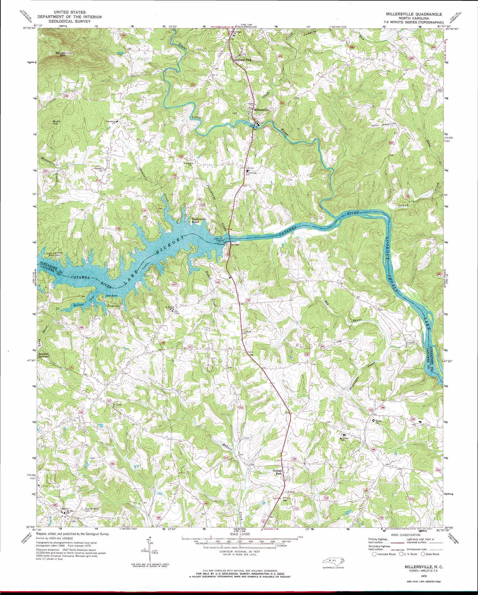
Millersville Topo Map North Carolina
To zoom in, hover over the map of Millersville
USGS Topo Quad 35081g2 - 1:24,000 scale
| Topo Map Name: | Millersville |
| USGS Topo Quad ID: | 35081g2 |
| Print Size: | ca. 21 1/4" wide x 27" high |
| Southeast Coordinates: | 35.75° N latitude / 81.125° W longitude |
| Map Center Coordinates: | 35.8125° N latitude / 81.1875° W longitude |
| U.S. State: | NC |
| Filename: | o35081g2.jpg |
| Download Map JPG Image: | Millersville topo map 1:24,000 scale |
| Map Type: | Topographic |
| Topo Series: | 7.5´ |
| Map Scale: | 1:24,000 |
| Source of Map Images: | United States Geological Survey (USGS) |
| Alternate Map Versions: |
Millersville NC 1970, updated 1973 Download PDF Buy paper map Millersville NC 1970, updated 1973 Download PDF Buy paper map Millersville NC 2010 Download PDF Buy paper map Millersville NC 2013 Download PDF Buy paper map Millersville NC 2016 Download PDF Buy paper map |
1:24,000 Topo Quads surrounding Millersville
Grandin |
Boomer |
Moravian Falls |
Gilreath |
Osbornville |
Kings Creek |
Ellendale |
Taylorsville |
Hiddenite |
Central |
Granite Falls |
Bethlehem |
Millersville |
Stony Point |
Statesville West |
Longview |
Hickory |
Newton |
Catawba |
Troutman |
Banoak |
Reepsville |
Maiden |
Denver |
Lake Norman North |
> Back to 35081e1 at 1:100,000 scale
> Back to 35080a1 at 1:250,000 scale
> Back to U.S. Topo Maps home
Millersville topo map: Gazetteer
Millersville: Airports
Alexander County Airport elevation 354m 1161′Millersville: Bays
Reitzel Cove elevation 284m 931′Millersville: Dams
North State Dam elevation 282m 925′Oxford Dam elevation 257m 843′
Ralph Flowers Dam elevation 271m 889′
Millersville: Populated Places
Isenhour Park elevation 319m 1046′Millersville elevation 293m 961′
Oxford Park elevation 300m 984′
Taylorsville Beach elevation 292m 958′
Millersville: Reservoirs
Lake Hickory elevation 277m 908′North State Lake elevation 282m 925′
Ralph Flowers Lake elevation 271m 889′
Millersville: Springs
Sulphur Springs elevation 299m 980′Millersville: Streams
Benfield Creek elevation 284m 931′Dellinger Creek elevation 257m 843′
Elk Shoal Creek elevation 256m 839′
Glade Creek elevation 270m 885′
Island Creek elevation 255m 836′
Jumping Run elevation 295m 967′
Long Shoal Creek elevation 284m 931′
Lower Little River elevation 255m 836′
Naked Creek elevation 284m 931′
Punchbowl Creek elevation 260m 853′
Millersville: Summits
Barrett Mountain elevation 572m 1876′Buck Hill elevation 397m 1302′
Millersville digital topo map on disk
Buy this Millersville topo map showing relief, roads, GPS coordinates and other geographical features, as a high-resolution digital map file on DVD:
South Carolina, Western North Carolina & Northeastern Georgia
Buy digital topo maps: South Carolina, Western North Carolina & Northeastern Georgia