Afton Ne Topo Map Oklahoma
To zoom in, hover over the map of Afton Ne
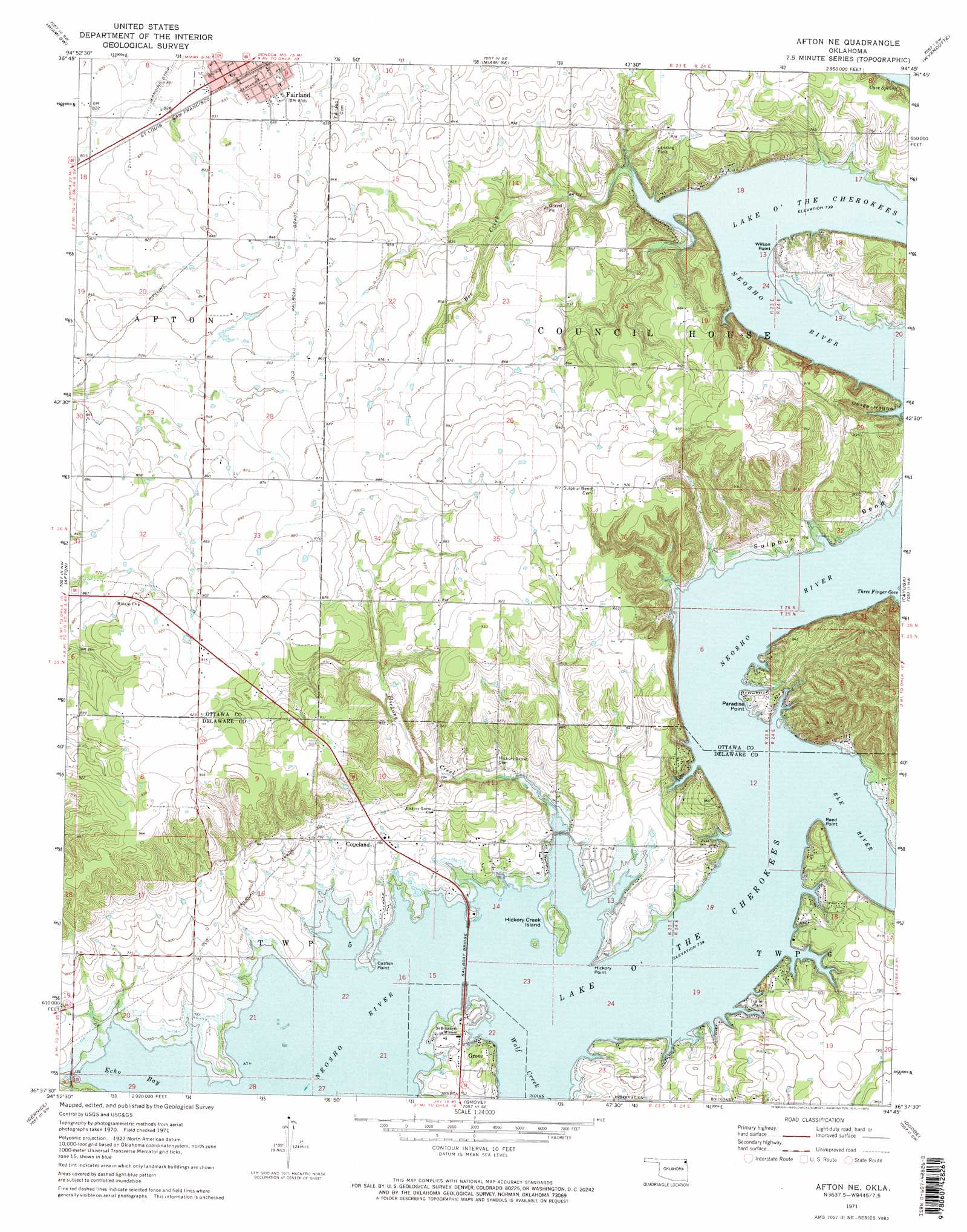
USGS Topo Quad 36094f7 - 1:24,000 scale
| Topo Map Name: | Afton Ne |
| USGS Topo Quad ID: | 36094f7 |
| Print Size: | ca. 21 1/4" wide x 27" high |
| Southeast Coordinates: | 36.625° N latitude / 94.75° W longitude |
| Map Center Coordinates: | 36.6875° N latitude / 94.8125° W longitude |
| U.S. State: | OK |
| Filename: | o36094f7.jpg |
| Download Map JPG Image: | Afton Ne topo map 1:24,000 scale |
| Map Type: | Topographic |
| Topo Series: | 7.5´ |
| Map Scale: | 1:24,000 |
| Source of Map Images: | United States Geological Survey (USGS) |
| Alternate Map Versions: |
Afton NE OK 1971, updated 1973 Download PDF Buy paper map Afton NE OK 2010 Download PDF Buy paper map Afton NE OK 2012 Download PDF Buy paper map Afton NE OK 2016 Download PDF Buy paper map |
1:24,000 Topo Quads surrounding Afton Ne
Welch North |
Miami Nw |
Picher |
Peoria |
Racine |
Welch South |
Miami Sw |
Miami Se |
Wyandotte |
Seneca |
Vinita Ne |
Afton |
Afton Ne |
Cayuga |
Tiff City |
Ketchum |
Bernice |
Grove |
Dodge |
South West City |
Spavinaw |
Chloeta |
Jay |
Sycamore |
Colcord Ne |
> Back to 36094e1 at 1:100,000 scale
> Back to 36094a1 at 1:250,000 scale
> Back to U.S. Topo Maps home
Afton Ne topo map: Gazetteer
Afton Ne: Airports
Green Country Airpark elevation 259m 849′Afton Ne: Bays
Echo Bay elevation 225m 738′Afton Ne: Bends
Sulphur Bend elevation 235m 770′Afton Ne: Bridges
Sail Boat Bridge elevation 225m 738′Afton Ne: Capes
Catfish Point elevation 227m 744′Hickory Point elevation 228m 748′
Paradise Point elevation 232m 761′
Reed Point elevation 245m 803′
Wilson Point elevation 236m 774′
Afton Ne: Islands
Hickory Creek Island elevation 232m 761′Afton Ne: Populated Places
Copeland elevation 241m 790′Afton Ne: Springs
Cave Spring elevation 227m 744′Afton Ne: Streams
Bee Creek elevation 239m 784′Elk River elevation 225m 738′
Hickory Creek elevation 225m 738′
Wolf Creek elevation 225m 738′
Afton Ne: Valleys
Osage Hollow elevation 225m 738′Afton Ne digital topo map on disk
Buy this Afton Ne topo map showing relief, roads, GPS coordinates and other geographical features, as a high-resolution digital map file on DVD: