Pearsonia Topo Map Oklahoma
To zoom in, hover over the map of Pearsonia
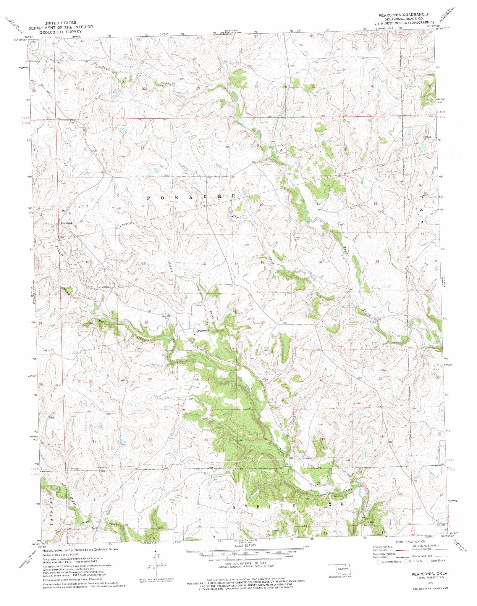
USGS Topo Quad 36096g4 - 1:24,000 scale
| Topo Map Name: | Pearsonia |
| USGS Topo Quad ID: | 36096g4 |
| Print Size: | ca. 21 1/4" wide x 27" high |
| Southeast Coordinates: | 36.75° N latitude / 96.375° W longitude |
| Map Center Coordinates: | 36.8125° N latitude / 96.4375° W longitude |
| U.S. State: | OK |
| Filename: | o36096g4.jpg |
| Download Map JPG Image: | Pearsonia topo map 1:24,000 scale |
| Map Type: | Topographic |
| Topo Series: | 7.5´ |
| Map Scale: | 1:24,000 |
| Source of Map Images: | United States Geological Survey (USGS) |
| Alternate Map Versions: |
Pearsonia OK 1973, updated 1975 Download PDF Buy paper map Pearsonia OK 2009 Download PDF Buy paper map Pearsonia OK 2012 Download PDF Buy paper map Pearsonia OK 2016 Download PDF Buy paper map |
1:24,000 Topo Quads surrounding Pearsonia
Dexter Sw |
Cedar Vale West |
Cedar Vale East |
Elgin |
Chautauqua |
Grainola |
Foraker North |
Pearsonia Nw |
Pearsonia Ne |
Whippoorwill |
Shidler |
Foraker South |
Pearsonia |
Nanos |
Herd |
Burbank |
Baconrind Creek |
Bluestem Lake |
Pawhuska |
Nelagoney |
Fairfax |
Lucy Creek |
Happy Hollow |
Wynona |
Barnsdall |
> Back to 36096e1 at 1:100,000 scale
> Back to 36096a1 at 1:250,000 scale
> Back to U.S. Topo Maps home
Pearsonia topo map: Gazetteer
Pearsonia: Dams
Oknoname 113117 Dam elevation 302m 990′Oknoname 113118 Dam elevation 327m 1072′
Oknoname 113119 Dam elevation 351m 1151′
Oknoname 113120 Dam elevation 339m 1112′
Oknoname 113121 Dam elevation 318m 1043′
Pearsonia: Populated Places
Blackland elevation 337m 1105′Myers elevation 262m 859′
Pearsonia elevation 313m 1026′
Pearsonia: Reservoirs
Oknoname 113117 Reservoir elevation 302m 990′Oknoname 113118 Reservoir elevation 327m 1072′
Oknoname 113119 Reservoir elevation 351m 1151′
Oknoname 113120 Reservoir elevation 339m 1112′
Oknoname 113121 Reservoir elevation 318m 1043′
Pearsonia: Streams
Dry Creek elevation 276m 905′Hickory Creek elevation 281m 921′
North Bird Creek elevation 279m 915′
Pearsonia digital topo map on disk
Buy this Pearsonia topo map showing relief, roads, GPS coordinates and other geographical features, as a high-resolution digital map file on DVD: