Barnsdall Topo Map Oklahoma
To zoom in, hover over the map of Barnsdall
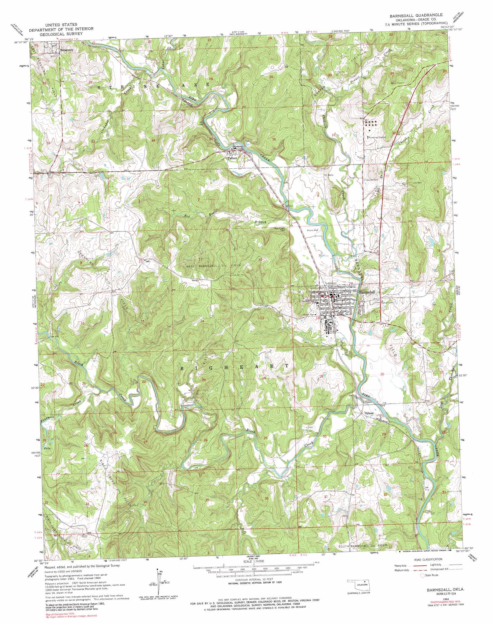
USGS Topo Quad 36096e2 - 1:24,000 scale
| Topo Map Name: | Barnsdall |
| USGS Topo Quad ID: | 36096e2 |
| Print Size: | ca. 21 1/4" wide x 27" high |
| Southeast Coordinates: | 36.5° N latitude / 96.125° W longitude |
| Map Center Coordinates: | 36.5625° N latitude / 96.1875° W longitude |
| U.S. State: | OK |
| Filename: | o36096e2.jpg |
| Download Map JPG Image: | Barnsdall topo map 1:24,000 scale |
| Map Type: | Topographic |
| Topo Series: | 7.5´ |
| Map Scale: | 1:24,000 |
| Source of Map Images: | United States Geological Survey (USGS) |
| Alternate Map Versions: |
Barnsdall OK 1964, updated 1965 Download PDF Buy paper map Barnsdall OK 1964, updated 1989 Download PDF Buy paper map Barnsdall OK 2010 Download PDF Buy paper map Barnsdall OK 2012 Download PDF Buy paper map Barnsdall OK 2016 Download PDF Buy paper map |
1:24,000 Topo Quads surrounding Barnsdall
Pearsonia |
Nanos |
Herd |
Bowring Se |
Bartlesville North |
Bluestem Lake |
Pawhuska |
Nelagoney |
Woolaroc |
Bartlesville South |
Happy Hollow |
Wynona |
Barnsdall |
Wolco |
Ramona |
Hominy |
Hominy Ne |
Avant Nw |
Avant |
Vera |
Cleveland |
New Prue |
Avant Sw |
Avant Se |
Sperry |
> Back to 36096e1 at 1:100,000 scale
> Back to 36096a1 at 1:250,000 scale
> Back to U.S. Topo Maps home
Barnsdall topo map: Gazetteer
Barnsdall: Dams
Birch Dam elevation 212m 695′Fort Gibson Dam elevation 212m 695′
Oknoname 113071 Dam elevation 224m 734′
Oknoname 113072 Dam elevation 250m 820′
Oknoname 113073 Dam elevation 240m 787′
Barnsdall: Oilfields
Barnsdall Oil Field elevation 227m 744′Birch Creek Oil Field elevation 297m 974′
Birch Creek South Oil Field elevation 278m 912′
East Pershing Oil Field elevation 249m 816′
Quapaw Oil Field elevation 248m 813′
West Barnsdall Oil Field elevation 270m 885′
Barnsdall: Populated Places
Barnsdall elevation 226m 741′Gilland elevation 223m 731′
Nichols elevation 233m 764′
Tallant elevation 229m 751′
Barnsdall: Reservoirs
Birch Lake elevation 212m 695′Birch Reservoir elevation 236m 774′
Fort Gibson Reservoir elevation 212m 695′
Oknoname 113071 Reservoir elevation 224m 734′
Oknoname 113072 Reservoir elevation 250m 820′
Oknoname 113073 Reservoir elevation 240m 787′
Barnsdall: Streams
Birch Creek elevation 214m 702′Cedar Creek elevation 222m 728′
Choteau Creek elevation 216m 708′
Cochahee Creek elevation 230m 754′
Dog Thresher Creek elevation 209m 685′
East Choteau Creek elevation 221m 725′
Fourmile Creek elevation 228m 748′
Pennel Creek elevation 228m 748′
Red Eagle Branch elevation 219m 718′
Barnsdall digital topo map on disk
Buy this Barnsdall topo map showing relief, roads, GPS coordinates and other geographical features, as a high-resolution digital map file on DVD: