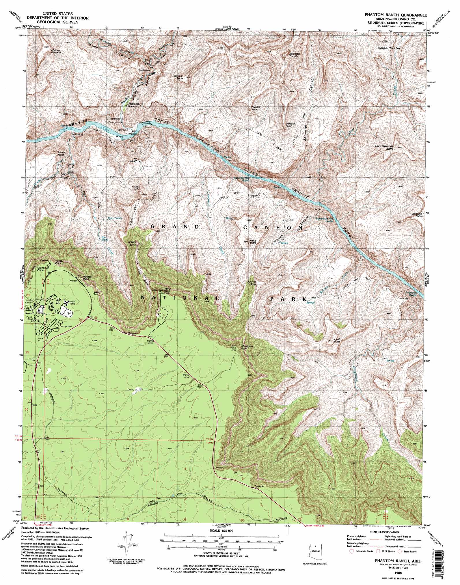
Phantom Ranch Topo Map Arizona
To zoom in, hover over the map of Phantom Ranch
USGS Topo Quad 36112a1 - 1:24,000 scale
| Topo Map Name: | Phantom Ranch |
| USGS Topo Quad ID: | 36112a1 |
| Print Size: | ca. 21 1/4" wide x 27" high |
| Southeast Coordinates: | 36° N latitude / 112° W longitude |
| Map Center Coordinates: | 36.0625° N latitude / 112.0625° W longitude |
| U.S. State: | AZ |
| Filename: | o36112a1.jpg |
| Download Map JPG Image: | Phantom Ranch topo map 1:24,000 scale |
| Map Type: | Topographic |
| Topo Series: | 7.5´ |
| Map Scale: | 1:24,000 |
| Source of Map Images: | United States Geological Survey (USGS) |
| Alternate Map Versions: |
Phantom Ranch AZ 1988, updated 1988 Download PDF Buy paper map Phantom Ranch AZ 1988, updated 1988 Download PDF Buy paper map Phantom Ranch AZ 2011 Download PDF Buy paper map Phantom Ranch AZ 2014 Download PDF Buy paper map |
| FStopo: | US Forest Service topo Phantom Ranch is available: Download FStopo PDF Download FStopo TIF |
1:24,000 Topo Quads surrounding Phantom Ranch
King Arthur Castle |
Kanabownits Spring |
Little Park Lake |
Point Imperial |
Nankoweap Mesa |
Havasupai Point |
Shiva Temple |
Bright Angel Point |
Walhalla Plateau |
Cape Solitude |
Piute Point |
Grand Canyon |
Phantom Ranch |
Cape Royal |
Desert View |
Metzger Tank |
Tusayan West |
Tusayan East |
Grandview Point |
Grandview Point Ne |
Howard Hill |
Red Butte Sw |
Red Butte |
Harbison Tank |
Peterson Flat |
> Back to 36112a1 at 1:100,000 scale
> Back to 36112a1 at 1:250,000 scale
> Back to U.S. Topo Maps home
Phantom Ranch topo map: Gazetteer
Phantom Ranch: Arches
Natural Arch elevation 1519m 4983′Phantom Ranch: Basins
Ottoman Amphitheater elevation 1308m 4291′Phantom Ranch: Bridges
Kaibab Suspension Bridge elevation 738m 2421′Silver Bridge elevation 735m 2411′
Phantom Ranch: Cliffs
Bradley Point elevation 1463m 4799′Demaray Point elevation 1368m 4488′
Mather Point elevation 2170m 7119′
Plateau Point elevation 1155m 3789′
Shoshone Point elevation 0m 0′
Yaki Point elevation 2213m 7260′
Yavapai Point elevation 2085m 6840′
Phantom Ranch: Flats
Indian Garden elevation 1488m 4881′Phantom Ranch: Rapids
Eightyfive Mile Rapids elevation 749m 2457′Eightythree Mile Rapids elevation 754m 2473′
Grapevine Rapids elevation 766m 2513′
Phantom Ranch: Reservoirs
Holloway Tank elevation 769m 2522′Phantom Ranch: Ridges
Cedar Ridge elevation 1857m 6092′Phantom Ranch: Springs
Burro Spring elevation 1135m 3723′Pipe Spring elevation 1120m 3674′
Phantom Ranch: Streams
Boulder Creek elevation 765m 2509′Bright Angel Creek elevation 742m 2434′
Clear Creek elevation 751m 2463′
Cremation Creek elevation 763m 2503′
Garden Creek elevation 861m 2824′
Grapevine Creek elevation 831m 2726′
Phantom Creek elevation 871m 2857′
Pipe Creek elevation 737m 2417′
Phantom Ranch: Summits
Berry Butte elevation 1729m 5672′Cheops Pyramid elevation 1637m 5370′
Grandeur Point elevation 2145m 7037′
Hawkins Butte elevation 1579m 5180′
Lyell Butte elevation 1608m 5275′
Newton Butte elevation 1781m 5843′
O'Neill Butte elevation 1775m 5823′
Pattie Butte elevation 1563m 5127′
Sumner Butte elevation 1562m 5124′
Sumner Point elevation 1560m 5118′
The Howlands Butte elevation 1664m 5459′
The Tipoff elevation 1203m 3946′
Zoroaster Temple elevation 2172m 7125′
Phantom Ranch: Trails
Clear Creek Trail elevation 1161m 3809′River Trail elevation 786m 2578′
South Kaibab Trail elevation 865m 2837′
Phantom Ranch: Valleys
Bright Angel Canyon elevation 785m 2575′Lonetree Canyon elevation 836m 2742′
Phantom Canyon elevation 893m 2929′
The Box elevation 930m 3051′
Zoroaster Canyon elevation 788m 2585′
Phantom Ranch digital topo map on disk
Buy this Phantom Ranch topo map showing relief, roads, GPS coordinates and other geographical features, as a high-resolution digital map file on DVD: