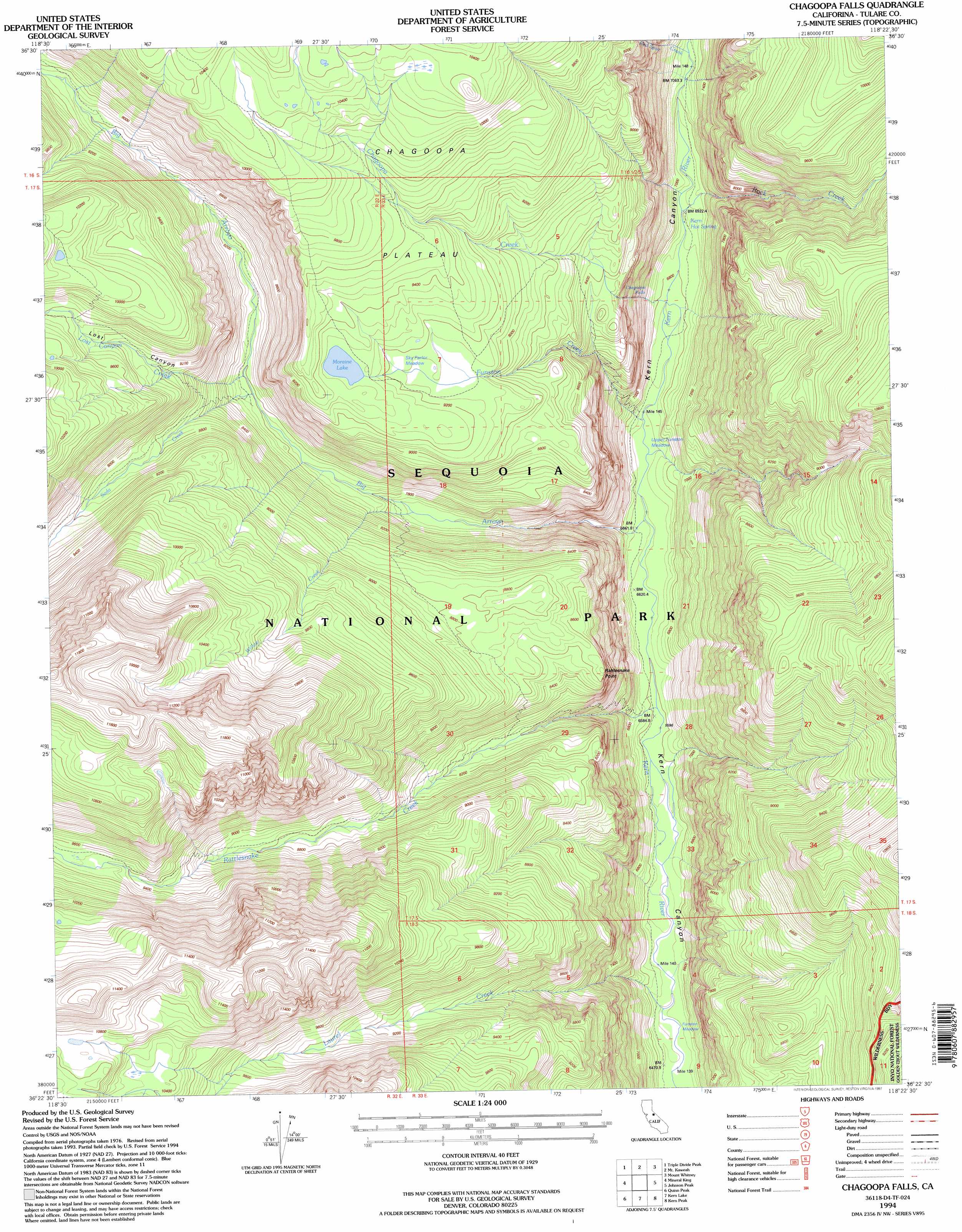
Chagoopa Falls Topo Map California
To zoom in, hover over the map of Chagoopa Falls
USGS Topo Quad 36118d4 - 1:24,000 scale
| Topo Map Name: | Chagoopa Falls |
| USGS Topo Quad ID: | 36118d4 |
| Print Size: | ca. 21 1/4" wide x 27" high |
| Southeast Coordinates: | 36.375° N latitude / 118.375° W longitude |
| Map Center Coordinates: | 36.4375° N latitude / 118.4375° W longitude |
| U.S. State: | CA |
| Filename: | o36118d4.jpg |
| Download Map JPG Image: | Chagoopa Falls topo map 1:24,000 scale |
| Map Type: | Topographic |
| Topo Series: | 7.5´ |
| Map Scale: | 1:24,000 |
| Source of Map Images: | United States Geological Survey (USGS) |
| Alternate Map Versions: |
Chagoopa Falls CA 1988, updated 1988 Download PDF Buy paper map Chagoopa Falls CA 1988, updated 1994 Download PDF Buy paper map Chagoopa Falls CA 1994, updated 1997 Download PDF Buy paper map Chagoopa Falls CA 2012 Download PDF Buy paper map Chagoopa Falls CA 2015 Download PDF Buy paper map |
| FStopo: | US Forest Service topo Chagoopa Falls is available: Download FStopo PDF Download FStopo TIF |
1:24,000 Topo Quads surrounding Chagoopa Falls
Mount Stillman |
Sphinx Lakes |
Mount Brewer |
Mount Williamson |
Manzanar |
Lodgepole |
Triple Divide Peak |
Mount Kaweah |
Mount Whitney |
Mount Langley |
Silver City |
Mineral King |
Chagoopa Falls |
Johnson Peak |
Cirque Peak |
Moses Mountain |
Quinn Peak |
Kern Lake |
Kern Peak |
Templeton Mountain |
Camp Wishon |
Camp Nelson |
Hockett Peak |
Casa Vieja Meadows |
Monache Mountain |
> Back to 36118a1 at 1:100,000 scale
> Back to 36118a1 at 1:250,000 scale
> Back to U.S. Topo Maps home
Chagoopa Falls topo map: Gazetteer
Chagoopa Falls: Cliffs
Window Cliffs elevation 3157m 10357′Chagoopa Falls: Falls
Chagoopa Falls elevation 2076m 6811′Chagoopa Falls: Flats
Funston Meadow elevation 1974m 6476′Sky Parlor Meadow elevation 2786m 9140′
Upper Funston Meadow elevation 2092m 6863′
Chagoopa Falls: Lakes
Moraine Lake elevation 2838m 9311′Chagoopa Falls: Plains
Chagoopa Plateau elevation 2965m 9727′Chagoopa Falls: Springs
Kern Hot Spring elevation 2104m 6902′Chagoopa Falls: Streams
Big Arroyo elevation 2024m 6640′Chagoopa Creek elevation 2071m 6794′
Funston Creek elevation 2035m 6676′
Laurel Creek elevation 1976m 6482′
Lost Canyon Creek elevation 2441m 8008′
Rattlesnake Creek elevation 2007m 6584′
Red Spur Creek elevation 2164m 7099′
Rock Creek elevation 2107m 6912′
Soda Creek elevation 2433m 7982′
Willow Creek elevation 2361m 7746′
Chagoopa Falls: Valleys
Lost Canyon elevation 2477m 8126′Chagoopa Falls digital topo map on disk
Buy this Chagoopa Falls topo map showing relief, roads, GPS coordinates and other geographical features, as a high-resolution digital map file on DVD:
Southern Sierra Nevada, California & Southern Nevada
Buy digital topo maps: Southern Sierra Nevada, California & Southern Nevada