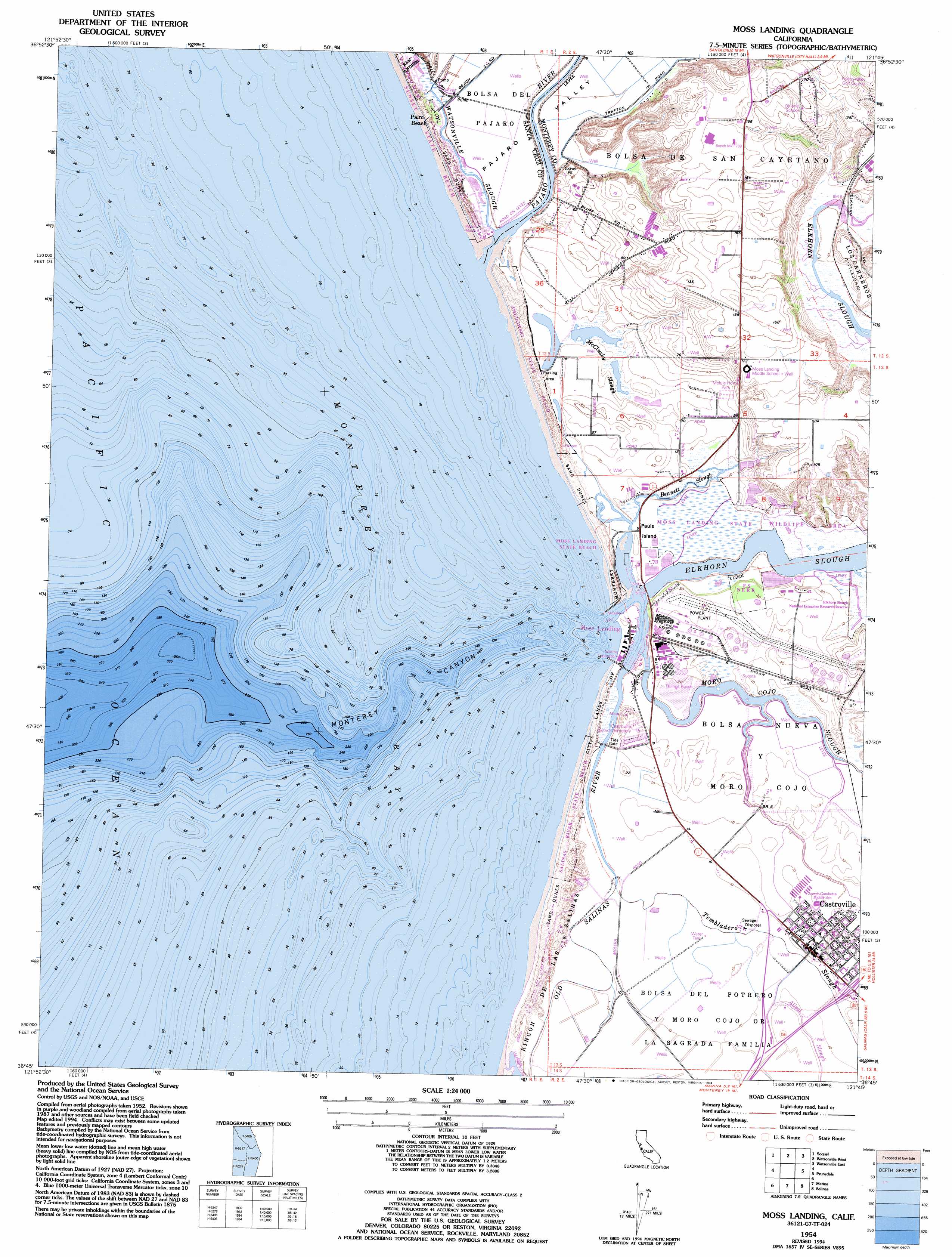
Moss Landing Topo Map California
To zoom in, hover over the map of Moss Landing
USGS Topo Quad 36121g7 - 1:24,000 scale
| Topo Map Name: | Moss Landing |
| USGS Topo Quad ID: | 36121g7 |
| Print Size: | ca. 21 1/4" wide x 27" high |
| Southeast Coordinates: | 36.75° N latitude / 121.75° W longitude |
| Map Center Coordinates: | 36.8125° N latitude / 121.8125° W longitude |
| U.S. State: | CA |
| Filename: | o36121g7.jpg |
| Download Map JPG Image: | Moss Landing topo map 1:24,000 scale |
| Map Type: | Topographic |
| Topo Series: | 7.5´ |
| Map Scale: | 1:24,000 |
| Source of Map Images: | United States Geological Survey (USGS) |
| Alternate Map Versions: |
Moss Landing CA 1954, updated 1955 Download PDF Buy paper map Moss Landing CA 1954, updated 1965 Download PDF Buy paper map Moss Landing CA 1954, updated 1973 Download PDF Buy paper map Moss Landing CA 1954, updated 1980 Download PDF Buy paper map Moss Landing CA 1954, updated 1984 Download PDF Buy paper map Moss Landing CA 1954, updated 1994 Download PDF Buy paper map Moss Landing CA 2012 Download PDF Buy paper map Moss Landing CA 2015 Download PDF Buy paper map |
1:24,000 Topo Quads surrounding Moss Landing
Felton |
Laurel |
Loma Prieta |
Mount Madonna |
Gilroy |
Santa Cruz |
Soquel |
Watsonville West |
Watsonville East |
Chittenden |
Moss Landing |
Prunedale |
San Juan Bautista |
||
Marina |
Salinas |
Natividad |
||
Monterey |
Seaside |
Spreckels |
Chualar |
> Back to 36121e1 at 1:100,000 scale
> Back to 36120a1 at 1:250,000 scale
> Back to U.S. Topo Maps home
Moss Landing topo map: Gazetteer
Moss Landing: Beaches
Island Beach elevation 2m 6′Jetty Beach elevation 2m 6′
Moss Landing: Bridges
Sandholt Bridge elevation -1m -4′Moss Landing: Canals
Entrance Channel elevation 0m 0′Inner Channel elevation 0m 0′
Moss Landing: Guts
Bennett Slough elevation 2m 6′McClusky Slough elevation 2m 6′
Old Salinas River elevation 2m 6′
Moss Landing: Harbors
Moss Landing Harbor elevation 0m 0′Moss Landing: Islands
Pauls Island elevation 2m 6′Moss Landing: Parks
Moss Landing State Beach elevation 5m 16′Moss Landing State Wildlife Area elevation 3m 9′
Salinas River State Beach elevation 4m 13′
Zmudowski Beach State Park elevation 7m 22′
Moss Landing: Populated Places
Castroville elevation 7m 22′Moss elevation 1m 3′
Moss Landing elevation 3m 9′
Port Watsonville (historical) elevation 2m 6′
Moss Landing: Post Offices
Castroville Post Office elevation 4m 13′Moss Landing Post Office elevation 1m 3′
Moss Landing: Streams
Elkhorn Slough elevation 0m 0′Moro Cojo Slough elevation 0m 0′
Pajaro River elevation 0m 0′
Tembladero Slough elevation 1m 3′
Watsonville Slough elevation 0m 0′
Moss Landing: Valleys
Monterey Canyon elevation 0m 0′Pajaro Valley elevation 2m 6′
Moss Landing digital topo map on disk
Buy this Moss Landing topo map showing relief, roads, GPS coordinates and other geographical features, as a high-resolution digital map file on DVD: