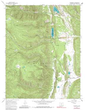
Stonewall Topo Map Colorado
To zoom in, hover over the map of Stonewall
USGS Topo Quad 37105b1 - 1:24,000 scale
| Topo Map Name: | Stonewall |
| USGS Topo Quad ID: | 37105b1 |
| Print Size: | ca. 21 1/4" wide x 27" high |
| Southeast Coordinates: | 37.125° N latitude / 105° W longitude |
| Map Center Coordinates: | 37.1875° N latitude / 105.0625° W longitude |
| U.S. State: | CO |
| Filename: | o37105b1.jpg |
| Download Map JPG Image: | Stonewall topo map 1:24,000 scale |
| Map Type: | Topographic |
| Topo Series: | 7.5´ |
| Map Scale: | 1:24,000 |
| Source of Map Images: | United States Geological Survey (USGS) |
| Alternate Map Versions: |
Stonewall CO 1967, updated 1971 Download PDF Buy paper map Stonewall CO 1967, updated 1981 Download PDF Buy paper map Stonewall CO 1994, updated 1998 Download PDF Buy paper map Stonewall CO 2011 Download PDF Buy paper map Stonewall CO 2013 Download PDF Buy paper map Stonewall CO 2016 Download PDF Buy paper map |
| FStopo: | US Forest Service topo Stonewall is available: Download FStopo PDF Download FStopo TIF |
1:24,000 Topo Quads surrounding Stonewall
> Back to 37105a1 at 1:100,000 scale
> Back to 37104a1 at 1:250,000 scale
> Back to U.S. Topo Maps home
Stonewall topo map: Gazetteer
Stonewall: Basins
South Valley elevation 2407m 7896′Stonewall: Dams
Monument Lake Dam elevation 2615m 8579′North Lake Dam elevation 2610m 8562′
Russell Dam elevation 2378m 7801′
Stonewall: Flats
Brown Park elevation 3380m 11089′Coal Creek Flat elevation 2538m 8326′
Duling Park elevation 2949m 9675′
Wilkens Park elevation 3020m 9908′
Wilkins Park elevation 3014m 9888′
Stonewall: Lakes
Brown Lake elevation 3387m 11112′Duling Lakes elevation 2980m 9776′
Rainbow Lake elevation 2456m 8057′
Russell Lake elevation 2378m 7801′
Schaffer Lake elevation 2625m 8612′
Stonewall: Populated Places
Monument Park elevation 2620m 8595′Stonewall elevation 2358m 7736′
Stonewall Gap elevation 2417m 7929′
Stonewall: Reservoirs
Monument Lake elevation 2615m 8579′North Lake elevation 2610m 8562′
Russell Reservoir elevation 2378m 7801′
South Lake elevation 2398m 7867′
Stonewall: Ridges
The Stonewall elevation 2582m 8471′Stonewall: Streams
Abbot Creek elevation 2477m 8126′Brown Creek elevation 2439m 8001′
Cherry Creek elevation 2486m 8156′
Crooked Creek elevation 2329m 7641′
Duling Creek elevation 2447m 8028′
Howlett Creek elevation 2548m 8359′
West Fork North Fork Purgatoire River elevation 2910m 9547′
Whiskey Creek elevation 2421m 7942′
Wilkins Creek elevation 2424m 7952′
Stonewall: Summits
Hayrack Mountain elevation 2623m 8605′Stonewall: Valleys
Deadman Canyon elevation 2456m 8057′Dry Canyon elevation 2486m 8156′
Frank Canyon elevation 2541m 8336′
Hell Canyon elevation 2653m 8704′
Romain Canyon elevation 2375m 7791′
Sheep Canyon elevation 2454m 8051′
Stonewall digital topo map on disk
Buy this Stonewall topo map showing relief, roads, GPS coordinates and other geographical features, as a high-resolution digital map file on DVD:


