Trinchera Ranch Topo Map Colorado
To zoom in, hover over the map of Trinchera Ranch
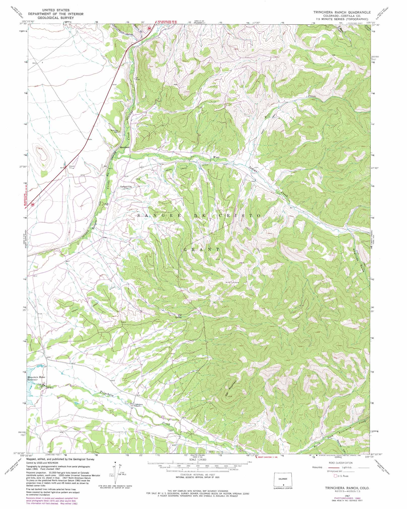
USGS Topo Quad 37105d3 - 1:24,000 scale
| Topo Map Name: | Trinchera Ranch |
| USGS Topo Quad ID: | 37105d3 |
| Print Size: | ca. 21 1/4" wide x 27" high |
| Southeast Coordinates: | 37.375° N latitude / 105.25° W longitude |
| Map Center Coordinates: | 37.4375° N latitude / 105.3125° W longitude |
| U.S. State: | CO |
| Filename: | o37105d3.jpg |
| Download Map JPG Image: | Trinchera Ranch topo map 1:24,000 scale |
| Map Type: | Topographic |
| Topo Series: | 7.5´ |
| Map Scale: | 1:24,000 |
| Source of Map Images: | United States Geological Survey (USGS) |
| Alternate Map Versions: |
Trinchera Ranch CO 1967, updated 1971 Download PDF Buy paper map Trinchera Ranch CO 1967, updated 1971 Download PDF Buy paper map Trinchera Ranch CO 2010 Download PDF Buy paper map Trinchera Ranch CO 2013 Download PDF Buy paper map Trinchera Ranch CO 2016 Download PDF Buy paper map |
1:24,000 Topo Quads surrounding Trinchera Ranch
Zapata Ranch |
Mosca Pass |
Red Wing |
Little Sheep Mountain |
Farisita |
Twin Peaks |
Blanca Peak |
Russell |
La Veta Pass |
La Veta |
Blanca |
Fort Garland |
Trinchera Ranch |
Mccarty Park |
Cuchara |
Blanca Se |
Fort Garland Sw |
Ojito Peak |
Trinchera Peak |
Cucharas Pass |
San Acacio |
San Luis |
Taylor Ranch |
El Valle Creek |
Stonewall |
> Back to 37105a1 at 1:100,000 scale
> Back to 37104a1 at 1:250,000 scale
> Back to U.S. Topo Maps home
Trinchera Ranch topo map: Gazetteer
Trinchera Ranch: Canals
Indian Creek Ditch elevation 2520m 8267′Trinchera Ranch: Populated Places
Garland City (historical) elevation 2476m 8123′Trinchera Ranch: Springs
Cat Spring elevation 2644m 8674′Trinchera Ranch: Streams
Bear Creek elevation 2534m 8313′West Indian Creek elevation 2464m 8083′
Trinchera Ranch: Summits
Cat Mountain elevation 3039m 9970′Trinchera Ranch: Valleys
American Gulch elevation 2613m 8572′Cottonwood Gulch elevation 2506m 8221′
Sawmill Gulch elevation 2500m 8202′
Squirrel Canyon elevation 2672m 8766′
Trinchera Ranch digital topo map on disk
Buy this Trinchera Ranch topo map showing relief, roads, GPS coordinates and other geographical features, as a high-resolution digital map file on DVD: