Chromo Topo Map Colorado
To zoom in, hover over the map of Chromo
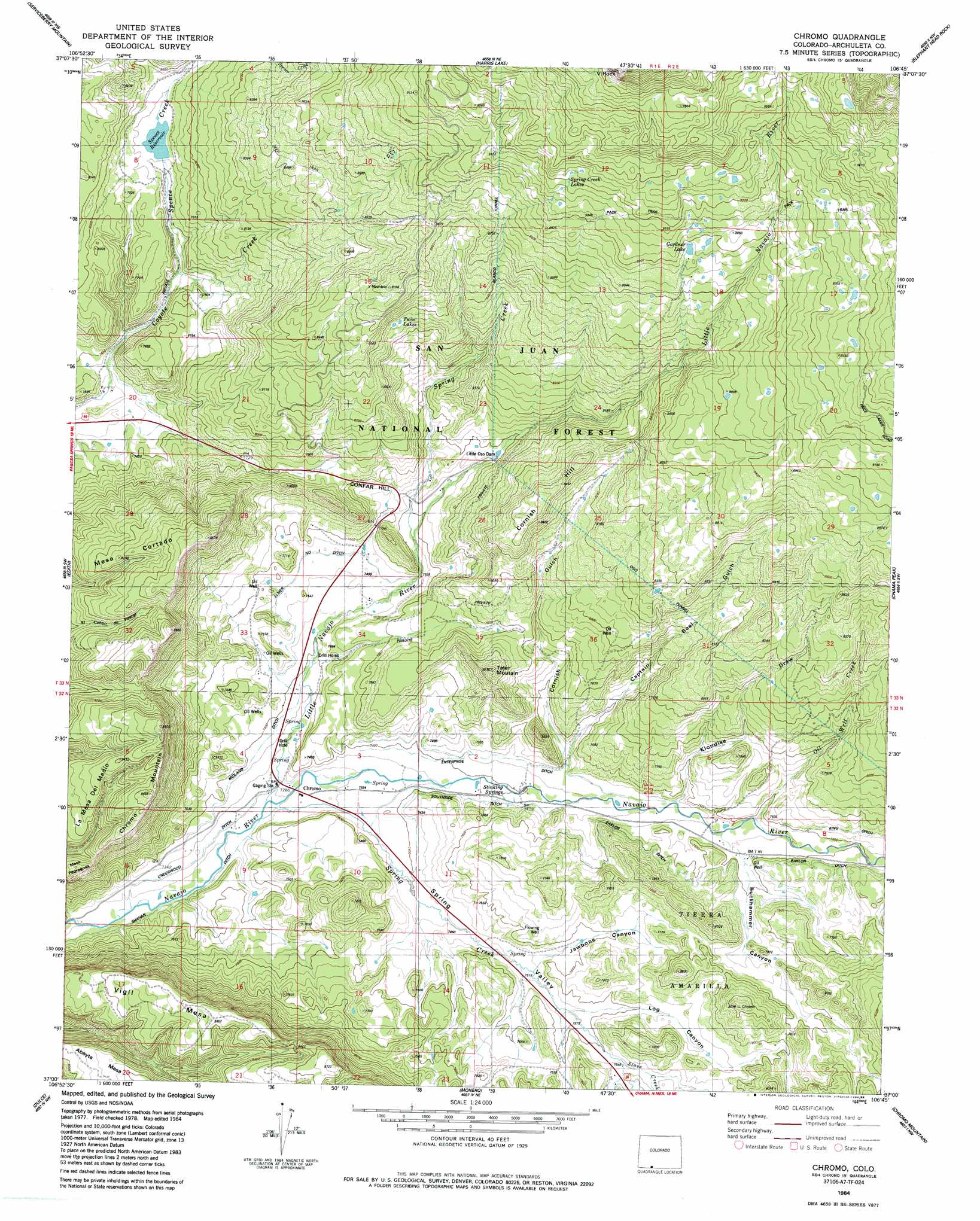
USGS Topo Quad 37106a7 - 1:24,000 scale
| Topo Map Name: | Chromo |
| USGS Topo Quad ID: | 37106a7 |
| Print Size: | ca. 21 1/4" wide x 27" high |
| Southeast Coordinates: | 37° N latitude / 106.75° W longitude |
| Map Center Coordinates: | 37.0625° N latitude / 106.8125° W longitude |
| U.S. State: | CO |
| Filename: | o37106a7.jpg |
| Download Map JPG Image: | Chromo topo map 1:24,000 scale |
| Map Type: | Topographic |
| Topo Series: | 7.5´ |
| Map Scale: | 1:24,000 |
| Source of Map Images: | United States Geological Survey (USGS) |
| Alternate Map Versions: |
Chromo CO 1984, updated 1984 Download PDF Buy paper map Chromo CO 1984, updated 1988 Download PDF Buy paper map Chromo CO 2011 Download PDF Buy paper map Chromo CO 2013 Download PDF Buy paper map Chromo CO 2016 Download PDF Buy paper map |
| FStopo: | US Forest Service topo Chromo is available: Download FStopo PDF Download FStopo TIF |
1:24,000 Topo Quads surrounding Chromo
Pagosa Springs |
Jackson Mountain |
Blackhead Peak |
Summit Peak |
Platoro |
Oakbrush Hill |
Serviceberry Mountain |
Harris Lake |
Elephant Head Rock |
Victoria Lake |
Trujillo |
Edith |
Chromo |
Chama Peak |
Archuleta Creek |
Wirt Canyon |
Dulce |
Monero |
Chromo Mountain |
Chama |
John Mills Lake |
Cordova Canyon |
Horse Lake |
Sawmill Mesa |
Brazos |
> Back to 37106a1 at 1:100,000 scale
> Back to 37106a1 at 1:250,000 scale
> Back to U.S. Topo Maps home
Chromo topo map: Gazetteer
Chromo: Canals
Eaklor Ditch elevation 2338m 7670′Elmer Ditch elevation 2294m 7526′
Enterprise Ditch elevation 2276m 7467′
Midland Ditch elevation 2250m 7381′
Southside Ditch elevation 2256m 7401′
Underwood Ditch elevation 2221m 7286′
Chromo: Cliffs
V Rock elevation 3140m 10301′Chromo: Dams
Little Oso Dam elevation 2369m 7772′Sappington Dam elevation 2368m 7769′
Spence Dam elevation 2393m 7851′
Chromo: Lakes
Gardner Lake elevation 2731m 8959′Spring Creek Lakes elevation 2806m 9206′
Twin Lakes elevation 2545m 8349′
Chromo: Populated Places
Chromo elevation 2220m 7283′Chromo: Reservoirs
Sappington Reservoir elevation 2368m 7769′Spence Reservoir elevation 2393m 7851′
Chromo: Ridges
Shahan Ditch elevation 2213m 7260′Chromo: Springs
Stinking Springs elevation 2271m 7450′Chromo: Streams
Little Navajo River elevation 2218m 7276′Oil Well Creek elevation 2301m 7549′
Spence Creek elevation 2338m 7670′
Spring Creek elevation 2213m 7260′
Spring Creek elevation 2305m 7562′
Stove Creek elevation 2303m 7555′
Chromo: Summits
Abeyta Mesa elevation 2487m 8159′Chromo Mountain elevation 2620m 8595′
Cornish Hill elevation 2592m 8503′
La Mesa del Medio elevation 2559m 8395′
Mesa Cortado elevation 2604m 8543′
Mesa Pedregosa elevation 2480m 8136′
Tater Mountain elevation 2505m 8218′
Vigil Mesa elevation 2661m 8730′
Chromo: Tunnels
Oso Tunnel elevation 2520m 8267′Chromo: Valleys
Buckhammer Canyon elevation 2313m 7588′Captain Beal Gulch elevation 2279m 7477′
Cornish Gulch elevation 2278m 7473′
Jawbone Canyon elevation 2298m 7539′
Klondike Draw elevation 2293m 7522′
Log Canyon elevation 2311m 7582′
Spring Valley elevation 2220m 7283′
Chromo digital topo map on disk
Buy this Chromo topo map showing relief, roads, GPS coordinates and other geographical features, as a high-resolution digital map file on DVD: