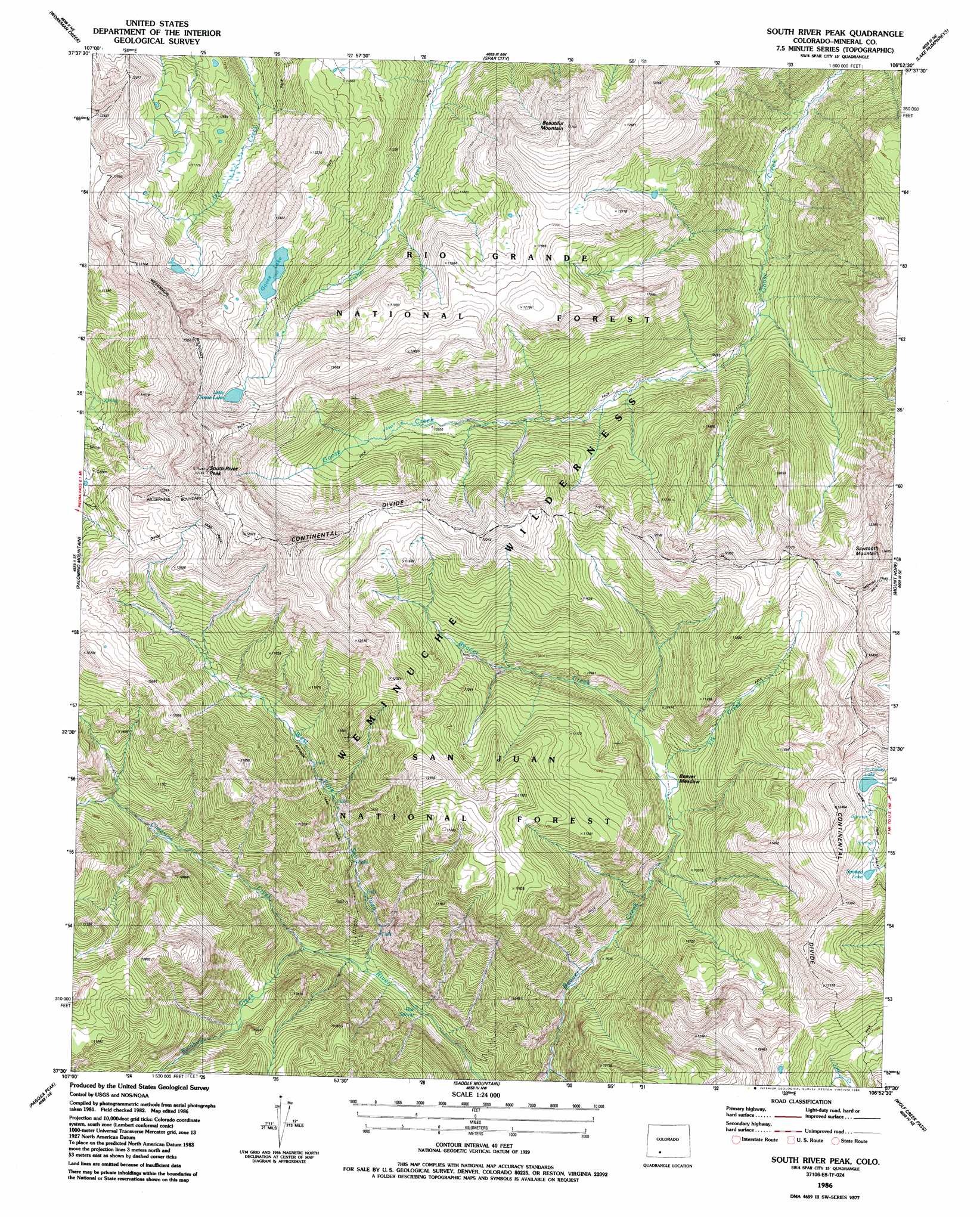
South River Creek Topo Map Colorado
To zoom in, hover over the map of South River Creek
USGS Topo Quad 37106e8 - 1:24,000 scale
| Topo Map Name: | South River Creek |
| USGS Topo Quad ID: | 37106e8 |
| Print Size: | ca. 21 1/4" wide x 27" high |
| Southeast Coordinates: | 37.5° N latitude / 106.875° W longitude |
| Map Center Coordinates: | 37.5625° N latitude / 106.9375° W longitude |
| U.S. State: | CO |
| Filename: | o37106e8.jpg |
| Download Map JPG Image: | South River Creek topo map 1:24,000 scale |
| Map Type: | Topographic |
| Topo Series: | 7.5´ |
| Map Scale: | 1:24,000 |
| Source of Map Images: | United States Geological Survey (USGS) |
| Alternate Map Versions: |
South River Peak CO 1986, updated 1986 Download PDF Buy paper map South River Peak CO 2001, updated 2005 Download PDF Buy paper map South River Peak CO 2011 Download PDF Buy paper map South River Peak CO 2013 Download PDF Buy paper map South River Peak CO 2016 Download PDF Buy paper map |
| FStopo: | US Forest Service topo South River Peak is available: Download FStopo PDF Download FStopo TIF |
1:24,000 Topo Quads surrounding South River Creek
Hermit Lakes |
Bristol Head |
Creede |
Wagon Wheel Gap |
Pool Table Mountain |
Little Squaw Creek |
Workman Creek |
Spar City |
Lake Humphreys |
South Fork West |
Cimarrona Peak |
Palomino Mountain |
South River Creek |
Mount Hope |
Beaver Creek Reservoir |
Oakbrush Ridge |
Pagosa Peak |
Saddle Mountain |
Wolf Creek Pass |
Elwood Pass |
Chris Mountain |
Pagosa Springs |
Jackson Mountain |
Blackhead Peak |
Summit Peak |
> Back to 37106e1 at 1:100,000 scale
> Back to 37106a1 at 1:250,000 scale
> Back to U.S. Topo Maps home
South River Creek topo map: Gazetteer
South River Creek: Dams
Goose Lake Dam elevation 3708m 12165′South River Creek: Flats
Beaver Meadow elevation 3059m 10036′South River Creek: Lakes
Archuleta Lake elevation 3579m 11742′Goose Lake elevation 3599m 11807′
Spotted Lake elevation 3558m 11673′
South River Creek: Reservoirs
Goose Reservoir elevation 3708m 12165′Little Goose Lake elevation 3729m 12234′
South River Creek: Springs
Hot Springs elevation 2759m 9051′Rainbow Hot Springs elevation 2924m 9593′
South River Creek: Streams
Cimarron Creek elevation 2768m 9081′Elk Creek elevation 3058m 10032′
Rainbow Creek elevation 2822m 9258′
South River Creek: Summits
Beautiful Mountain elevation 3854m 12644′Sawtooth Mountain elevation 3833m 12575′
South River Peak elevation 3994m 13103′
South River Creek: Trails
Rainbow Trail elevation 3279m 10757′South River Creek digital topo map on disk
Buy this South River Creek topo map showing relief, roads, GPS coordinates and other geographical features, as a high-resolution digital map file on DVD: