Elwood Pass Topo Map Colorado
To zoom in, hover over the map of Elwood Pass
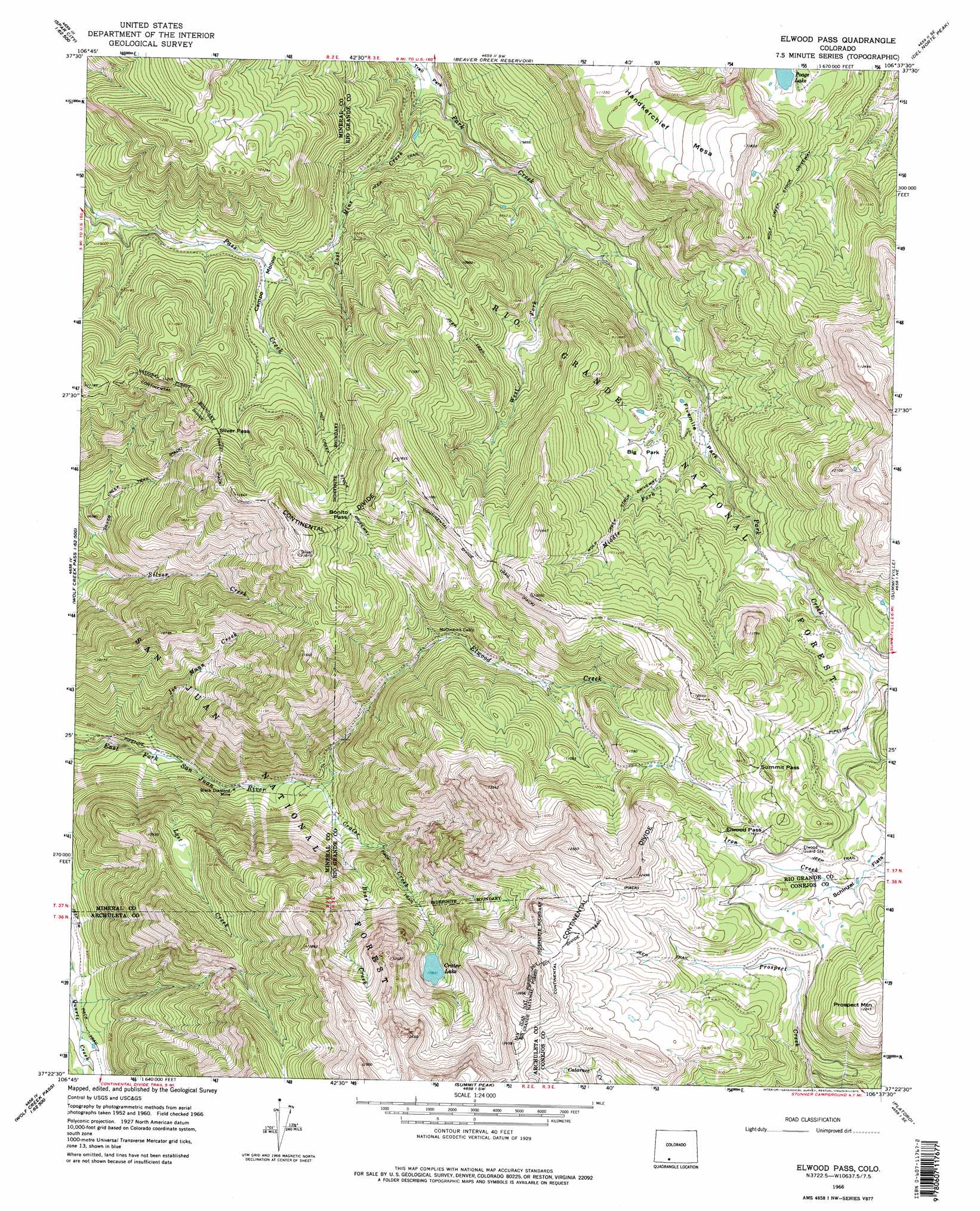
USGS Topo Quad 37106d6 - 1:24,000 scale
| Topo Map Name: | Elwood Pass |
| USGS Topo Quad ID: | 37106d6 |
| Print Size: | ca. 21 1/4" wide x 27" high |
| Southeast Coordinates: | 37.375° N latitude / 106.625° W longitude |
| Map Center Coordinates: | 37.4375° N latitude / 106.6875° W longitude |
| U.S. State: | CO |
| Filename: | o37106d6.jpg |
| Download Map JPG Image: | Elwood Pass topo map 1:24,000 scale |
| Map Type: | Topographic |
| Topo Series: | 7.5´ |
| Map Scale: | 1:24,000 |
| Source of Map Images: | United States Geological Survey (USGS) |
| Alternate Map Versions: |
Elwood Pass CO 1966, updated 1968 Download PDF Buy paper map Elwood Pass CO 1966, updated 1968 Download PDF Buy paper map Elwood Pass CO 1966, updated 1975 Download PDF Buy paper map Elwood Pass CO 2001, updated 2005 Download PDF Buy paper map Elwood Pass CO 2001, updated 2005 Download PDF Buy paper map Elwood Pass CO 2011 Download PDF Buy paper map Elwood Pass CO 2013 Download PDF Buy paper map Elwood Pass CO 2016 Download PDF Buy paper map |
| FStopo: | US Forest Service topo Elwood Pass is available: Download FStopo PDF Download FStopo TIF |
1:24,000 Topo Quads surrounding Elwood Pass
Spar City |
Lake Humphreys |
South Fork West |
South Fork East |
Indian Head |
South River Creek |
Mount Hope |
Beaver Creek Reservoir |
Del Norte Peak |
Horseshoe Mountain |
Saddle Mountain |
Wolf Creek Pass |
Elwood Pass |
Summitville |
Jasper |
Jackson Mountain |
Blackhead Peak |
Summit Peak |
Platoro |
Red Mountain |
Serviceberry Mountain |
Harris Lake |
Elephant Head Rock |
Victoria Lake |
Spectacle Lake |
> Back to 37106a1 at 1:100,000 scale
> Back to 37106a1 at 1:250,000 scale
> Back to U.S. Topo Maps home
Elwood Pass topo map: Gazetteer
Elwood Pass: Flats
Big Park elevation 3233m 10606′Campo Molino elevation 3094m 10150′
Fivemile Park elevation 3151m 10337′
Schinzel Flats elevation 3463m 11361′
Elwood Pass: Gaps
Bonito Pass elevation 3431m 11256′Elwood Pass elevation 3551m 11650′
Railroad Pass elevation 3354m 11003′
Summit Pass elevation 3592m 11784′
Elwood Pass: Lakes
Crater Lake elevation 3324m 10905′Poage Lake elevation 3372m 11062′
Swale Lake elevation 3019m 9904′
Elwood Pass: Mines
Black Diamond Mine elevation 2749m 9019′Lady Bug Mine elevation 2929m 9609′
Robert Burns Claim elevation 2927m 9603′
Elwood Pass: Streams
Bear Creek elevation 2870m 9416′Crater Creek elevation 2817m 9242′
Elwood Creek elevation 2817m 9242′
Lost Creek elevation 2674m 8772′
Middle Fork Park Creek elevation 3157m 10357′
West Fork Park Creek elevation 2962m 9717′
Elwood Pass: Summits
Handkerchief Mesa elevation 3604m 11824′Long Trek Mountain elevation 3911m 12831′
Prospect Mountain elevation 3733m 12247′
Elwood Pass: Trails
Hot Creek Stock Driveway elevation 3269m 10725′Silver Creek Trail elevation 2967m 9734′
Elwood Pass digital topo map on disk
Buy this Elwood Pass topo map showing relief, roads, GPS coordinates and other geographical features, as a high-resolution digital map file on DVD: