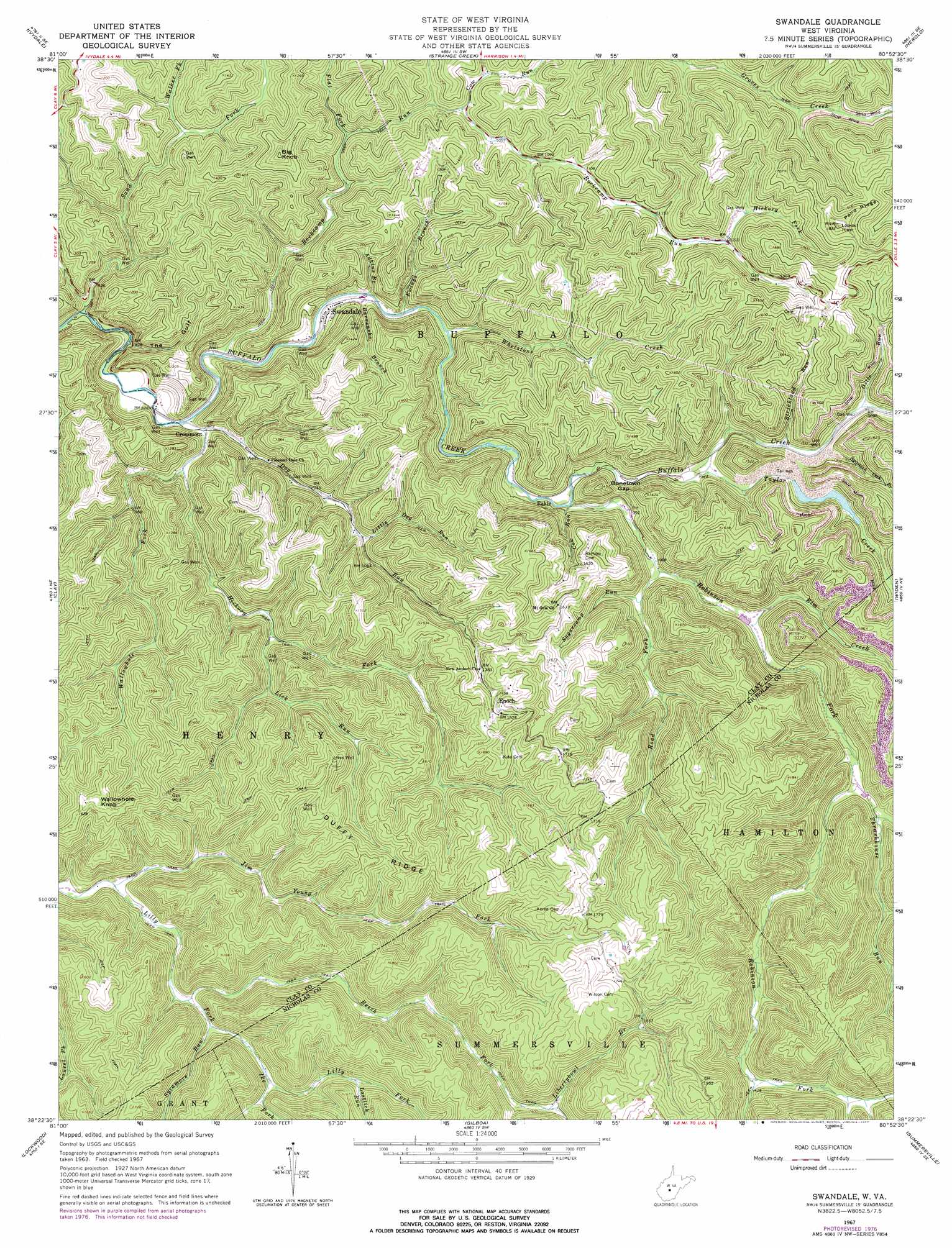
Swandale Topo Map West Virginia
To zoom in, hover over the map of Swandale
USGS Topo Quad 38080d8 - 1:24,000 scale
| Topo Map Name: | Swandale |
| USGS Topo Quad ID: | 38080d8 |
| Print Size: | ca. 21 1/4" wide x 27" high |
| Southeast Coordinates: | 38.375° N latitude / 80.875° W longitude |
| Map Center Coordinates: | 38.4375° N latitude / 80.9375° W longitude |
| U.S. State: | WV |
| Filename: | o38080d8.jpg |
| Download Map JPG Image: | Swandale topo map 1:24,000 scale |
| Map Type: | Topographic |
| Topo Series: | 7.5´ |
| Map Scale: | 1:24,000 |
| Source of Map Images: | United States Geological Survey (USGS) |
| Alternate Map Versions: |
Swandale WV 1967, updated 1968 Download PDF Buy paper map Swandale WV 1967, updated 1977 Download PDF Buy paper map Swandale WV 2011 Download PDF Buy paper map Swandale WV 2014 Download PDF Buy paper map Swandale WV 2016 Download PDF Buy paper map |
1:24,000 Topo Quads surrounding Swandale
Tariff |
Chloe |
Rosedale |
Gassaway |
Sutton |
Newton |
Ivydale |
Strange Creek |
Herold |
Little Birch |
Elkhurst |
Clay |
Swandale |
Widen |
Tioga |
Bentree |
Lockwood |
Gilboa |
Summersville |
Craigsville |
Gauley Bridge |
Ansted |
Summersville Dam |
Mount Nebo |
Nettie |
> Back to 38080a1 at 1:100,000 scale
> Back to 38080a1 at 1:250,000 scale
> Back to U.S. Topo Maps home
Swandale topo map: Gazetteer
Swandale: Dams
Widen-Taylor Fork Dam elevation 362m 1187′Swandale: Gaps
Bonetown Gap elevation 346m 1135′Swandale: Populated Places
Cressmont elevation 256m 839′Eakle elevation 334m 1095′
Enoch elevation 451m 1479′
Swandale elevation 268m 879′
Swandale: Reservoirs
Taylor Fork Refuse Disposal Lake elevation 362m 1187′Swandale: Ridges
Duffy Ridge elevation 499m 1637′Pond Ridge elevation 515m 1689′
Swandale: Streams
Adkins Branch elevation 264m 866′Barrenshe Branch elevation 266m 872′
Beech Fork elevation 320m 1049′
Cow Run elevation 293m 961′
Cow Run elevation 313m 1026′
Dille Run elevation 333m 1092′
Dog Run elevation 255m 836′
Elm Creek elevation 325m 1066′
Ewings Branch elevation 269m 882′
Flat Fork elevation 298m 977′
Hickory Fork elevation 262m 859′
Hickory Fork elevation 367m 1204′
Hogpen Run elevation 368m 1207′
Ike Fork elevation 346m 1135′
Jim Young Fork elevation 301m 987′
Libertybowl Branch elevation 422m 1384′
Lick Run elevation 301m 987′
Little Dog Run elevation 308m 1010′
Lostlick Run elevation 390m 1279′
Road Fork elevation 308m 1010′
Robinson Fork elevation 292m 958′
Rockcamp Run elevation 257m 843′
Sand Fork elevation 244m 800′
Spanish Oak Branch elevation 370m 1213′
Strickland Run elevation 321m 1053′
Sugarcamp Run elevation 319m 1046′
Sycamore Run elevation 328m 1076′
Taylor Creek elevation 318m 1043′
Thrashhouse Run elevation 365m 1197′
Walker Fork elevation 290m 951′
Wallowhole Fork elevation 250m 820′
Whetstone Creek elevation 274m 898′
Swandale: Summits
Big Knob elevation 487m 1597′Wallowhole Knob elevation 513m 1683′
Swandale: Valleys
The Gulf elevation 256m 839′Swandale digital topo map on disk
Buy this Swandale topo map showing relief, roads, GPS coordinates and other geographical features, as a high-resolution digital map file on DVD:
Western Virginia & Southern West Virginia
Buy digital topo maps: Western Virginia & Southern West Virginia