Clay Topo Map West Virginia
To zoom in, hover over the map of Clay
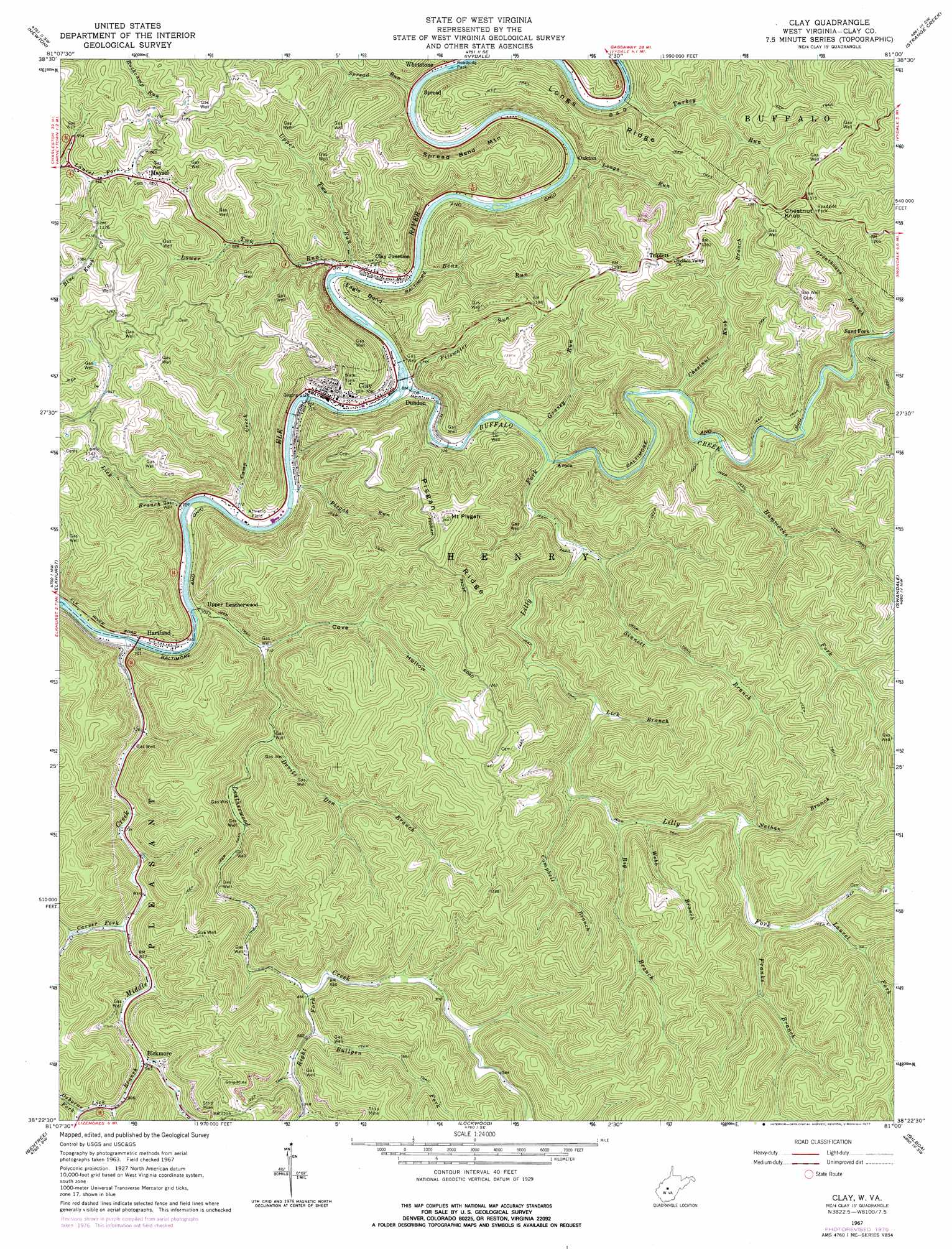
USGS Topo Quad 38081d1 - 1:24,000 scale
| Topo Map Name: | Clay |
| USGS Topo Quad ID: | 38081d1 |
| Print Size: | ca. 21 1/4" wide x 27" high |
| Southeast Coordinates: | 38.375° N latitude / 81° W longitude |
| Map Center Coordinates: | 38.4375° N latitude / 81.0625° W longitude |
| U.S. State: | WV |
| Filename: | o38081d1.jpg |
| Download Map JPG Image: | Clay topo map 1:24,000 scale |
| Map Type: | Topographic |
| Topo Series: | 7.5´ |
| Map Scale: | 1:24,000 |
| Source of Map Images: | United States Geological Survey (USGS) |
| Alternate Map Versions: |
Clay WV 1967, updated 1968 Download PDF Buy paper map Clay WV 1967, updated 1977 Download PDF Buy paper map Clay WV 2011 Download PDF Buy paper map Clay WV 2014 Download PDF Buy paper map Clay WV 2016 Download PDF Buy paper map |
1:24,000 Topo Quads surrounding Clay
Looneyville |
Tariff |
Chloe |
Rosedale |
Gassaway |
Clio |
Newton |
Ivydale |
Strange Creek |
Herold |
Clendenin |
Elkhurst |
Clay |
Swandale |
Widen |
Mammoth |
Bentree |
Lockwood |
Gilboa |
Summersville |
Montgomery |
Gauley Bridge |
Ansted |
Summersville Dam |
Mount Nebo |
> Back to 38081a1 at 1:100,000 scale
> Back to 38080a1 at 1:250,000 scale
> Back to U.S. Topo Maps home
Clay topo map: Gazetteer
Clay: Bends
Eagle Bend elevation 281m 921′Clay: Bridges
Dundon Bridge elevation 210m 688′Clay: Populated Places
Avoca elevation 220m 721′Bickmore elevation 289m 948′
Clay elevation 216m 708′
Clay Junction elevation 221m 725′
Dundon elevation 216m 708′
Hartland elevation 222m 728′
Jamestown (historical) elevation 238m 780′
Maysel elevation 314m 1030′
Morocco (historical) elevation 222m 728′
Oakton elevation 215m 705′
Sand Fork elevation 248m 813′
Spread elevation 227m 744′
Triplett elevation 402m 1318′
Two Run elevation 214m 702′
Upper Leatherwood elevation 207m 679′
Clay: Post Offices
Bickmore Post Office elevation 288m 944′Maysel Post Office elevation 318m 1043′
Clay: Ridges
Longs Ridge elevation 389m 1276′Pisgah Ridge elevation 480m 1574′
Clay: Springs
Herman Nelson Spring elevation 396m 1299′Clay: Streams
Bens Run elevation 211m 692′Big Branch elevation 261m 856′
Buffalo Creek elevation 207m 679′
Bullpen Fork elevation 265m 869′
Camp Creek elevation 207m 679′
Campbell Branch elevation 255m 836′
Carver Fork elevation 259m 849′
Chestnut Knob Branch elevation 223m 731′
Devils Den Branch elevation 226m 741′
Fitzwater Run elevation 207m 679′
Franks Branch elevation 426m 1397′
Grassy Run elevation 216m 708′
Greathouse Branch elevation 240m 787′
Hammocks Fork elevation 227m 744′
Laurel Fork elevation 287m 941′
Leatherwood Creek elevation 207m 679′
Lick Branch elevation 286m 938′
Lick Branch elevation 207m 679′
Lick Branch elevation 245m 803′
Lilly Fork elevation 215m 705′
Longs Run elevation 214m 702′
Lower Two Run elevation 212m 695′
Middle Creek elevation 207m 679′
Nathan Branch elevation 275m 902′
Osborne Fork elevation 316m 1036′
Pisgah Run elevation 207m 679′
Right Fork Leatherwood Creek elevation 259m 849′
Sinnett Branch elevation 225m 738′
Turkey Run elevation 219m 718′
Upper Two Run elevation 211m 692′
Webb Branch elevation 262m 859′
Clay: Summits
Chestnut Knob elevation 447m 1466′Mount Pisgah elevation 499m 1637′
Spread Bend Mountain elevation 395m 1295′
Clay: Valleys
Cannel Coal Hollow elevation 287m 941′Cove Hollow elevation 217m 711′
Clay digital topo map on disk
Buy this Clay topo map showing relief, roads, GPS coordinates and other geographical features, as a high-resolution digital map file on DVD:
Western Virginia & Southern West Virginia
Buy digital topo maps: Western Virginia & Southern West Virginia