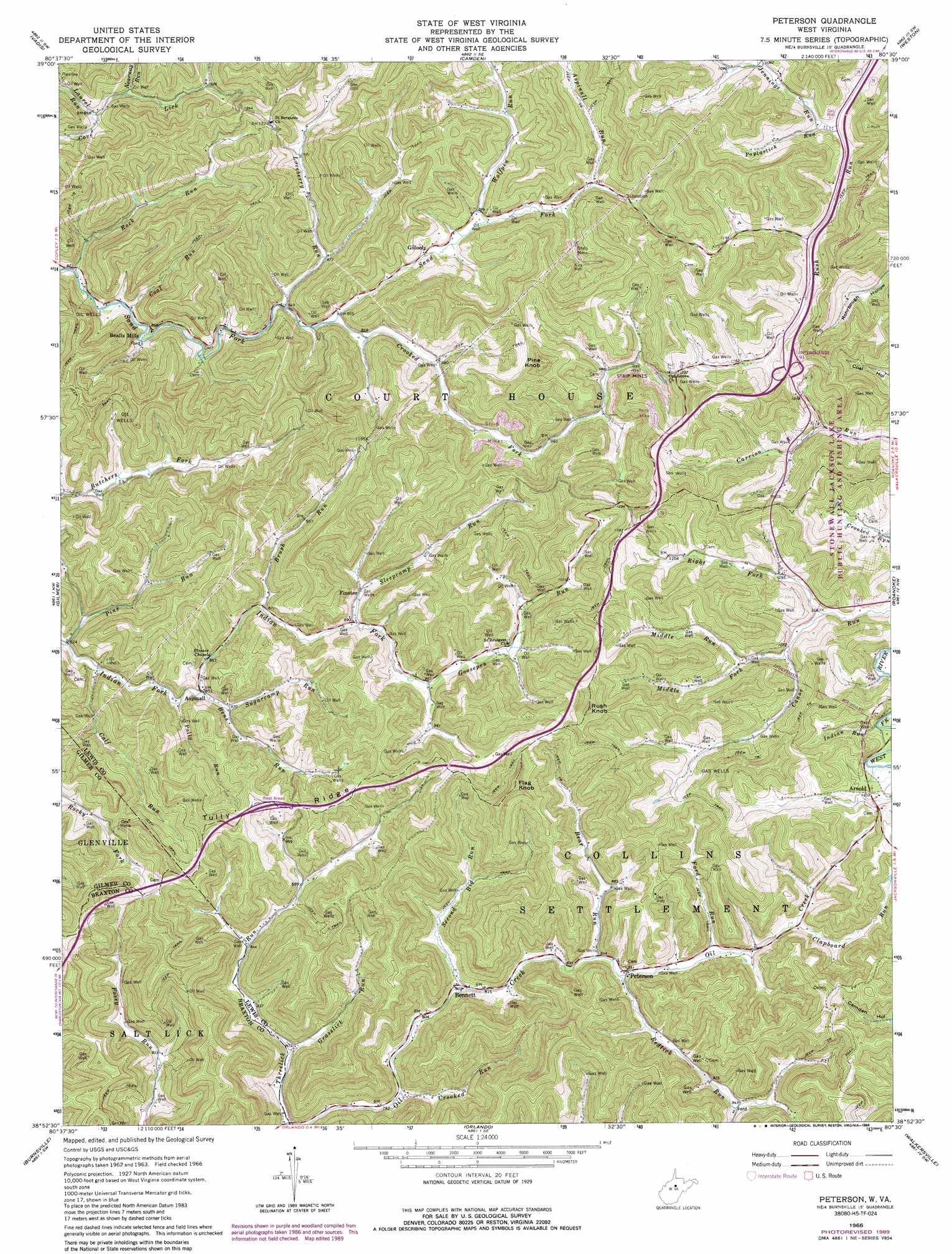
Peterson Topo Map West Virginia
To zoom in, hover over the map of Peterson
USGS Topo Quad 38080h5 - 1:24,000 scale
| Topo Map Name: | Peterson |
| USGS Topo Quad ID: | 38080h5 |
| Print Size: | ca. 21 1/4" wide x 27" high |
| Southeast Coordinates: | 38.875° N latitude / 80.5° W longitude |
| Map Center Coordinates: | 38.9375° N latitude / 80.5625° W longitude |
| U.S. State: | WV |
| Filename: | o38080h5.jpg |
| Download Map JPG Image: | Peterson topo map 1:24,000 scale |
| Map Type: | Topographic |
| Topo Series: | 7.5´ |
| Map Scale: | 1:24,000 |
| Source of Map Images: | United States Geological Survey (USGS) |
| Alternate Map Versions: |
Peterson WV 1966, updated 1968 Download PDF Buy paper map Peterson WV 1966, updated 1977 Download PDF Buy paper map Peterson WV 1966, updated 1989 Download PDF Buy paper map Peterson WV 2010 Download PDF Buy paper map Peterson WV 2014 Download PDF Buy paper map Peterson WV 2016 Download PDF Buy paper map |
1:24,000 Topo Quads surrounding Peterson
Oxford |
New Milton |
Big Isaac |
West Milford |
Mount Clare |
Auburn |
Vadis |
Camden |
Weston |
Berlin |
Glenville |
Gilmer |
Peterson |
Roanoke |
Adrian |
Cedarville |
Burnsville |
Orlando |
Walkersville |
Rock Cave |
Gassaway |
Sutton |
Newville |
Hacker Valley |
Goshen |
> Back to 38080e1 at 1:100,000 scale
> Back to 38080a1 at 1:250,000 scale
> Back to U.S. Topo Maps home
Peterson topo map: Gazetteer
Peterson: Crossings
Interchange 91 elevation 392m 1286′Peterson: Populated Places
Arnold elevation 336m 1102′Aspinall elevation 263m 862′
Bealls Mills elevation 263m 862′
Bennett elevation 246m 807′
Finster elevation 275m 902′
Gillooly elevation 265m 869′
Peterson elevation 258m 846′
Peterson: Ridges
Tully Ridge elevation 369m 1210′Peterson: Springs
Heavner Spring elevation 307m 1007′Peterson: Streams
Aspinall Run elevation 281m 921′Bear Run elevation 253m 830′
Bens Run elevation 258m 846′
Brush Run elevation 273m 895′
Calf Run elevation 258m 846′
Clapboard Run elevation 277m 908′
Coal Run elevation 251m 823′
Crooked Fork elevation 259m 849′
Crooked Run elevation 240m 787′
Ford Run elevation 266m 872′
Goosepen Run elevation 277m 908′
Grasslick Run elevation 242m 793′
Indian Run elevation 327m 1072′
Jennings Run elevation 322m 1056′
Laurel Run elevation 259m 849′
Loveberry Run elevation 259m 849′
Middle Fork Canoe Run elevation 331m 1085′
Middle Run elevation 332m 1089′
Nearway Run elevation 265m 869′
Pine Run elevation 249m 816′
Polly Run elevation 256m 839′
Poplarlick Run elevation 322m 1056′
Raccoon Run elevation 328m 1076′
Redlick Run elevation 256m 839′
Right Fork Canoe Run elevation 327m 1072′
Rock Run elevation 247m 810′
Second Big Run elevation 244m 800′
Sleepcamp Run elevation 268m 879′
Sugarcamp Run elevation 262m 859′
Wolfpen Run elevation 265m 869′
Peterson: Summits
Flag Knob elevation 474m 1555′Pine Knob elevation 448m 1469′
Rush Knob elevation 505m 1656′
Peterson digital topo map on disk
Buy this Peterson topo map showing relief, roads, GPS coordinates and other geographical features, as a high-resolution digital map file on DVD:
Western Virginia & Southern West Virginia
Buy digital topo maps: Western Virginia & Southern West Virginia