Scott Depot Topo Map West Virginia
To zoom in, hover over the map of Scott Depot
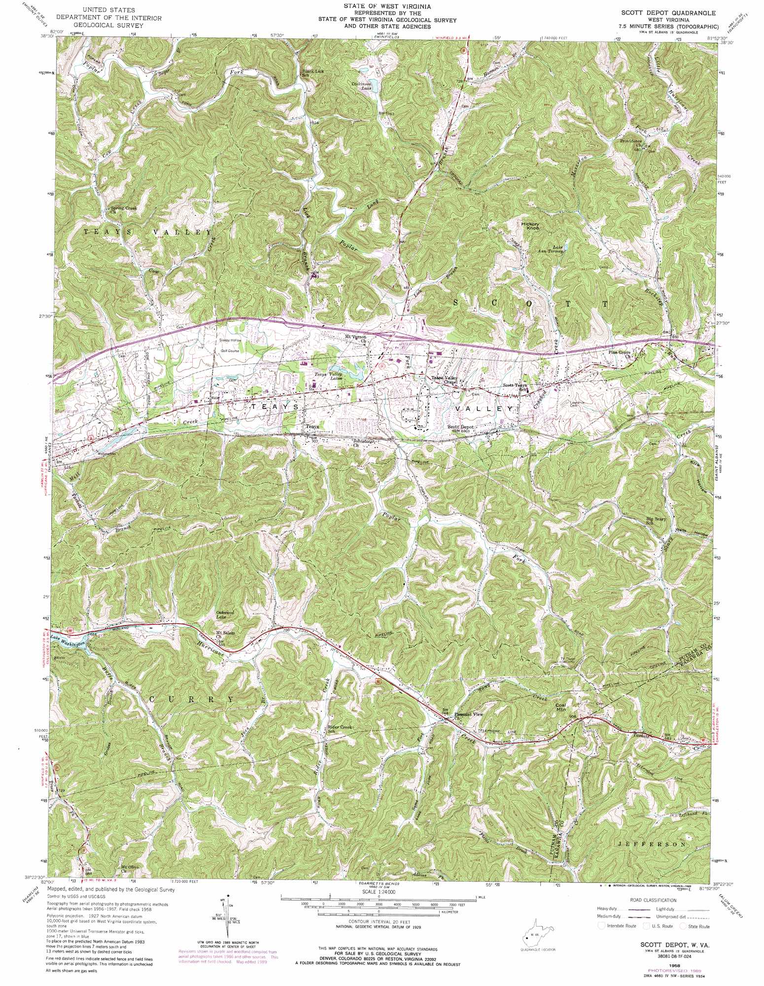
USGS Topo Quad 38081d8 - 1:24,000 scale
| Topo Map Name: | Scott Depot |
| USGS Topo Quad ID: | 38081d8 |
| Print Size: | ca. 21 1/4" wide x 27" high |
| Southeast Coordinates: | 38.375° N latitude / 81.875° W longitude |
| Map Center Coordinates: | 38.4375° N latitude / 81.9375° W longitude |
| U.S. State: | WV |
| Filename: | o38081d8.jpg |
| Download Map JPG Image: | Scott Depot topo map 1:24,000 scale |
| Map Type: | Topographic |
| Topo Series: | 7.5´ |
| Map Scale: | 1:24,000 |
| Source of Map Images: | United States Geological Survey (USGS) |
| Alternate Map Versions: |
Scott Depot WV 1958, updated 1960 Download PDF Buy paper map Scott Depot WV 1958, updated 1968 Download PDF Buy paper map Scott Depot WV 1958, updated 1973 Download PDF Buy paper map Scott Depot WV 1958, updated 1989 Download PDF Buy paper map Scott Depot WV 1977, updated 1980 Download PDF Buy paper map Scott Depot WV 2011 Download PDF Buy paper map Scott Depot WV 2014 Download PDF Buy paper map Scott Depot WV 2016 Download PDF Buy paper map |
1:24,000 Topo Quads surrounding Scott Depot
Apple Grove |
Arlee |
Robertsburg |
Elmwood |
Kenna |
Glenwood |
Mount Olive |
Winfield |
Bancroft |
Sissonville |
Milton |
Hurricane |
Scott Depot |
Saint Albans |
Pocatalico |
West Hamlin |
Hamlin |
Garretts Bend |
Alum Creek |
Charleston West |
Branchland |
Hager |
Griffithsville |
Julian |
Racine |
> Back to 38081a1 at 1:100,000 scale
> Back to 38080a1 at 1:250,000 scale
> Back to U.S. Topo Maps home
Scott Depot topo map: Gazetteer
Scott Depot: Crossings
Interchange 39 elevation 206m 675′Scott Depot: Dams
Hurricane Water Supply Reservoir Dam elevation 198m 649′Lake Oakwood Dam elevation 215m 705′
Sleepy Hollow Golf Club Reservoir Dam elevation 238m 780′
Scott Depot: Parks
Hurricane City Park elevation 197m 646′Scott Depot: Populated Places
Autumn Wynds elevation 219m 718′Belle Acres elevation 210m 688′
Black Lick Estates elevation 226m 741′
Candlewyck Place elevation 225m 738′
Cherry Grove elevation 225m 738′
Cheyenne Valley elevation 210m 688′
Colonial Gardens elevation 212m 695′
Country Villas elevation 215m 705′
Dogwood Estates elevation 203m 666′
Englewood Estates elevation 213m 698′
Fairview elevation 211m 692′
Fairway Gardens elevation 216m 708′
Hickory Hill elevation 217m 711′
Hidden Valley Estates elevation 224m 734′
Kenmar Trailer Park elevation 230m 754′
Lexington Estates elevation 212m 695′
Mount Vernon Meadows elevation 222m 728′
Oakwood Estates elevation 219m 718′
Ranch Lake Estates elevation 235m 770′
Rolling Meadows elevation 215m 705′
Saunders Addition elevation 205m 672′
Scott Depot elevation 209m 685′
Scott Village elevation 212m 695′
Sleepy Hollow Township elevation 212m 695′
Springdale Estates elevation 214m 702′
Sun Valley Estates elevation 206m 675′
Teays elevation 212m 695′
Teays Farm elevation 273m 895′
Teays Meadow elevation 222m 728′
Teays Valley elevation 203m 666′
Teays Valley Estates elevation 236m 774′
Teays Valley Meadows elevation 208m 682′
Teays Villa elevation 208m 682′
Teays Village elevation 228m 748′
The Ridge Estates elevation 231m 757′
Valley View Estates elevation 218m 715′
Winsor Court elevation 213m 698′
Woodcliffe Chase elevation 214m 702′
Woods and Irons elevation 220m 721′
Woods and Irons East elevation 215m 705′
Woods and Irons South elevation 211m 692′
Scott Depot: Post Offices
Scott Depot Post Office elevation 216m 708′Teays Post Office elevation 211m 692′
Scott Depot: Reservoirs
Dickinson Lake elevation 234m 767′Hurricane Lake elevation 198m 649′
I-64 Lake elevation 238m 780′
Lake Ann Tormey elevation 243m 797′
Oakwood Lake elevation 216m 708′
Teays Valley Lakes elevation 215m 705′
Scott Depot: Springs
Bruce Hunt Spring elevation 283m 928′Cottle Spring elevation 223m 731′
Cottle Spring elevation 284m 931′
Ensell Mercer Spring elevation 249m 816′
Ensell Mercer Spring elevation 271m 889′
Ervan Coiner Junior Spring elevation 212m 695′
Farley Spring elevation 245m 803′
Henson Spring elevation 232m 761′
Hubert Beaver Spring elevation 234m 767′
Leyton Fisher Spring elevation 204m 669′
Lois Umberger Spring elevation 209m 685′
Mercer Spring elevation 296m 971′
Mercer Spring elevation 272m 892′
Mynes Spring elevation 258m 846′
Russell Mercer Spring elevation 281m 921′
Shermans Place Spring elevation 208m 682′
Wyant Spring elevation 227m 744′
Scott Depot: Streams
Buffs Branch elevation 199m 652′Cow Creek elevation 179m 587′
Crooked Creek elevation 204m 669′
Fields Brook elevation 200m 656′
Grobes Branch elevation 201m 659′
Joes Branch elevation 209m 685′
Lick Branch elevation 187m 613′
Lick Branch elevation 192m 629′
Long Branch elevation 202m 662′
Mill Creek elevation 186m 610′
Morrison Fork elevation 185m 606′
Rider Creek elevation 216m 708′
Sams Fork elevation 222m 728′
Snag Creek elevation 228m 748′
Sugar Branch elevation 182m 597′
Tackett Branch elevation 188m 616′
Scott Depot: Summits
Coal Mountain elevation 325m 1066′Hickory Knob elevation 310m 1017′
Scott Depot: Valleys
Kirk Hollow elevation 184m 603′Wells Hollow elevation 191m 626′
Scott Depot digital topo map on disk
Buy this Scott Depot topo map showing relief, roads, GPS coordinates and other geographical features, as a high-resolution digital map file on DVD:
Western Virginia & Southern West Virginia
Buy digital topo maps: Western Virginia & Southern West Virginia