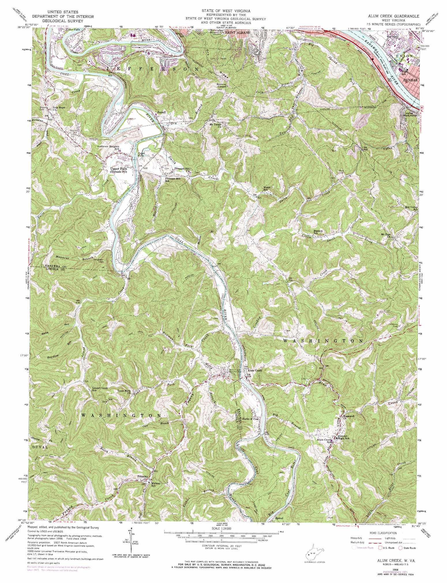
Alum Creek Topo Map West Virginia
To zoom in, hover over the map of Alum Creek
USGS Topo Quad 38081c7 - 1:24,000 scale
| Topo Map Name: | Alum Creek |
| USGS Topo Quad ID: | 38081c7 |
| Print Size: | ca. 21 1/4" wide x 27" high |
| Southeast Coordinates: | 38.25° N latitude / 81.75° W longitude |
| Map Center Coordinates: | 38.3125° N latitude / 81.8125° W longitude |
| U.S. State: | WV |
| Filename: | o38081c7.jpg |
| Download Map JPG Image: | Alum Creek topo map 1:24,000 scale |
| Map Type: | Topographic |
| Topo Series: | 7.5´ |
| Map Scale: | 1:24,000 |
| Source of Map Images: | United States Geological Survey (USGS) |
| Alternate Map Versions: |
Alum Creek WV 1958, updated 1960 Download PDF Buy paper map Alum Creek WV 1958, updated 1967 Download PDF Buy paper map Alum Creek WV 1958, updated 1973 Download PDF Buy paper map Alum Creek WV 1976, updated 1980 Download PDF Buy paper map Alum Creek WV 2011 Download PDF Buy paper map Alum Creek WV 2014 Download PDF Buy paper map Alum Creek WV 2016 Download PDF Buy paper map |
1:24,000 Topo Quads surrounding Alum Creek
Mount Olive |
Winfield |
Bancroft |
Sissonville |
Romance |
Hurricane |
Scott Depot |
Saint Albans |
Pocatalico |
Big Chimney |
Hamlin |
Garretts Bend |
Alum Creek |
Charleston West |
Charleston East |
Hager |
Griffithsville |
Julian |
Racine |
Belle |
Big Creek |
Mud |
Madison |
Williams Mountain |
Sylvester |
> Back to 38081a1 at 1:100,000 scale
> Back to 38080a1 at 1:250,000 scale
> Back to U.S. Topo Maps home
Alum Creek topo map: Gazetteer
Alum Creek: Falls
Lower Falls elevation 173m 567′Upper Falls elevation 174m 570′
Alum Creek: Parks
Saint Albans City Park elevation 268m 879′Alum Creek: Populated Places
Alum Creek elevation 189m 620′Beech Park Acres elevation 213m 698′
Ferrell elevation 184m 603′
Forks of Coal elevation 189m 620′
Green Valley elevation 183m 600′
Lincoln Park elevation 179m 587′
Lone Oak Park elevation 184m 603′
Priestley elevation 205m 672′
River Bend elevation 184m 603′
Riverlake elevation 184m 603′
Sproul elevation 191m 626′
Sun Valley elevation 184m 603′
Sweet Acres elevation 199m 652′
Tornado elevation 186m 610′
Upper Falls elevation 187m 613′
Alum Creek: Post Offices
Tornado Post Office elevation 186m 610′Alum Creek: Ridges
Dry Ridge elevation 316m 1036′Alum Creek: Streams
Alum Creek elevation 178m 583′Angel Fork elevation 179m 587′
Beech Branch elevation 202m 662′
Big Branch elevation 178m 583′
Big Coal River elevation 182m 597′
Big Spring Fork elevation 176m 577′
Boardtree Run elevation 202m 662′
Bowman Fork elevation 181m 593′
Browns Creek elevation 174m 570′
Cain Branch elevation 182m 597′
Coon Branch elevation 191m 626′
Crooked Creek elevation 182m 597′
Dry Branch elevation 186m 610′
Ezekiel Branch elevation 181m 593′
Falls Creek elevation 181m 593′
Finney Branch elevation 174m 570′
Fuquay Creek elevation 179m 587′
Indian Creek elevation 172m 564′
Island Creek elevation 177m 580′
Little Alum Creek elevation 216m 708′
Little Coal River elevation 182m 597′
Little Smith Creek elevation 204m 669′
Mahone Branch elevation 182m 597′
Mannens Branch elevation 177m 580′
Martin Creek elevation 179m 587′
Molly Branch elevation 182m 597′
Road Fork elevation 206m 675′
Rocky Run elevation 198m 649′
Smith Creek elevation 174m 570′
Toms Fork elevation 186m 610′
Upton Creek elevation 179m 587′
Alum Creek digital topo map on disk
Buy this Alum Creek topo map showing relief, roads, GPS coordinates and other geographical features, as a high-resolution digital map file on DVD:
Western Virginia & Southern West Virginia
Buy digital topo maps: Western Virginia & Southern West Virginia